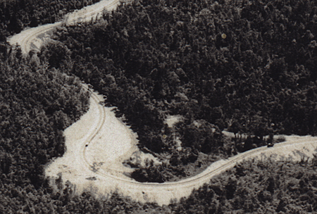
On December 19, I wrote about the Lincoln Highway’s original course on Tuscarora Mountain east of McConnellsburg, Pennsylvania. Of particular concern to explorers and researchers is the course of the “Horseshoe Curve” halfway up — two turnoffs leave us wondering about the original route. While researching my Ship Hotel book, I came across this 1930s aerial postcard showing the old and new curves — answering the question and now giving purpose to those who go exploring.

The red circle marks Doc Seylar’s, famed mountaintop stop on Tuscarora Summit; McConnellsburg is off to the right. Below is a close-up of the Horseshoe Curves, both old and new. Of course, both were obliterated about 1970 when a third Horseshoe Curve was built to serve the US 30 bypass around town, leaving only remnants of these two.

A postcard folder that I found also has two photos of the new curve. The first view calls it the Beauty Curve; the other, just a few feet west, notes it as the Horseshoe Curve. It must have been quite an engineering feat in the early ’30s.
Tags: historic highway, Lincoln Highway, McConnelsburg PA, old highway detective work, road realignment
February 4, 2009 at 3:55 pm |
That’s a really exciting find! That would have been a fun road to drive.