Waymarking is like a scavenger hunt for interesting places. Using a GPS locator, waymarking not only means marking a location using latitude and longitude coordinates, but categorizing it and adding unique information for others to learn about it. That’s why those of us who only see the results online can still follow along in the fun. There are more than 70 Lincoln Highway markers of all sorts on Waymarking.com, from murals to brick monuments in Ohio, and especially the 1928 concrete posts (originals and reproductions). Waymarkers post an image or two at each location and supply a description. Here are some nice examples, all used with permission.
This marker painted on a pole just east of Central City, Nebraska. was located by plainsdrifter358, aka Barbara and Bill.

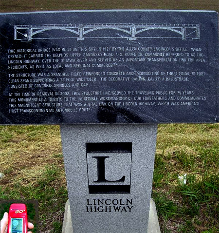
The marker below comemmorates the 1927 concrete bridge that carried the LH/Delphos-Upper Sandusky Road over the Ottawa River near Gomer, Ohio, taken by Stephen Shepherd.
The interesting monument below, probably overlooked by LH fans, was found at 1600 Plainfield Road in Joliet by a member cldisme.

According to the plaque at its base, this
life-size cold cast bronze sculpture of a 1915 Joliet road worker, seated on a hand-cut ceramic mosaic column, represents the historic Lincoln Highway and the birth of our modern day highway system. Also, included in the mosaic is an image of Abraham Lincoln medallion. The sculpture is dedicated to the men and women of the Will-Grundy Counties Building Trades Council and the construction companies of the Contractors Association of Will & Grundy Counties who make our roads possible.
On July 1, 1913, a group of automobile enthusiasts and industry officials led by Carl Fisher, created the Lincoln Highway Association (LHA), “to procure the establishment of a continuous improved highway from the Atlantic to the Pacific, open to the lawful traffic of all description without toll charges” and to be a lasting memorial to our 16 th president, Abraham Lincoln. Prior to the Lincoln Highway, the existing roads were nothing more than dirt paths, which became impossible to traverse even after the lightest rain. There were very few filling stations along the proposed route, few places to eat, and even fewer places to find lodging.
Since highway maps and signage did not exist, a uniform way of marking the highway became a necessity. A design was created that consisted of a concrete post, a blue arrow, and Lincoln’s image on a medallion. On July 8, 1928, the Boy Scouts of America installed the concrete sign posts next to 3,100 miles of roadway at all important turns and junction points from New York to San Francisco.
Check out the site for dozens more Lincoln Highway markers along (and sometimes far from) the road.
Tags: highway, Los Angeles, markers, signs, waymarking

May 30, 2009 at 7:06 pm |
Does anyone have sections of the Lincoln highway in Mapsource or Google Earth?
I am working on trying to put together state by state gps coordinates to make the trip a bit easier to navigate since I will be on two wheels.
Thanks
Chris H
November 10, 2009 at 6:17 am |
This does seem to be a problem. There are tons of turn-by-turn GPS system maps out there for Route 66, but none for Lincoln Highway.