Archive for the ‘signs’ Category
October 22, 2019
LINCOLN HIGHWAY NEWS IS A BLOG BY BRIAN BUTKO

Effie Gladding had just returned from three years touring the world when she departed from San Francisco on April 21, 1914. She and her husband, Thomas, drove the El Camino Real 600 miles south before turning and meeting the Lincoln Highway at Stockton, California. In a 262-page book titled Across the Continent by the Lincoln Highway, she doesn’t reach the focus of her title until page 108, then detours off it for another 47 pages near the end, skipping most of Ohio and Pennsylvania. Still, hers was the first full-size hardback to discuss transcontinental travel, as well as the first to mention the Lincoln Highway:
“We were now to traverse the Lincoln Highway and were to be guided by the red, white, and blue marks; sometimes painted on telephone poles, sometimes put up by way of advertisement over garage doors or swinging on hotel signboards; sometimes painted on little stakes, like croquet goals, scattered along over the great spaces of the desert. We learned to love the red, white, and blue, and the familiar big L which told us that we were on the right road.”
After her return, Gladding wrote the foreword to the LHA’s first road guide, directing her words to women motorists.
Effie’s story and lots more can be found in Greetings from the Lincoln Highway, my big book of LH history now in its 3rd edition!
Tags:automotive history, books, California, highway history, history, Road trip, San Francisco, travel, women's history
Posted in highways, history, Lincoln Highway, Road trip, roadside, signs, transportation, travel, Uncategorized | Leave a Comment »
August 30, 2018
LINCOLN HIGHWAY NEWS IS A BLOG BY BRIAN BUTKO
This story started simply: I had an old postcard of a restaurant in Aurora, Illinois, in my LH collection. The back lists the location as “US business Route 30” so I wanted to check if it was truly on the Lincoln Highway (which is not always the same as Route 30). As is often the case, there’s not a lot of info out there on a restaurant from long ago, but what remains paints a story of an interesting family business.
Bit of Sweden Smorgasbord opened in 1955 on the east side of Aurora at 110 Hill Ave, on the southeast corner of Benton/Summit. It was across from today’s Hansens Motel, itself a vintage business still operating. Hill and Benton indeed served as the 2nd generation LH and later US 30.


There was already a Bit of Sweden, closer to Chicago on Rush Road, that had opened about 1930. The Aurora restaurant — which would make sense to be related, though I could find no connection — was run by siblings Arvid (b. 1907) and Edith Nelson. For its next 15 or so years, it received a yearly profile in the local newspaper’s dining section.
A 1965 profile said its neon sign showed a dancing Poyk and Flicka (Swedish for little boy and girl), while inside there were more than 50 foods, a stone fireplace, and themed decor: “The smorgasbord tables are set against a background of a pastoral mural and under special Swedish styled modern lighting.” It also included this ad:

The largest profile, in 1960, described some of the food customers got for $2 buffet, including fish, roast spring chicken, Swedish meatballs, scalloped potatoes, baked ham, prime rib, Swiss steak, soup, and pickled herring. Homemade rolls and bread, dessert, and drinks were included, though no alcohol was permitted.

The last profile ran in 1972; by 1975, the equipment was being auctioned … after the place had been converted to BoJangle’s Discoteque. There ends the trail, and story, of Aurora’s Bit of Sweden.
I could find nothing online about Edith, but Arvid (who passed away in 1986) has a fund named in his honor. The Arvid Nelson Memorial Fund was established in 2013 by his son Alan (b. 1937) to support The Community Foundation of the Fox River Valley, a tax-exempt public charity of funds and resources given by local citizens to enhance and support the quality of life in the Fox River Valley. Visit
https://www.communityfoundationfrv.org/profile/nelson-arvid-fund to learn more.
Tags:Aurora IL, history, Illinois, Lincoln Highway, pickled herring, postcards, roadside America, Route 30, Smorgasbord, Swedish, travel
Posted in food, highways, history, Lincoln Highway, Road trip, signs, travel | 1 Comment »
June 5, 2018
LINCOLN HIGHWAY NEWS IS A BLOG BY BRIAN BUTKO

A 1920s postcard of Reel’s Corners, Pa., (now US 30 and PA 160), part of the famed “Seven Mile Stretch” on the Lincoln Highway east of Stoystown.
Onward through Western Pennsylvania with Beatrice Massey in her new Packard:
“It was with regret that we left the next morning for Pittsburgh. The day was clear and cool and the best part of the Lincoln Highway was before us; in fact, the first real thrill so far, and one of the high spots of the trip. This was a stretch of seven and a half miles of tarvia road on the top ridge of the Alleghany Mountains, as smooth as marble, as straight as the bee flies, looking like a strip of satin ribbon as far as the eye could see. On both sides were deep ravines,well wooded,and valleys green with abundant crops, and still higher mountains rising in a haze of blue and purple coloring, making a picture that would never be forgotten. The top was down and we stopped the car again and again, to drink it in, and, as one of us remarked, ‘We may see more grand and rugged scenery later on, but we shall not see anything more beautiful than this’ — and it proved true.”
Tags:1919, Alleghany Mountains, history, Lincoln Highway, PA, postcard, Reel's Corners, travel
Posted in highways, Lincoln Highway, road surface, Road trip, roadside, signs, transportation, travel, Uncategorized | Leave a Comment »
December 2, 2013
LINCOLN HIGHWAY NEWS IS A BLOG BY BRIAN BUTKO
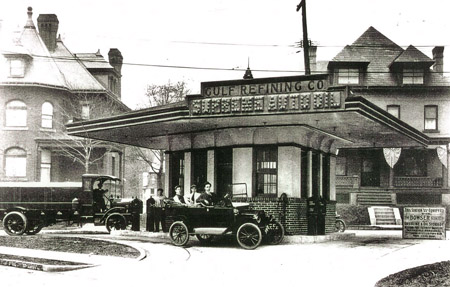
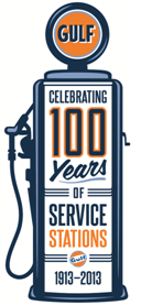
On December 1, 1913, the Lincoln Highway had only celebrated its dedication a month earlier when the world’s first architect-designed drive-in gas station opened along the new coast-to-coast road in Pittsburgh.

Gulf’s pioneering station in Pittsburgh.
Gasoline had been sold for years at hardware stores and other businesses serving the burgeoning auto industry. There were also places selling only gasoline, even drive-in stations.
But the fuel was often kept in barrels and poured from large cans. And unlike those existing buildings or informal shacks, Gulf Oil had an architect design the new building to efficiently and elegantly pump gas and provide other services. In fact, the following year, the station would start giving away the first free oil company road maps.
The station featured a canopy to shield motorists from weather, new Bowser hand-cranked pumps, large incandescent-lit signs, attendants on duty day and night, and the checking of fluids — all new to the industry.
The station was on Baum Boulevard (the Lincoln Highway) at St. Clair Street. Baum was quickly becoming Pitsburgh’s “automobile row” (common in all cities), filling with garages, tire shops, and car dealers — even the local auto club. Baum already served the carriage trade so this was a natural outgrowth. That itself made sense since Baum connected the city to the mansions being built to the east along on Penn Avenue in Point Breeze — also the Lincoln Highway.
An informal station was already operating on the site when landowner James Mellon contracted the new station. The Mellon family was Gulf’s first and foremost investors, intertwining their Mellon Bank and Gulf Oil for decades. Gulf was an early proponent of branding gas, especially with its bright orange circle logo, as opposed to generic gas that was also often of lower quality; a branded station was a natural next step.

The station didn’t last long, perhaps as late as 1950. Since then it’s been a parking lot. In 2000, the Gulfoil Historical Society campaigned for, and helped erect, a state historical marker to the station. I visited the site today, on the station’s 100th birthday, in the Lincoln Highway’s 100th year.
Tags:first architect-designed drive-in gas station, gas station, Gulf, highway history, Lincoln Highway, PA, roadside
Posted in history, Lincoln Highway, roadside, signs, transportation, Uncategorized | 1 Comment »
April 14, 2013
LINCOLN HIGHWAY NEWS IS A BLOG BY BRIAN BUTKO
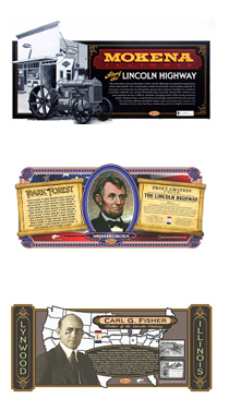
The 33rd roadside mural from the llinois Lincoln Highway Coalition was installed at 137 East 14th Street, Chicago Heights, Illinois. The mural depicts a vintage photo of the McEldowney Bridge that once crossed Thorn Creek in Chicago Heights and Henry C. Ostermann, the Lincoln Highway Association Field Secretary who traveled the Lincoln Highway to inspect it. Chicago Heights is known as the “Crossroads of the Nation” where the Lincoln and Dixie Highways intersect. A special element in this mural is the “L” sign, a three-dimensional piece attached directly to the mural surface.

Another mural was installed the same day in Crest Hill, at 1701 Larkin Avenue in the Hillcrest Shopping Center. The story was also reported at nwitimes.com. For more information or to download an Illinois Lincoln Highway Visitor Guide, visit drivelincolnhighway.com.
Tags:Chicago Heights IL, highway history, historic highway, Illinois, interpretive murals, Lincoln Highway, Road trip
Posted in highways, history, Lincoln Highway, roadside, signs, Uncategorized | Leave a Comment »
March 29, 2013
LINCOLN HIGHWAY NEWS IS A BLOG BY BRIAN BUTKO

Long-time Lincoln Highway advocate Rollin Southwell passed away suddenly on Sunday while in Iowa. Among the many contributions of “The Man from Utah” to Lincoln Highway history, preservation, and promotion was the conception and creation of a monument to Carl Fisher in central Utah.
Rollin’s family has planned a service for Monday, April 1, 2013, 11 am at the Twenty-Seventh East Ward, 185 North P Street (corner of 4th Ave), Salt Lake City. In lieu of flowers, Marie Southwell, Elizabeth Southwell, and Robert Southwell ask that donations be directed to the Utah State Historical Society in honor of Rollin’s love for historical research, particularly the history of the Lincoln Highway.

Tags:highway history, historic highway, Lincoln Highway, Road trip, roadside, Rollin Southwell, travel, Utah
Posted in highways, history, Lincoln Highway, signs, transportation, travel, Uncategorized | 3 Comments »
January 29, 2013
LINCOLN HIGHWAY NEWS IS A BLOG BY BRIAN BUTKO
 The Illinois Lincoln Highway Murals, created by artist Jay Allen for the Illinois Lincoln Highway Coalition, won first place in the Murals/Exhibit Graphics category in an annual sign contest presented by Signs of the Times magazine.
Now the murals are competing in the Signs of the Times 2013 Readers’ Choice Awards. They need YOUR help. It’s EXTREMELY easy and fun to see the competing projects.
Every mural is a hand-painted, unique work of art. So far, 29 have been installed. Upon completion, the series will be one of the largest works of public art in the country.
Visit https://www.surveymonkey.com/s/8DV5THL and vote for your 3 favorite projects, including of course the murals. Voting is limited to once per computer and concludes on February 8.
Tags:highway history, highway mural, Illinois, Lincoln Highway, roadside
Posted in highways, history, Lincoln Highway, roadside, signs, transportation, Uncategorized | Leave a Comment »
January 23, 2013
LINCOLN HIGHWAY NEWS IS A BLOG BY BRIAN BUTKO
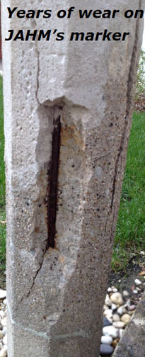
 The Joliet Area Historical Museum, at the crossroads of the Lincoln Highway and Route 66 in Joliet, Illinois, is asking for help in restoring its 1928 Lincoln Highway concrete marker. According to a release, the museum hopes “to raise $5,000 to restore the highway marker which is deteriorating rapidly. Restoration includes: stabilizing the interior rebar, re-adhering the broken segments, removing bronze disease, brightening the paint, and displaying it inside.” Of course, there is no paint — the colors are in the concrete — but the rest sounds like a worthy endeavor.
Read more HERE in the release:
Tags:1928 concrete marker, concrete post, highway history, historic highway, Illinois, Joliet IL, Lincoln Highway, Route 66
Posted in highways, history, Lincoln Highway, museum, signs, transportation, travel, Uncategorized | Leave a Comment »
October 12, 2012
LINCOLN HIGHWAY NEWS IS A BLOG BY BRIAN BUTKO
The Village of Lynwood, Illinois, sports the newest mural in the Illinois Lincoln Highway Heritage Corridor’s series that spans the 179-mile Illinois byway corridor. Lynwood marks the eastern terminus to the Illinois portion of the Lincoln Highway. The mural wasinstalled October 10, 2012, at 21490 East Lincoln Highway, on Lynwood’s Senior/Youth Center building.

ILHC works with artist Jay Allen (above, installing the mural), owner of ShawCraft Sign Company; every mural is a hand painted, unique work of art. Upon completion, the series will be one of the largest works of public art in the country. This mural depicts Carl G. Fisher, the “Father of the Lincoln Highway” and elements of his life that helped turn his dream of the first transcontinental highway into a reality.

For more information on the Illinois Lincoln Highway, places to see and things to do, stories of the highway’s significance and history, or to download an Illinois Lincoln Highway Visitor Guide, visit drivelincolnhighway.com. To see the mural larger, visit my Facebook page at facebook.com/groups/28162312417/.
Tags:Carl Fisher, highway history, historic highway, Illinois, interpretive murals, Lincoln Highway, Road trip
Posted in highways, history, Lincoln Highway, Road trip, roadside, signs, transportation | 3 Comments »
August 8, 2012
LINCOLN HIGHWAY NEWS IS A BLOG BY BRIAN BUTKO
A new mural was placed in Batavia, Illinois, today as part of a series sponsored by the Illinois Lincoln Highway Coalition. The large works of public art stretch along the 179-mile Illinois byway corridor, in over two dozen communities. The latest mural is on the Batavia Floral building at 109 South Batavia Avenue. Artist Jay Allen, owner of ShawCraft Sign Company, created the interpretive mural series.

The Illinois Lincoln Highway Coalition’s multi-site mural project showcases the history of the early highway, bringing the intriguing stories into people’s lives so they can recognize its impact on American travel and the communities. Visit drivelincolnhighway.com for more information on the Illinois Lincoln Highway, places to see and things to do, stories of the highway’s significance and history, or to download an Illinois Lincoln Highway Visitor Guide.

Tags:highway history, historic highway, Illinois, interpretive murals, Lincoln Highway, Road trip, travel
Posted in highways, history, Lincoln Highway, signs, transportation, travel | 1 Comment »