The front of this postcard says it all – Red Top Diner and Shell Station, Highways 24 & 30 East — City Limits, Fort Wayne, Ind.

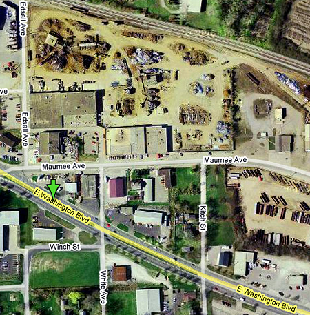
Three train tracks can be seen behind, and the diner looks to be a converted railcar. The automobile is a mid-’30s coupe. Can’t imagine this part of the Lincoln Highway being quite so rural now. Could that be Maumee Avenue right behind the station, and E Washington Blvd in the foreground? The setting looks right and a couple business as seen in this Google aerial view at bottom center and right seem to fit the layout
Anyone know more about Red Top? The picture was taken some 70 years ago, so it’s critical to ask those who might remember before all traces and memories of such places disappear forever.
Tags: Diner, Fort Wayne, gas station, highway, Indiana, postcard, Shell station

January 14, 2008 at 9:17 am |
Could it be an old interurban car? Reminds me of the old Frank’s Diner that use to be in Monroeville, Ohio on U.S. Rte. 20. The length looks right. Frank’s was moved to the Seashore Trolley Museum back in the late 1980’s or early 90’s. John Baeder did a great painting of it.
January 14, 2008 at 12:50 pm |
Yes, it’s likely an old trolley or interurban car. Those were perhaps more adaptable and more widely available, and so used more often as makeshift diners. They tended to wear out faster too, plus the trend was spurred at the turn of the century when horse-drawn cars were retired in favor of electric ones. $20 could get you a nice one from a junkyard – add a stove and some seats and you were in business. Of course, Larry knows all this – click his avatar to read his Diner Hotline blog.
January 14, 2008 at 1:59 pm |
Here is a link to John Baeder’s painting of Frank’s (Interurban) Diner
http://www.johnbaeder.com/Oils/1993-Franks-Interurban-Oil.htm
December 25, 2012 at 8:08 am |
This Photo intrigued me as I am obsessed with finding these locations from the past. I have spent quite a bit of time researching this location tonight and I believe I have found the former location. When It comes to Fort Wayne, you have to find an old map from the period because when this photo was taken Washington Blvd Only went to Glascow to the east and stopped. Route 30 followed new Haven Ave until it went north along Bueter RD. Bueter merged with Maumee (former 24) just west of where the 930 clover leaf exists today. This is the little triangle where the station and cafe sat. You can notice the contours of the tree line, the slight downward hill as it looks north, the alingment of the two roads, and the appropriate proximity of the rail tracks in the background.
Here is a link to the 1935 allen county map:
http://cdm16066.contentdm.oclc.org/cdm/ref/collection/p15078coll8/id/1097
Here is the google map:
https://maps.google.com/maps?q=3772+maumee+ave+fort+wayne&ie=UTF-8&hq=&hnear=0x8815fb38cb777865:0xe788a64274eb258e,3772+Maumee+Ave,+Fort+Wayne,+IN+46803&gl=us&ei=XIjZUN-0Ms2B0QGoz4AI&ved=0CDUQ8gEwAA