Archive for the ‘highways’ Category
July 21, 2008
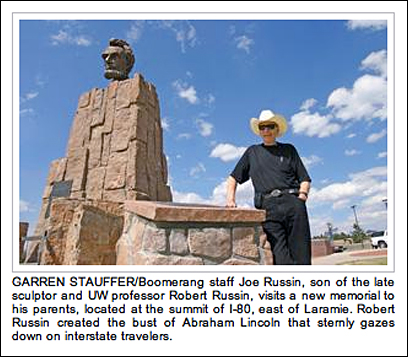
The Laramie Boomerang reports that the ashes of sculptor Robert Russin and his wife Adele have been interred at the monument he created in 1959 to honor Lincoln’s 150th birthday. Its location in eastern Wyoming marked the highest point on the transcontinental Lincoln Highway: 8,835 feet. In 1969, the monument was moved to the nearby Summit Rest Area (exit 323) when I-80 opened between Cheyenne and Laramie, and is now at the highest point along I-80: 8,640 feet.
Above is a screen shot from the article and here’s a bit of the story:
Joe Russin, one of the sculptor’s sons, said his father’s wish was to be laid to rest near the statute [sic].
“The Lincoln statute became his calling card,” Russin said. “It was one of his favorite statutes.”
The mighty statute was actually made in Mexico City and then brought, in pieces, to Wyoming….
“My dad hadn’t thought about how low the wires were over Grand Avenue,” Russin said. “So they had to move it through Laramie really early in the morning and they cut the electric and telephone wires for each block as they went through.”

ABOVE: Sculptor Robert Russin and assistants work on the bust of Abraham Lincoln. Courtesy Jim Kearns, Manager, University of Wyoming Media Relations.
Tags:Abraham Lincoln sculpture, highway monument, Laramie Wyoming, memorial, rest area, sculpture, Wyoming
Posted in highways, history, roadside, transportation, travel | Leave a Comment »
July 18, 2008

We spent last night under a rising full moon at the Twin Hi-Way Drive-In, named for the two roads passing by: the Lincoln Highway and Wm. Penn Highway (later US routes 22 & 30). Opened in 1950 in suburban Pittsburgh, the “drive-in capital,” it had closed in 1996 and sat mostly vacant, hosting volleyball tounaments for the adjacent bar and military-themed haunted attractions at Halloween. Three local partners – Jerry Salnoris, Dan Tice, and Jim Torcasi – reopened it last July 3. Business is OK but they have the usual challenge of rainy weather and that most profits go back to the movie distributor, so they depend greatly on snack bar sales. We did our part with endless trips for drinks, ice cream, french fries, and popcorn!


Visit your local drive-in this weekend to experience a movie under the stars. Their land is always tempting to developers so let’s support them while we can. Check the list at right for a LH drive-in near you or send any I might have missed.
Twin Hi-Way Drive-In
5588 Steubenville Pike
Robinson Township, PA
(412) 494-4999
http://www.twinhiwaydrivein.com
Tags:drive-in theater, family fun, old business still viable, ozoner
Posted in food, highways, history, roadside, transportation, travel | 3 Comments »
July 17, 2008
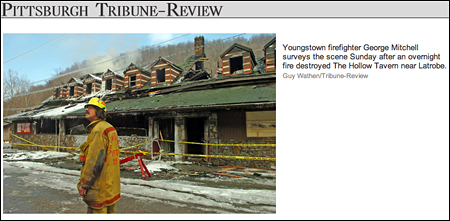
I have three updates on Sleepy Hollow Tavern near Ligonier, Pennsylvania, a 1939 roadside landmark along the Lincoln Highway that burned in February.


An article in today’s Tribune Review reports that the contractor demolishing and rebuilding the place has found numerous treasures including a couple huge safes. Fred Haeflein says one of the safes is a 100-year-old, 1,000-pound combo-lock model, hand-painted with gold lining and braided metal on the outside. Other items include a popcorn machine, brass lighting fixtures, a Corona metal beer cooler, and objects that hung on the walls such as antique skis, golf clubs, and “various Lincoln Highway road signs.”
The Trib also recently reported that Ligonier filmmaker Andrea Niapas, who produced a 2007 docudrama of Amelia Earhart’s last flight, is documenting Haeflein as he dismantles and rebuilds the tavern. She sometimes stands atop construction vehicles to get better footage of the building’s selective demolition.
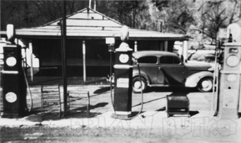
Finally, Clinton Piper wrote to say that his mother volunteers to compile obituaries for a local database and was searching the Latrobe Bulletin on microfilm when she came across some interesting references to two buildings on the Sleepy Hollow site:
1. Overland Inn burned prior to 1926
2. Gas station destroyed by fire 10/18/26
A later gas station at the site is pictured in my PA LH book (shown above) but little is known about it.
Tags:fire, Ligonier PA, roadside tavern, Sleepy Hollow
Posted in highways, history, lodging, roadside | Leave a Comment »
July 16, 2008

As Buddy and Bob pulled their Piaggio MP3 scooters into Times Square on Monday, ending their coast-to coast drive across the Lincoln Highway, reporters lined up to interview them. Their arrival was covered by The New York Times, Forbes, CNN, New York Daily News, NY Metro, and others, including a number of blogs. Buddy and Bob were nice enough to mention to the NYT that they used my Greetings from The Lincoln Highway as their travel guide.


LHA director for New York Jerry Peppers was there to greet them and provided the photos above and these observations:
Piaggio’s marketing people got a police escort so we could occupy the NW corner of Broadway and 42nd Street for a half hour or so without being harassed by traffic. They also arranged for media coverage and I was personally interviewed and talked about trying to get a bronze plaque to mark the eastern terminus on the building corner that was only about ten feet from where we were standing.
I took the paper sign that I had previously attached to the post on the corner where we are endeavoring to get a permanent sign post and pasted it there again for this event. The second photo shows Bob Chase on his bike next to that temporary marker. The Piaggio people produced a hand-held sign that found its way into many photographs as well.
I talked to both riders at some length, particularly Buddy who is a New Yorker. They were appreciative of meeting the LHA members in Evanston and the treatment they got. Also, Bob Chase has joined the LHA and actually carries his membership card! He lives in Livermore in the Bay area.
Here’s a screen shot from the NYT story:
Tags:cross-country trip, eastern terminus - Lincoln Highway, New York City, Piaggio cycles/scooters, Times Square
Posted in highways, Road trip, transportation, travel | Leave a Comment »
July 15, 2008
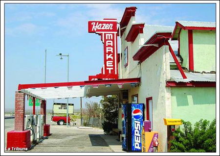
Hazen Market, a well-known stop east of Reno, Nwevada, has closed after some 70 years in business. A report in the Lahontan Valley News says the recent widening of US 50A made it difficult for travelers to stop, leading to a decline in business. The store was originally along the old Lincoln Highway but was relocated in 1944 when the railroad and highway were moved to bypass south of the little town. Producer Rick Sebak stopped last year on his first trip for the upcoming PBS special and, like so many, enjoyed his visit.
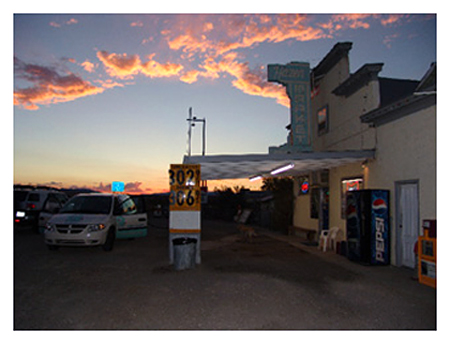
The market had been spruced up since then (as seen in Rick’s sunset photo above versus one from the article below). It still maintained its classic appearance, but that was not enough according to the article, excerpts of which follow.
Owner Allen Hughes blames the Nevada Department of Transportation for the store’s demise…. “The State of Nevada blocked me off,” he said, adding he was promised three turning lanes, which never materialized.
People traveling from Fernley would have to drive 300 feet past the market and make a U-turn to enter his business and make another U-turn when exiting the store because there is no turn lane when traveling eastbound….
Hughes said he is not sure of what he will do with the building, but has thoughts of turning it into a delicatessen/bar to make it more of a destination business than a convenience. He said people who would not stop for a soft drink might do so for a sandwich.
Hughes said the store is for lease, and is willing to work with interested people who would like to open some type of business there.
Hazen residents said they are being affected by the closing of the market, which is located halfway between Fallon and Fernley.
Tags:Hazen NV, highway progress, old-time grocery, vintage convenience store closes
Posted in food, highways, history, roadside, transportation, travel | Leave a Comment »
July 14, 2008
LancasterOnline reports that more retail may be coming to the busy Lincoln Highway/US 30 corridor east of Lancaster, Pa. This stretch was still rural until about WWII, then grew modestly along with interest in the Amish who live in the area. Living history farms, country-style buffets, and other Pennsylvania Dutch-themed businesses dotted the road till the early 1990s when the city pursued businesses that operated beyond daylight hours. Wal-Mart was among the first to open (on the former Amish Homestead attraction) and now outlet malls, strip malls, and fast food chains dominate the multiple-lane highway.

Many of the old hotels are gone, which is apparently what this development would replace — the former c. 1960 Congress Inn, seen above in May.
[Lancaster County Planning Commission[ planners are expected to review plans for the Millcreek Square shopping center proposed for 35 acres on Lincoln Highway East in East Lampeter Township.
Affiliates of High Real Estate Group LLC and Faison Enterprises Inc., of Charlotte, N.C., are planning a 287,000-square-foot center adjacent to Lancaster Host Resort.
The main entrance to the center would be opposite the entrance to the complex where Applebee’s Neighborhood Grill and the Italian Villa are located.
Smaller retailers would be located along Lincoln Highway East, while midsize and large stores would form an “L” shape along the east side and rear of the property.
Developers have declined to name any retailers that might occupy the complex.
Tags:Lancaster, old motel, shopping over-development, sprawl, US 30
Posted in highways, history, lodging, roadside, travel | Leave a Comment »
July 11, 2008
After 3,400 miles but just $300 in gas on their Piaggio cycles, Buddy Rosenbaum (71) and Bob Chase (72) are set to reach the eastern terminus of the Lincoln Highway on Monday, July 14. Scooter commuters and the New York Scooter Club will welcome them to Times Square, which will close briefly just for them!
You can greet them too – here’s the schedule:
9 am — Breakfast at Vespa Jersey City.
10 am — Ride via the Lincoln Tunnel (a later LH route) into NYC.
10:30 to 10:45 am — Welcome at Times Square, 42nd and Broadway.
11:45 am to 2 pm — Reception and lunch at Bond 45, 154 W. 45th St.
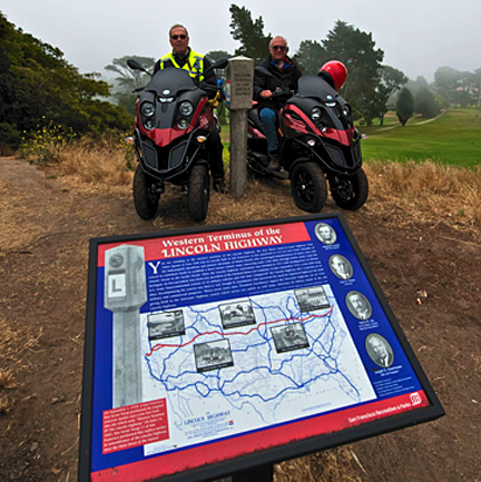
Above: Bob, Buddy, and their Piaggios in San Francisco at the western terminus. Read more at www.noagelimitpiaggio.us/.
Tags:cross-country trip, Piaggio scsooters, San Francisco, Times Square celebration
Posted in highways, history, Road trip, transportation, travel | 1 Comment »
July 11, 2008
I’ll be talking about roadside attractions today (Friday, July 11) on Sirius satellite radio with Meredith Ochs. You can catch it on ROAD DOG 147 / OUTLAW COUNTRY 63 from about 11:15 till noon EDT. Both our roadside books include many Lincoln Highway attractions; in fact, the cover of Roadside Giants features a view looking east on the Lincoln Highway at Fossil Cabin in Wyoming.


You can click the covers if you’d like to order or just learn more about them on Amazon.
Tags:roadside attractions, roadside giants, Sirius radio interview
Posted in highways, history, Road trip, roadside, travel | Leave a Comment »
July 10, 2008

Folks across Iowa continue to suffer from the storms and flooding of a few weeks ago, at a scale incomprehendible to us outsiders. Cedar Rapids alone had 1,300 city blocks under water! J.R. Manning sent links to photos that Iowa DOT took at the time, many showing US 30 where it is either atop or near the Lincoln Highway. Above and below are a few or click here for the complete galleries. Here’s an update on current conditions from Van & Bev Becker:
The Cedar River cuts through the center of Cedar Rapids with the government buildings on an island in the center of town. The 1st Ave Bridge ( 1913-1916 route of the LH) was totally under water including the railings. The 2nd Ave Bridge (1916-1928 route of the LH) was also totally under water including the railings. At the flood peak, ALL bridges in Cedar Rapids, including I-380, were closed. One railroad bridge, loaded with freight cars, washed away. The city government and county government offices are now scattered all around town. Today, all bridges are again open to normal traffic. There are huge piles of flooded and damaged carpet, desks, furniture, files, food, coolers, etc lining the downtown streets and lower neighborhoods.
How did the Lincoln Highway sites and landmarks fare? Quite well thank you.
• The beautiful Coe College campus where we held our natl LHA conference 2 years ago (2006) escaped any flood damage.
• The 1st and 2nd Ave Bridges over the river are back to normal use.
• The huge Grant Wood stain glass window, in the Veteran’s Memorial Building – north side of the 2nd Ave bridge – shows a few cracks and a bit of bowing. This historic treasure can be repaired.
• The Maid Rite (loose meat sandwitches) on 1st Ave West – 6 and a half blocks from the river – was under water to the ceiling. Everything inside is a loss. It is too soon to know if this small business will survive.
• The 1927 Roosevelt Hotel on 1st Ave and 2nd Street is still closed, no power yet. Water filled the basement and first floor.
• The Quaker Oats production facilities (largest cereal mill in the world ) will be closed for a few months. They had water up to the second flood in places. The surrounding railroad tracks and lack of power will be a problen for too but they will reopen.
• There were no LH markers (other than painted telephone poles) affected.
• There were no LH kiosks affected.
• There were no LH road signs affected.
• The Iowa LHA chapter is still going ahead with our 3-day motor tour (Aug 8-9-10) crossing the state with the first overnite stop in Cedar Rapids.
• Highway 30, I-80 and the mainline of the Union Pacific Railroad are all reopened and flowing as normal.
It will be 5-10 years before the city fully recovers from a 500-year flood. We are working hard and fast – by the end of the summer a quick casual tourist may never spot evidence of the flood.


Tags:Cedar Rapids Iowa, flooding, highways impassable, Iowa
Posted in highways, transportation, travel | Leave a Comment »