Archive for November, 2008
November 27, 2008
For weeks I’ve been proofreading a design draft of my next book, Lincoln Highway Companion. Though I’d like to think I sent off a masterpiece, corrections from my editor and volunteer readers proves that there’s always room for improvement.

The 15 or so readers have caught misspelled words or street names that have changed or found listings for places that have closed. The maps were only half done, being that they were such a massive part of the project, so they are receiving tons of additional info—street names, landmarks, geographic feature notations, and letters keyed to Must-See attractions.
Hardest to take are the businesses that were included that have since closed. I’m not only sad for the effort that I (or guest writers) put into those stories, but the road is one bit less interesting each time a place closes or is demolished.
I’m proofing so many different aspects, and comparing to so many original sources and maps, that it’s eating away weeks of free time. I’ll be taking a few days now at Thanksgiving to try to finish it.
Tags:book underway, Lincoln Highway, Lincoln Highway Companion, proofreading my book
Posted in food, highways, history, lodging, Road trip, roadside, signs, transportation, travel | 2 Comments »
November 25, 2008
Sylverta Blaugher writes:
Bought several of your books this summer as my husband and I were traveling Route 30 West [Lincoln Highway] from Chambersburg Pa. I was raised in C’burg but married and moved to Ft Wayne 40 years ago.

I lived with my Great Aunt Pearl and Great Uncle Harry during the summer months in the late 1950s and early ’60s. They owned the Cove Mountain Tea Room that is in your book The Lincoln Highway: Pennsylvania Traveler’s Guide, pages 183-184.
The house is gone and the garage that is still standing was used as an antique store that they operated. My Mother lived with them in the ’40s after they bought the property. She often talked of buses stopping there and serving sandwiches. After Aunt Pearl had a stroke they stopped serving but they still sold Shell gas and had a small store where they sold pop and candy.
My Mother still lives in Chambersburg and going thru my Grandmother’s papers that she has I am always searching for any articles regarding when they bought the property and any menus etc, but I have not yet found any. I do have pictures of us on the top of the roof and many great family picnics.
I still miss the mountains and when I go home I sometimes get off at Breezewood so I can relive old memories of days gone by. Never had the fear of roaming the mountains like I do today.
Keep up the good work so the rest of the travelers can read of places that are no longer there to see.
Tags:cinrtage gas pumps, family-run business, Lincoln Highway, mountaintop stop, roadside attraction, tea room
Posted in food, highways, history, Road trip, roadside | 2 Comments »
November 24, 2008
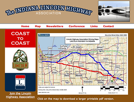
The cover to The Lincoln Highway across Indiana has been released, showing a classic view of one of the Lincoln Highway’s cast-iron state line markers—this one at the Illinois border. The book was written by Jan Shupert Arick for the state’s LHA chapter. It will retail for $21.99 when published in Spring 2009.

Tags:auto history, early automotive, highway history, Indiana, Lincoln Highway
Posted in highways, history, Lincoln Highway, roadside, transportation, travel | 1 Comment »
November 21, 2008
Ibapah is along the original Lincoln Highway that crosses the Utah desert between Salt Lake City and Ely, Nevada. You’ll need most of a full day to drive the dirt roads between those points but you’ll also see Orr’s Ranch, Fish Springs, Gold Hill, and other unpopulated outposts.

The Ibapah Trading Post is bound to become one of the Lincoln Highway’s must-stops, much like Oatman, Arizona, draws travelers to a desolate part of Route 66. I’ve been corresponding with Carolee Johnson at the post in anticipation of my next book, Lincoln Highway Companion. The big news is they now have a cabin for rent along with the old country store.

Carolee wrote:
We are trying to make this stop on the Lincoln Highway a little more inviting as funds become available, and people are welcome to stop through in June to watch real Western Cowboys rope and brand the livestock, and check out a real Old West ghost town. The buildings in the town are all still there as it was at one time the main stop for the overland stage between Chicago and Sacramento. There are stories of bandits coming to rob gold, mined out of the Queen of Sheba Gold Mines, out of the safe in the store where it waited for the overland stage. Efforts were foiled when the store owner was tipped off and hid the bars of gold in the ashes of the old pot belly stove. We still have the safe that was rolled out and blown up with dynamite by the bandits. Needless to say they didnt get the gold. This stop on the Lincoln Highway is teaming with US history and deserves to be on the map. I very much appreciate what you are doing for the history of the Lincoln Highway, and hope this helps a little.


Tags:ghost town remnants, highway history, Ibapah UT, lonely outpost, Route 66 -Oatman AZ, Utah, Wild West
Posted in food, highways, history, lodging, Road trip, roadside, transportation, travel | Leave a Comment »
November 20, 2008
I’m glad to report on a couple new beautiful books, even if their subjects aren’t along the Lincoln Highway.

It’s hard to believe there are as many beautiful vintage gas stations left in the entire US as there are in Wisconsin alone, but Fill ’er Up proves you can still find dozens. After a solid and fun introduction, 59 stations are examined: Classical, canopy, cottage, deco, moderne, futuristic, they’re all here. Many still pump gas, and most still look like they would have decades ago. The authors take the extra step of uncovering the stories behind each one. Stunning photos plus old snaphots, postcards, and blueprints make for a truly impressive book.

I loved National Lampoon’s True Facts books that featured humorous road signs and billboards but that was 20 years ago. For those who’ve needed their fix, Funny Signs by RoadTrip America (that’s Mark Sedenquist and Megan Edwards) is a wacky collection of unintentionally hilarious wordings. The “Ronald McDonald Funeral Home.” “Lunch Specials, We Have Worms.” “Fire Exit, Employees Only.” There’s a “Dead End” sign on “Opportunity Way.” The difference here is that the authors add a short comment each time. So a sign that says “Don’t touch the actors” begs the question ‘What about the actresses?” Or “Urgent Care Coming Soon” leads to “Take two aspirin and stretch out in the parking lot.” You can’t believe that page after page there are so many goofy signs out there. Buy it — and you might just recognize a Lincoln Highway motel sign.
Tags:books, funny signs, gas stations, humorous book, roadside books, vintage filling stations, Wisconsin
Posted in highways, history, Road trip, roadside, signs, travel | 2 Comments »
November 19, 2008

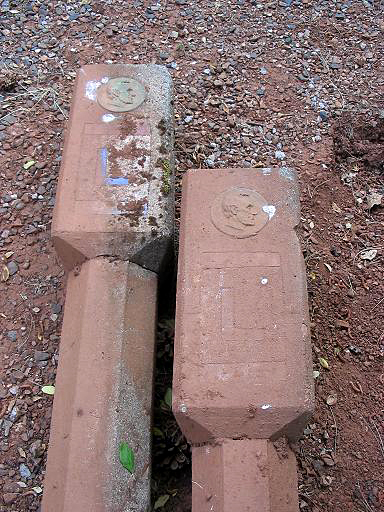
Two long-lost Lincoln Highway markers were unearthed recently in California. They are two of the concrete posts planted along the road in 1928 as a final memorial to Lincoln and the road named for him. LHA president Bob Dieterich explains:
I got an email from Lee Hollifield saying he had two “Lincoln Highway posts.” He didn’t want them resold, but wanted them put on display and his father-in-law, Ray Helm, given credit as the donor. Everybody agreed that the California Chapter of the LHA should take possession. Norm Root and Lloyd Johnson and I drove up to Camino (on the Pioneer Branch of the LH near US 50) to see them. Beside his driveway were the two posts, barely recognizable because of all the red volcanic soil that had leached into the concrete.
Ray had half-interest in a salvage yard and when he and his partner dissolved the business about 20 years ago, they each took what they wanted. There were four posts; we think two of them ended up at the entrance to the El Dorado County museum at the county fairgrounds in Placerville. Ray took the other two home and laid them beside his driveway. Over the years they literally sunk into the ground. Lee dug them out of the ground and they decided to donate them somewhere. They are now at Norm Root’s house waiting restoration. Both are cracked, but Norm can perform miracles on concrete.
At our last California chapter meeting, we voted that one of them should end up in the Folsom History Museum. Folsom is also on the Pioneer branch and the museum is a logical place to display them while being protected from vandalism.

The top photo shows Norm Root and Lloyd Johnson standing by the markers as we found them. The second photo shows the markers being loaded into the back of Norm Root’s Suburban.

The third photo shows the posts being pressure washed in Norm’s driveway.
You can also read about it from the donor’s perspective HERE, and here is one some of his images:

Tags:buried markers unearthed, California, Camino CA, highway history, highway markers
Posted in highways, history, museum, roadside | 3 Comments »
November 18, 2008
Inspired we hope by our post of last Tuesday, Spiny Norman followed later that day with his first-person impressions and recollections of the Olympia Candy Kitchen. Spiny’s blog, Goshen’s Lincoln Highway, explores the route through that Indiana city and the places along it. It’s a great idea about an area with lots of neat places to see. Yesterday’s post investigated an old alignment south along US 33.

Tags:chocolate store, Goshen IN, Indiana history, Lincoln Highway, roadside business, soda fountain
Posted in food, highways, history, roadside, travel | 2 Comments »
November 14, 2008
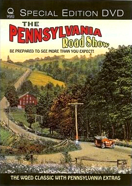
 New on DVD from PBS affiliate WQED is producer Rick Sebak’s 1992 program, The Pennsylvania Road Show. This video includes my original trip with Rick on the Lincoln Highway east of PIttsburgh, 15 years before he set out to film his national Lincoln Highway show that just debuted.
Driving in my Camaro convertible, we cruised to Shirey’s Cabins, the Ship Hotel, and other Lincoln Highway landmarks – many, including those two, now gone. Sebak also visits Lee’s DIner and the Shoe House, both along the Lincoln Highway near York. On the cover is a 1920s Lincoln Highway postcard.
Also featured are visits to Reptileland, movie cowboy Tom Mix’s birthplace, and the ducks walking on fish at the Linesville Spillway. The DVD is available from WQED for $19.95.
Tags:Lincoln Highway, PA Road Show, PBS-related video, roadside attractions, Ship Hotel, WQED
Posted in food, highways, history, lodging, Road trip, roadside, travel | Leave a Comment »
November 13, 2008
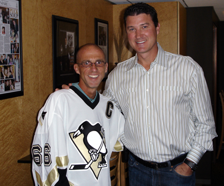
Piil Rosenstein is nearing the end of his cross-country run, mush of which followed Route 66 and since Illihios has often been on the Lincoln HIghway. He wrote the note below from York, Pa. He’ll follow US 30 to the coast, meaning at Philadelphia he’ll leave the Lincoln, which bends NE to New York City. His running supports the charity of The Mario Lemieux Foundation which works in cancer research and supporting families affected by cancer. Here are excerpts from his diary starting in Pittsburgh:
Nov 6 = I gave a few more interviews and met a few former Penguins who are now announcing games. And I met the current best player in the world – Sidney Crosby…. 10 minutes into the first period they had a very nice ceremony with a video tribute to me on the jumbotron where I was presented with a couple of gifts. I received a proclamation from the mayor of Pittsburgh that November 6th, 2008, was Official Phil Rosenstein Day for the city…. After that, we went up to the owner’s box where I got to meet the owner himself – Mario Lemieux. What more can I say??

Nov 7 = I stopped in Greensburg for a free milkshake around noon because they recognized me from the TV…. I never would have made it to Greensburg without Dan’s help by taking the stroller [cart] from me. The shoulder came and went often and all the traffic would have been within inches of hitting me had I been out there with that stroller…. I made it to the edge of Laughlintown before stopping for the night.
Nov 8 = The temperature today was 49 degrees to start and then never got any higher. Part of that is due to the amount of time I spent climbing a few mountains today. Though they were only 2900 feet high, it still isn’t easy pushing that stroller up them…. I took a picture of one of the more beautiful Lincoln Highway (Route 30) murals. I ran about 40 miles again today and ended up getting into Schellsburg just as it got dark.

Nov 9 = I left Schellsburg feeling a bit sore from all the recent miles and the hills, but I still made good time getting into Bedford where I met up with Alisa and here friends Sue and Peter. I spent all day running without the stroller, but with two people while the third waited five miles ahead for us. It was weird to run with other people, but I really enjoyed the company and made good time running a steady pace all day. We finished the day about 13 miles east of Breezewood. By running without the stroller and the hydration vest, I was able to finish the day with more than 40 miles once again – third day in a row.
Nov 10 = I ran 40 miles once again today. That’s 4 days in a row now. My legs can feel it now. I was pretty sore all day long and really struggled in the afternoon. In the morning, I went over a few more mountains where it was snowing on top. It’s much easier without the stroller (left behind at Alisa’s place) going up a mountain. Going down is where it hurt the most. After that it was flat, but the winds made it seem colder than the 35 degrees the thermometers kept saying. I finished the day in Caledonia tired, sore, and freezing cold.
Nov 11 = Alisa dropped me off where she picked me up last night, but this time I had the stroller. I moved slowly since I was sore and tired from all the recent miles. I made it through Gettysburg (on this Veteran’s Day) and then another 10 miles before meeting my friends Dave and Gary who drove up from Virginia. We … made it to the edge of York before going out to dinner.
Tags:Bedford PA, Breezewood PA, Greensburg PA, Mario Lemieux, Penguins hockey, Pittsburgh Penguins, Running across America, York PA
Posted in highways, history, travel | Leave a Comment »


 New on DVD from PBS affiliate WQED is producer Rick Sebak’s 1992 program, The Pennsylvania Road Show. This video includes my original trip with Rick on the Lincoln Highway east of PIttsburgh, 15 years before he set out to film his national Lincoln Highway show that just debuted.


