Archive for the ‘roadside’ Category
July 25, 2008
The Grand Island Independent reports that Shady Bend, a popular Lincoln Highway attraction on the east end of Grand Island, Nebraska, is being partially revived.

The mostly-cleared site has been bought by Craig Woodward, a grandson of founder H.O. Woodward. All that remains from the once-thriving site at US 30 and Shady Bend Road is the former Spanish-Revival gas station, which has been a tavern in recent decades. Still, the Shady Bend Gas Station, Grocery and Diner is listed in the National Register of Historic Places, and so Woodward, his wife Karen, and their daughter Jennifer Drapel are working to reopen the bar and restaurant. The business was started in 1929 and grew to include gas, food, and lodging in more than 30 tourist cabins, but the most famous of its attractions was a buffalo herd:
“I grew up thinking that everyone had buffalo in their yard,” Craig said.
He soon realized his grandfather and father’s diner was more than the average family business.
“Everyone I run into is excited to bring this place back,” he said. “They remember the buffalo, they remember eating there and hanging out there.”
For the past few years, the Shady Bend has been rented or vacant. Craig took sole ownership at the beginning of the year.
“We truly would like to have a gathering place again,” he said.

The state LHA newsletter “Linc” Across Nebraska has an in-depth story on it in its July 2008 issue by Lenore Stubblefield, who also provided the top image. She recalls a playground, sandy beach lake, tile tennis courts, and the restaurant’s most expensive meal, a T-bone stteak for 65¢. The cabins (later apartments) closed in 1981, The station was luckily spared in 1994 and 2004 road widenings, and will again be serving travelers.

Tags:buffalo farm, Grand Island Nebraska, Nebraska, roadside attraction, Shady Bend, vintage gas station
Posted in food, highways, history, roadside, travel | 2 Comments »
July 22, 2008
A free Lincoln Highway BUY-WAY Yard Sale Travelers Guide is being distributed along the different routings of the Lincoln Highway through Ohio. The fourth annual BUY-WAY Yard Sale will take place August 7, 8 and 9. The guide features a map of all Lincoln Highway alignments and towns in Ohio, plus contains listings and ads for more than 50 of the larger group events. Guides can be found at participating businesses such as restaurants, attractions, and convenience stores.

Ohio Lincoln Highway Historic Byway Executive Director Mike Hocker says, “The guide is very helpful since many people are confused about where the Lincoln Highway ran — it did change alignments through the years from 1913 to 1928.”
In the 1920s, much of the old route in Ohio was marked US 30 but modern 4-lane improvements bypass the old towns and alignments. That means Ohio alone has roughly 350 miles of yard sales, community events, and festivals with lots of food, drink, and fun for kids. Last year saw more than 700 individual and organizational sales just in Ohio. Indiana and Illinois are participating too, and West Virginia’s 2.25-mile segment of the highway through Chester is also part of the BUY-WAY sale.
More information and a printable listing of yard sales and locations can be found at http://www.historicbyway.com (updated frequently). To get your guide ahead of time by mail (free for the price of a SASE), visit the travel guide page.
Tags:Buy Way yard sale, highway yard sale, map guide to sales, Ohio, yard sales
Posted in food, highways, history, roadside, travel | 1 Comment »
July 21, 2008
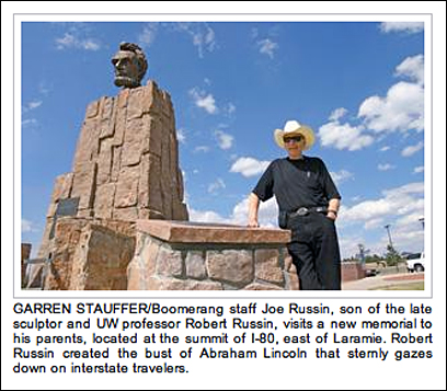
The Laramie Boomerang reports that the ashes of sculptor Robert Russin and his wife Adele have been interred at the monument he created in 1959 to honor Lincoln’s 150th birthday. Its location in eastern Wyoming marked the highest point on the transcontinental Lincoln Highway: 8,835 feet. In 1969, the monument was moved to the nearby Summit Rest Area (exit 323) when I-80 opened between Cheyenne and Laramie, and is now at the highest point along I-80: 8,640 feet.
Above is a screen shot from the article and here’s a bit of the story:
Joe Russin, one of the sculptor’s sons, said his father’s wish was to be laid to rest near the statute [sic].
“The Lincoln statute became his calling card,” Russin said. “It was one of his favorite statutes.”
The mighty statute was actually made in Mexico City and then brought, in pieces, to Wyoming….
“My dad hadn’t thought about how low the wires were over Grand Avenue,” Russin said. “So they had to move it through Laramie really early in the morning and they cut the electric and telephone wires for each block as they went through.”

ABOVE: Sculptor Robert Russin and assistants work on the bust of Abraham Lincoln. Courtesy Jim Kearns, Manager, University of Wyoming Media Relations.
Tags:Abraham Lincoln sculpture, highway monument, Laramie Wyoming, memorial, rest area, sculpture, Wyoming
Posted in highways, history, roadside, transportation, travel | Leave a Comment »
July 18, 2008

We spent last night under a rising full moon at the Twin Hi-Way Drive-In, named for the two roads passing by: the Lincoln Highway and Wm. Penn Highway (later US routes 22 & 30). Opened in 1950 in suburban Pittsburgh, the “drive-in capital,” it had closed in 1996 and sat mostly vacant, hosting volleyball tounaments for the adjacent bar and military-themed haunted attractions at Halloween. Three local partners – Jerry Salnoris, Dan Tice, and Jim Torcasi – reopened it last July 3. Business is OK but they have the usual challenge of rainy weather and that most profits go back to the movie distributor, so they depend greatly on snack bar sales. We did our part with endless trips for drinks, ice cream, french fries, and popcorn!


Visit your local drive-in this weekend to experience a movie under the stars. Their land is always tempting to developers so let’s support them while we can. Check the list at right for a LH drive-in near you or send any I might have missed.
Twin Hi-Way Drive-In
5588 Steubenville Pike
Robinson Township, PA
(412) 494-4999
http://www.twinhiwaydrivein.com
Tags:drive-in theater, family fun, old business still viable, ozoner
Posted in food, highways, history, roadside, transportation, travel | 3 Comments »
July 17, 2008
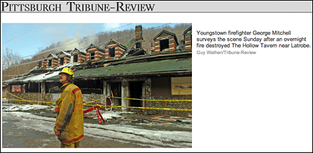
I have three updates on Sleepy Hollow Tavern near Ligonier, Pennsylvania, a 1939 roadside landmark along the Lincoln Highway that burned in February.


An article in today’s Tribune Review reports that the contractor demolishing and rebuilding the place has found numerous treasures including a couple huge safes. Fred Haeflein says one of the safes is a 100-year-old, 1,000-pound combo-lock model, hand-painted with gold lining and braided metal on the outside. Other items include a popcorn machine, brass lighting fixtures, a Corona metal beer cooler, and objects that hung on the walls such as antique skis, golf clubs, and “various Lincoln Highway road signs.”
The Trib also recently reported that Ligonier filmmaker Andrea Niapas, who produced a 2007 docudrama of Amelia Earhart’s last flight, is documenting Haeflein as he dismantles and rebuilds the tavern. She sometimes stands atop construction vehicles to get better footage of the building’s selective demolition.
Finally, Clinton Piper wrote to say that his mother volunteers to compile obituaries for a local database and was searching the Latrobe Bulletin on microfilm when she came across some interesting references to two buildings on the Sleepy Hollow site:
1. Overland Inn burned prior to 1926
2. Gas station destroyed by fire 10/18/26
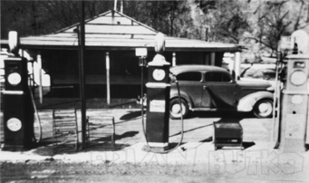
A later gas station at the site is pictured in my PA LH book (shown above) but little is known about it.
Tags:fire, Ligonier PA, roadside tavern, Sleepy Hollow
Posted in highways, history, lodging, roadside | Leave a Comment »
July 15, 2008
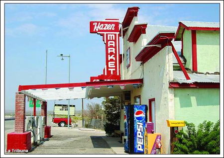
Hazen Market, a well-known stop east of Reno, Nwevada, has closed after some 70 years in business. A report in the Lahontan Valley News says the recent widening of US 50A made it difficult for travelers to stop, leading to a decline in business. The store was originally along the old Lincoln Highway but was relocated in 1944 when the railroad and highway were moved to bypass south of the little town. Producer Rick Sebak stopped last year on his first trip for the upcoming PBS special and, like so many, enjoyed his visit.
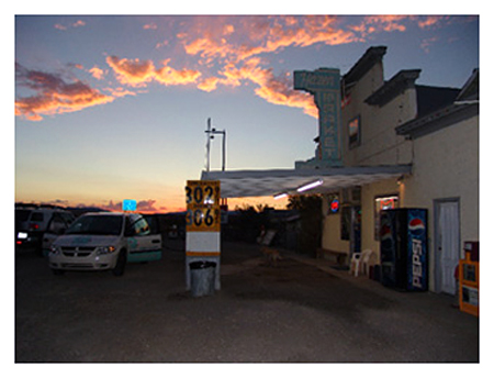
The market had been spruced up since then (as seen in Rick’s sunset photo above versus one from the article below). It still maintained its classic appearance, but that was not enough according to the article, excerpts of which follow.
Owner Allen Hughes blames the Nevada Department of Transportation for the store’s demise…. “The State of Nevada blocked me off,” he said, adding he was promised three turning lanes, which never materialized.
People traveling from Fernley would have to drive 300 feet past the market and make a U-turn to enter his business and make another U-turn when exiting the store because there is no turn lane when traveling eastbound….
Hughes said he is not sure of what he will do with the building, but has thoughts of turning it into a delicatessen/bar to make it more of a destination business than a convenience. He said people who would not stop for a soft drink might do so for a sandwich.
Hughes said the store is for lease, and is willing to work with interested people who would like to open some type of business there.
Hazen residents said they are being affected by the closing of the market, which is located halfway between Fallon and Fernley.
Tags:Hazen NV, highway progress, old-time grocery, vintage convenience store closes
Posted in food, highways, history, roadside, transportation, travel | Leave a Comment »
July 14, 2008
LancasterOnline reports that more retail may be coming to the busy Lincoln Highway/US 30 corridor east of Lancaster, Pa. This stretch was still rural until about WWII, then grew modestly along with interest in the Amish who live in the area. Living history farms, country-style buffets, and other Pennsylvania Dutch-themed businesses dotted the road till the early 1990s when the city pursued businesses that operated beyond daylight hours. Wal-Mart was among the first to open (on the former Amish Homestead attraction) and now outlet malls, strip malls, and fast food chains dominate the multiple-lane highway.

Many of the old hotels are gone, which is apparently what this development would replace — the former c. 1960 Congress Inn, seen above in May.
[Lancaster County Planning Commission[ planners are expected to review plans for the Millcreek Square shopping center proposed for 35 acres on Lincoln Highway East in East Lampeter Township.
Affiliates of High Real Estate Group LLC and Faison Enterprises Inc., of Charlotte, N.C., are planning a 287,000-square-foot center adjacent to Lancaster Host Resort.
The main entrance to the center would be opposite the entrance to the complex where Applebee’s Neighborhood Grill and the Italian Villa are located.
Smaller retailers would be located along Lincoln Highway East, while midsize and large stores would form an “L” shape along the east side and rear of the property.
Developers have declined to name any retailers that might occupy the complex.
Tags:Lancaster, old motel, shopping over-development, sprawl, US 30
Posted in highways, history, lodging, roadside, travel | Leave a Comment »
July 11, 2008
I’ll be talking about roadside attractions today (Friday, July 11) on Sirius satellite radio with Meredith Ochs. You can catch it on ROAD DOG 147 / OUTLAW COUNTRY 63 from about 11:15 till noon EDT. Both our roadside books include many Lincoln Highway attractions; in fact, the cover of Roadside Giants features a view looking east on the Lincoln Highway at Fossil Cabin in Wyoming.


You can click the covers if you’d like to order or just learn more about them on Amazon.
Tags:roadside attractions, roadside giants, Sirius radio interview
Posted in highways, history, Road trip, roadside, travel | Leave a Comment »
July 4, 2008
Diane Rossiter of the Illinois Lincoln Highway Coalition sent an update as Buddy and Bob crossed Illinois on their Piaggio cycles:
 Here’s a photo of Buddy and Bob (posing as one of the pioneering motorcycling Van Buren sisters) in the Dixon Welcome Center. They stopped here on Thursday, July 3rd, to visit the Lincoln Highway Interpretive Center. We lunched at The Salamander in downtown Dixon with Mayor Jim Burke and Diane Bausman, Executive Director of the Blackhawk Waterways Convention & Visitor Bureau.
 This is the signage at the new location of the Dixon Welcome Center on the corner of River and Galena Streets. It houses a Lincoln Highway Interpretive Exhibit. The center opens Mon – Sat at 10 a.m.
 Buddy, Bob, and I then stopped in Franklin Grove to visit the LHA Headquarters where they bought a couple of shirts from Lyn Asp. While there, they sat for 5 minutes and conducted an interview via cell phone with a lady named Karin who was reaching them from France. They are making news worldwide now! They are really nice gentlemen and are full of stories from all of their travels of the world.
From here we drove through Ashton, Rochelle, and stopped at the Seedling Mile Marker in Malta, Illinois. We couldn’t stay long, as they had a press conference in DeKalb. There, they were greeted by two legislators, the mayor of DeKalb, and several reporters. They were presented with several area gifts and ILHC gave them each an embroidered shirt with our logo on it. Tomorrow, they drive on to Plainfield and further east. The big trips ends at Times Square on July 14th.
Tags:Illinois travel, Piaggio cycles, Road trip
Posted in highways, history, museum, Road trip, roadside, travel | Leave a Comment »