Archive for the ‘roadside’ Category
November 25, 2007
Like the Mystery Photos we sometimes run on weekends, there are likewise lots of postcards that we wonder “whatever happened to that place?” This beautiful linen card from the Curt Teich Company pictures the Country Club Motor Lodge and Coffee Shop, 2665 Parley’s Way, Salt Lake City, Utah. It advertised 55 “strictly modern units” and “Sun Porch and Modern Coffee Shop for Convenience of Guests.” It’s named for The Country Club across the road, one of the West’s oldest courses (founded 1899) and still an elegant, private 18-hole course. Today, housing separates the two just west of the tangle of ramps where I-80, I-215, and UT 186 meet.

This card, postmarked Aug 4, 1949, was sent by a child:
“We got here right today We will be back to Sacramento California soon We are haveing a nice trip so good-by and I will see you soon from Mary Jean”

What’s left at the site today? The phone number is now a private residence. A Yahoo aerial view shows it still there, but you can buy for a condo at the Country Club Ridge subdivision at the same address. Price for #310 is $649,000 for 2,065 sq ft, built 2007. Are we a year too late…?

Tags:Country Club, highway, lodging, motel, Road trip, roadside, Salt Lake City, travel, Utah
Posted in highways, history, lodging, Road trip, roadside, travel | 2 Comments »
November 24, 2007
The Iowa Lincoln Highway Association is organizing its first-ever River to River Motor Tour across Iowa for August 8-10, 2008. All cars are invited, and classic car owners can rest easy that no gravel alignments will be on the official route. Participants can join or leave the tour at any point.

Above: The newly wiidened bridge between Omaha, Nebraska and Council Bluffs, Iowa, 1924. (Univ of Michigan, Special Collections Library, lhc2218)
Starting in Clinton, highlights will include:
• Site of the Lyons-Fulton Bridge in Clinton
• Walk on the abandoned Lincoln Highway west of Lowden
• Restored Youngville Café in Benton County
• World-famous Lincoln Highway Bridge in Tama
• State Center, the “rose capital of Iowa”
• Tour restored Reed/Niland corners in Colo
• Lincoln Highway Clubhouse in Jefferson
• Drive on the brick Lincoln Highway in Woodbine
• Hitchcock Nature Center near Honey Creek
Registration is $20 per vehicle for Iowa LHA members or $30 per vehicle for non-members that registers that person for a one year membership to the Iowa LHA. For more information, visit the Iowa LHA website or contact coordinator LHA Iowa director Jeff LaFollette, who has previously chaired motor tours along Route 66 in Illinois, at jefflaf@peoplepc.com or (563) 349-3047.
Tags:antique cars, bridge, classic cars, Iowa, rally, Road trip, roadside, tour, travel
Posted in food, highways, history, lodging, Road trip, roadside, transportation, travel | Leave a Comment »
November 24, 2007
Leigh and Chuck Henline of Fort Cody Trading Post in North Platte, Nebraska, stopped at the Covered Wagon west of Kearney on their Thanksgiving trip to snap a few photos of the Covered Wagon, previously reported on here. Note the office now has a second story. Here’s a closeup of the wagon, still awaiting restoration:
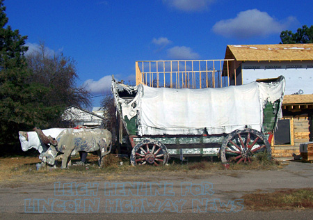
Or click below for a 2-photo panorama of the site. Note the houses rising behind it on what was once the 1733 Ranch:

Tags:attractions, Covered Wagon, Kearney, Nebraska, oxen, Road trip, roadside, Route 30
Posted in highways, history, Road trip, roadside, transportation, travel | 4 Comments »
November 23, 2007
Friday was the last day for a popular DeKalb intitution. A story in the DeKalb Daily Chronicle recounts the history and good times at Ralph’s News Stand & Trophy House, 664 E. Lincoln Highway. Ralph Seats owned and operated the store from 1952 until his death last year at age 83. It was popular with locals but, as the article explained, “With a small number of street parking spots near the store—and an influx of chain stores offering some, but not all, of the same services as the shop—Ralph’s is yet another signature mom-and-pop style shop to shut its doors.”
 Like an old-time general store, Ralph’s carried a bit of everything: “Lock de-icer can be found next to chewing tobacco. Toward the back of the store are rows of cards offering warm praises for birthdays, graduations and other life events. Sitting among chewing gum is an old-fashioned rotary-dial phone with a detachable ear piece connected to a cord … lottery tickets, trophy engraving, Western Union service, tobacco, magazines, newspapers and a tube tester from the years when TVs needed tubes to operate.
Ralph’s first opened in the middle of the 600 block before moving to the corner of Seventh Street and Lincoln Highway. For decades it was open 5 am till midnight. Ralph insisted a big-band radio station be on at all times, which it was—until he left! His widow Doris said it’s hard to close, but “it’s a little more than I can take. It’s sad not having him here. I miss him.”
Photo Ralph’s Magazines by Joe Thorn
Tags:DeKalb, highway, history, Illinois, store
Posted in food, highways, history, Road trip, roadside, travel | 3 Comments »
November 23, 2007
 The black granite used in the Vietnam Veterans Memorial in Washington, D.C., was supplied by a family firm along the Lincoln Highway in Lynwood, Illinois, south of Chicago. According to a recent article in The Times of Munster, Indiana, Rogan Granite (21550 E Lincoln Hwy/US 30, about 1000 feet west of the Indiana border) supplied the granite that carries the names of 58,256 veterans who either died in Vietnam or are listed as prisoners of war or missing in action. Tom Rogan says, “It was a very proud moment for our company and our family…. It was an opportunity for us to show what the region could do in support of our veterans.” The company, with roots back to 1874, was known as Calumet Memorial until 1980, when Tom and brothers Jim and Mick expanded the business.
The article recounts, “As part of the company’s headstone business, Rogan Granite supplied grave markers for veterans in several states. It was during a 1982 trip to Washington—to see which grave marker bids were successful—that Rogan learned of the plans for the memorial.” The bid required black granite because it could polish to a mirrorlike reflective surface and allow etched names to show up as white. The granite actully came from India, was cut and polished in Vermont, and etched in Tennesse, but the Rogan family coordinated the process of providing the 144 panels, each 44 inches wide each, that make up the two walls that are each 246 feet, 9 inches long. The memorial was dedicated on Veterans Day in 1982.
Photo Vietnam Memorial, The Wall, Washington D.C. by ehpien
Tags:Chicago, highway, Illinois, memorial, Vietnam
Posted in highways, history, roadside, transportation, travel | 1 Comment »
November 22, 2007
Police patches are increasingly being collected by those interested in the imagery itself, causing concern that the patches will be used to impersonate an officer. Among the many collectable topics is the Lincoln Highway, particularly patches with a road-related graphic. The patch of the Tama, Iowa, police includes what is perhaps the most recognizable LH landmark, the town’s concrete bridge with the road’s name in its side rails. An article in the Marshalltown Times-Republican says eBay offers thousands of patches daily due to this cross-collectability: “Recently a pair of Tama Police Department patches which features the famed Lincoln Highway bridge along with an older department patch sold for just over $27 for the three. It’s likely both police patch and Lincoln Highway memorabilia collectors drove the price offering on the eBay site.” Most departments do not give patches to collectors, but instead destroy old or worn ones.

The police page for Cairo, Ohio makes clear in big red letters, “Cairo PD is not currently giving away or trading patches.” The patch shows the road and spells out “Lincoln Highway.” The page, which has a LH logo, also recounts the road’s history through town:
“In 1921 Lincoln Highway went through Cairo, which was known as West Cairo at the time, on the former Bucyrus Road. Lincoln Highway was eventually designated as U.S. 30. When U.S. 30 was expanded into a four lane, Cairo was bypassed approximately one half mile to the south. Although U.S. 30 has moved south, historic Lincoln Highway still runs through Cairo.”
Tags:bridge, Cairo, collecting, highway, Iowa, Ohio, patch, patches, police, road, Tama
Posted in highways, history, roadside, transportation, travel | Leave a Comment »
November 21, 2007

Gianofer Fields of Chicago Public Radio is heading west, soon to pick up the Lincoln Highway. Her first stop was in Burlington, Iowa, checking out Snake Alley, aka the World’s Crookedest Street. As she says, “I haven’t even made it to the Lincoln Highway and I’m already having a great time. With about 2000 miles to go on this trip, I’d better pace myself.” Read the first day’s journal (Monday, Nov. 26) or listen to it at the Chicago Public Radio site.
Tags:Burlington, Chicago, highway, Iowa, Road trip, roadside, travel
Posted in highways, history, Road trip, roadside, transportation, travel | Leave a Comment »
November 21, 2007
Ron Warnick’s Route 66 News has an interesting story about the “Joliet Kicks on 66” campaign. That Illinois city is promoting sites along the famous Chicago-to-LA road as explained in a news story. The Kicks web site offers lots of places and things to see, including 5 good-looking, very detailed replica gas pumps. Here’s a snap of the page showing the pump at the intersection of 66 and the Lincoln Highway:

Road buffs know there’s another crossing of the two historic highways. To the west, a later alignment of 66 ran through Plainfield where 66 actually shares the road with the LH. Banners there celebrate the pairing.
Lincoln Highway fans also know that the Lincoln Highway Heritage Corridor in Pennsylvania established a fantastic Pump Parade a few years ago. Along the 200-mile corridor from Irwin to Gettysburg are 22 fiberglass replica 1940s pumps, though differing from these in that they were decorated by artists. Here’s one at Schatzer’s Market, a fruit and produce stand west of Chambersburg:

Tags:Chambersburg, gas pump, highways, history, IL, Joliet, PA, Plainfield, Road trip, roadside, Route 66, travel, vacation
Posted in highways, history, Road trip, roadside, transportation, travel | Leave a Comment »
November 21, 2007
The two developments mentioned yesterday are just a small part of Route 30’s spiraling growth east of Pittsburgh. Concern for the corridor led the Smart Growth Partnership of Westmoreland County to host a 5-day design charrette at the University of Pittsburgh’s Greensburg campus (its home base). The focus was the future of U.S. 30/the Lincoln Highway—how to specifically preserve the rural landscape, revitalize towns, and enjoy the benefits of growth while avoiding clogged roadways, vanishing open spaces, and soaring home prices.
A 4-year study started in 2005 covers 40 miles and 12 municipalities from Pittsburgh’s eastern suburbs to the Laurel Highlands, known to Lincoln Highway travelers for the steep winding road on the west side of Laurel Mountain. A master plan being developed will present a prototype for safe, efficient, attractive, and connecting land use. The finished plan is expected in April 2008, followed by a year of implementation. According to Smart Growth, the project is unique in that a non-profit entity is taking a proactive, collaborative approach to help shape communities.

Above: The Lincoln Highway east of Greensburg, Pennsylvania. With 4-lane US 30 to the right, and houses rising on farmland to the left, how long can this rural roadscape survive?
An article in the Pittsburgh Post-Gazette summarized the concepts developed by the group with help from a team of design professionals, engineers, architects, urban planners and landscape architects:
• Mixed use development with the highest density centered on Route 30.
• Public open spaces providing gathering places throughout the site.
• A gateway at the intersection of Route 30 and Route 981 serving as an “arrival point” to Latrobe and the Laurel Highlands.
• Retaining the Route 30 corridor as a regional connection with parallel roads providing local “circulation.”
• Greenways defining the development areas as well as connecting the rural context of the development.
Visit www.route30plan.com to see the plan, photos, and more information.
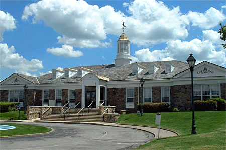
Also from that stretch of US 30/Lincoln Highway, here’s a view of the nice-looking building mentioned in yesterday’s post – the headquarters of the Municipal Authority of Westmoreland County, courtesy of that group via Susan Schmucker, whose brother’s construction company (Dill Construction) built it in 1964. It’s faced in Delaware River sandstone and topped by a metal cupola that conceals the chimney. Cost, including fountain and parking lot, was $312,500 back then. The authority moved out the end of October and it’s set to be demolished. Susan says they outgrew the facility, and traffic had increased dramatically due to retail development, but they will miss it.
Tags:development, Greensburg, growth, highway, Latrobe, Laurel Mountain, Pittsburgh, transportation, travel, US 30
Posted in highways, history, Road trip, roadside, transportation, travel | Leave a Comment »
November 20, 2007
Chesterfields Restaurant, a popular dining choice in North Huntingdon Twp., Pennsylvania, closed recently to make way for a Walgreens drug store and a Starbucks. The Lincoln Highway landmark just west of Irwin (now across from Norwin Shopping Center) opened as the El Dorado in 1934, then for years was the Ben Gross Supper Club, famed for its dinner theater. It had been Chesterfields since 1986, and was one of the last of the region’s legendary dinner spots. According to The Daily News [McKeesport, Oct. 23], with the current owner’s husband passed on and their two sons not interested in a labor-intensive business, they sold to Walnut Capital brokerage firm for $1.5 million. The restaurant was host to many local banquets, celebrations, and Rotary meetings, and until recently had 87 employees. Also likely to be demolished is the adjacent Kirk Haight Auto Sales, best known in years past for having a car atop a pole. See a short video of Chesterfields final day at WPXI.
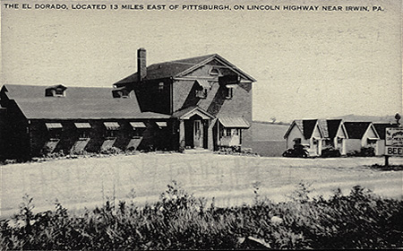
1934: Signs advertised spaghetti, steak, chicken, beer, and dancing to an orchestra.
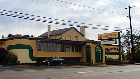
2007: You can still see the roadhouse and to its left, a one-story building with gable windows.
According to a Tribune-Review article, the 3.6 acre plan needed a variance or it would not have been allowed under the shopping center code, so 58 parking spaces will serve where 87 would otherwise be required for that size development. Also, the township asked for an electronic community bulletin board along the Lincoln Highway across from the intersection with Lincoln Way (a road deceptively named in the 1920s to divert LH traffic through the Mon Valley). An Eckerd Pharmacy already sits across the road at that intersection.
According to Walnut Capital’s site, the developer also bought and is demolishing the 1964 Colonial Revival headquarters of the Municipal Authority of Westmoreland County on the Lincoln Highway to the east in Hempfield (west of Greensburg) for a Walgreens and other retail. (That 16.1 acre site went for $6 million.) In a nod to the road, it will be known as Lincoln Place. Click here for images of that development.
Tags:Chesterfields, highway, history, Irwin, PA, restaurant, Road trip, roadhouse, Starbucks, travel, Walgreens
Posted in highways, history, roadside, travel | 1 Comment »


