Posts Tagged ‘transportation’

South Bend touts improvements to Lincoln Way

January 30, 2008

A press release from South Bend, Indiana, describes the city’s participation in Commercial Corridor Façade Improvement and Residential Enhancement matching grant programs, which aim to enhance neighborhoods and business districts through joint public and private investment. A portion of the Lincoln Highway there is benefitting from these efforts.

IN_SoBenCamStore

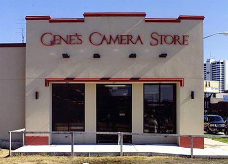
Gene’s Camera Store on Lincoln Way West is seen as a shining example of the commercial corridor improvements. From a press release:

Owned and operated by Mr. Jack St. Pierre since 1981, Gene’s Camera Store has recently undergone façade improvements with the help of a grant from the City’s Commercial Corridor Façade Improvement Matching Grant Program. Mr. St. Pierre made visual improvements to the west wall of his business and constructed a new parking lot in the vacant space next to the store. The parking lot, complete with lighting and landscaping, allows customers to park safely next to the store and enter through the new west door. The improvements were made possible by a City grant of $20,000, which Mr. St. Pierre matched with a private investment of $42,605.

The Lincoln Way West Steering Committee and its subcommittees (Land Use, Marketing and Safety) were formed in 1999 as part of Mayor Stephen J. Luecke’s Commercial Corridor Initiative; a Neighbors subcommittee was formed in 2003.

“In the last year, on Lincoln Way West alone, eight businesses were able to enhance the facades of their stores,” said Mayor Luecke. “Through the cooperation of local business leaders and the City of South Bend, over $140,000 was invested in this commercial corridor on which we stand. Helping these small businesses to revitalize the arteries of South Bend is imperative to the future success of our city.”

Sunset Motel cabins a challenge for Evanston, WY

December 18, 2007

One of the stops during the 2008 Lincoln Highway Association conference in Evanston, Wyoming, will be the remains of the Sunset Motel. The string of six rooms—three with built-in garages—are on Bear River Drive, the LH on the east end of town near WY-89. Built in 1932 in Mission or Spanish Colonial Revival style, this portion of the motel has been saved—the question now is what to do with it.

WY_Sunset1

I asked Jim Davis about the motor court. He’s Director of Administrative Services for Evanston and also on the Advisory Board for the Wyoming Main Street Program, on the Advisory Board for the National Trust for Historic Preservation, a staff member for the Evanston Historic Preservation Commission, and a founding member and past chair of Tracks Across Wyoming.

The good news about the Sunset Cabins is that they are still standing. Bad news, we still haven’t figured a new use for them and they remain threatened. The Evanston Preservation Commission had them listed as locally significant; however this does nothing to protect them as Evanston does not have a demolition ordinance or any such preservation ordinance. The cabins remain with the ownership of the city and we are still trying to figure a way for us to find adaptive reuse in order to secure their future. A little over a year ago we placed a restored Lincoln Highway marker at the site in order to draw attention as to the significance of this site.

WY_Sunset2

One of the problems with any restoration effort is how to adapt and reuse. Jane Law, City of Evanston Urban Renewal Coordinator (and who kindly arranged for these photos), says, “We have heard artist studios, concessions, but nothing that gets everyone stirred up enough to get something done…. It would truly be a shame to ever lose them, they are quite unique and really pretty cute. The state is restoring some motor cabins in Ft. Bridger, so maybe we can get some more interest there for them to come a little further west.”

Another issue is having the resources for every worthy project:

At present we really have our hands full restoring, rehabilitating, and preserving our wonderful and unique roundhouse and railyards site…. We are also trying to rehabilitate a historic hotel in our historic downtown; that has been a very long process with years of delay. Our Renewal Agency just purchased what remains of our downtown theater. That will be quite a project in itself. There was a terrible fire there in May and the building is just a shell now, but not wanting a hole in the block or a mini parking lot, we stepped up and will try to make that a viable business for our downtown. So we have our hands full, BUT the Sunset Cabins are something our Historic Preservation Commission should address. I do think those coming next year [to the LHA conference] will like them and could play a big part in thinking of a reuse. [my emphasis]

Jane also sent a detailed and fascinating hisstorical survey of the site that I’ll review soon in a separate post.

PA's Westmoreland County plots future of US 30

November 21, 2007

The two developments mentioned yesterday are just a small part of Route 30’s spiraling growth east of Pittsburgh. Concern for the corridor led the Smart Growth Partnership of Westmoreland County to host a 5-day design charrette atPA Growth logo the University of Pittsburgh’s Greensburg campus (its home base). The focus was the future of U.S. 30/the Lincoln Highway—how to specifically preserve the rural landscape, revitalize towns, and enjoy the benefits of growth while avoiding clogged roadways, vanishing open spaces, and soaring home prices.

A 4-year study started in 2005 covers 40 miles and 12 municipalities from Pittsburgh’s eastern suburbs to the Laurel Highlands, known to Lincoln Highway travelers for the steep winding road on the west side of Laurel Mountain. A master plan being developed will present a prototype for safe, efficient, attractive, and connecting land use. The finished plan is expected in April 2008, followed by a year of implementation. According to Smart Growth, the project is unique in that a non-profit entity is taking a proactive, collaborative approach to help shape communities.

PA_Greensburg rural

Above: The Lincoln Highway east of Greensburg, Pennsylvania. With 4-lane US 30 to the right, and houses rising on farmland to the left, how long can this rural roadscape survive?

An article in the Pittsburgh Post-Gazette summarized the concepts developed by the group with help from a team of design professionals, engineers, architects, urban planners and landscape architects:

• Mixed use development with the highest density centered on Route 30.

• Public open spaces providing gathering places throughout the site.

• A gateway at the intersection of Route 30 and Route 981 serving as an “arrival point” to Latrobe and the Laurel Highlands.

• Retaining the Route 30 corridor as a regional connection with parallel roads providing local “circulation.”

• Greenways defining the development areas as well as connecting the rural context of the development.

Visit www.route30plan.com to see the plan, photos, and more information.

Also from that stretch of US 30/Lincoln Highway, here’s a view of the nice-looking building mentioned in yesterday’s post – the headquarters of the Municipal Authority of Westmoreland County, courtesy of that group via Susan Schmucker, whose brother’s construction company (Dill Construction) built it in 1964. It’s faced in Delaware River sandstone and topped by a metal cupola that conceals the chimney. Cost, including fountain and parking lot, was $312,500 back then. The authority moved out the end of October and it’s set to be demolished. Susan says they outgrew the facility, and traffic had increased dramatically due to retail development, but they will miss it.

PA_MAWC