Archive for the ‘transportation’ Category

1915 article leads to LH routing mystery

March 7, 2008

Jim Steeley, of the Westmoreland County Historical Society and a LH researcher, came across a Lincoln Highway item in the September 30, 1915, Greensburg Daily Tribune, about rerouting the LH away from Madison, Pennsylvania. Problem is, the LH never went through Madison!

PA_HerminieArticle.jpg

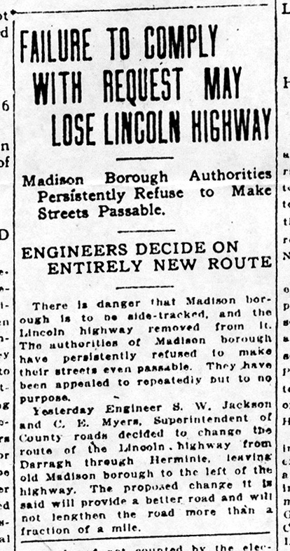
The article “Failure To Comply With Request May Lose Lincoln Highway” appeared on the front page of the paper describing Madison Borough’s refusal to improve its streets, therefore endangering the borough “to be side-tracked, and the Lincoln Highway removed from it.” It cited an engineer and a superintendent of county roads who “decided to change the route of the Lincoln Highway from Darragh through Herminie, leaving old Madison Borough to the left of the highway.” It would “not lengthen the road more than a fraction of a mile.”

PA_HerminieMap.jpg

But the Lincoln Highway is not known to have gone anywhere near Madison, let alone through it. To follow this route, Jim explains, the Lincoln Highway would have run through Greensburg to West Pittsburgh Street where it intersects with West Newton Street and hence to the West Newton Road (Rt 136) through Darragh, o to Madison (until it was bypassed) and Herminie, then north on Clay Pike through Rillton to Circleville at the top of Jacktown Hill, where it would join present-day US 30 west of Irwin. The map above shows the commonly known LH in red, the implied route in blue, and the topic of the article (routing through Madison) in green.

The first official LH road guide, published spring 1915, lists Greensburg followed (heading west) by Grapeville, Adamsburg, and Irwin—all along the red-marked route, similar to today’s US 30. Why, a half-year after the 1915 guide was published, was it believed that these towns were on the Lincoln Highway?

Small blast hits Times Square recruiting station

March 6, 2008

The New York Times is reporting that an “improvised explosive device” damaged an armed forces recruiting station at 3:43 a.m. in Times Square, the eastern terminus of the Lincoln Highway in New York City. No one was injured in what is being called a small blast. Most of the damage was to the front door and facade of the Armed Forces Career Center on a traffic island bounded by 43rd and 44th Streets, Seventh Avenue, and Broadway. Traffic through Times Square was reopened by 6:45 a.m. For the story with updates and comments, click the screen shot below from The New York Times:

NY_NYT_blast.jpg

More details on Nevada IA's Lincoln Highway Days

March 4, 2008

Lincoln Highway Days treasurer Linda Griffith reports that the theme of this year’s celebration in Nevada, Iowa, will be “25 years of Family Fun.” Along with the carnival and rodeo, there will be “Crafts and Arts and Flea Market,” food vendors, dances for teens and adults, Klassy Kruisers antique car club from Ames, and a display of antique tractors. The parade on Saturday will start along Lincolnway at 9:30 a.m. and the all-day big celebration will follow at the Story County 4-H grounds located lst Street and I. Avenue. Below are some images from http://www.lincolnhighwaydays.com from past events.

IA_LHD_12.jpg

IA_LHD_23.jpg

IA_LHD_70.jpg

Nevada, Iowa announces 2008 Lincoln Hwy Days

March 3, 2008

The interestingly named town of Nevada, Iowa, will celebrate its 25th annual Lincoln Highway Days this August 22, 23, and 24, 2008. Info for the coming year will soon be posted on www.lincolnhighwaydays.com. The event usually includes a carnival, dance, rodeo, and a big parade.

IA_LHD_sm.jpg

Nevada is east of Ames and just west of the popular Niland’s Cafe/Colo Motel. The original Lincoln Highway Day in October 1983 was actually called the Old 30 celebration to coincide with the completion of a railroad overpass west of Nevada.

Lincoln Highway News tops 10,000 hits

March 1, 2008

Yesterday, Lincoln Highway News topped 10,000 hits, all since mid-October. Thanks to everyone who has sent info and images. Enjoy the trip!

IN_72907_1549.jpg

Mystery photos 4 & 5: NE and WY

February 29, 2008

Daily snow the past few weeks has us dreaming of sunny drives along the Lincoln Highway, so here are a couple summertime photos from western Nebraska and western Wyoming. Can you correctly identify either location?

NE_46_sm.jpg

WY_0046_sm.jpg

To see them larger, click on each one for a connection to Flickr. Once there, click “All Sizes” above the each image to see them even larger.

"Historic LH" sign marks Summit Garage in CA

February 28, 2008

Folks in California just can’t stop marking, promoting, and preserving the Lincoln Highway. Gary Kinst, editor of LHA’s California chapter quarterly newsletter The Traveller, sent a couple photos from the recent dedication of a “Historic Lincoln Highway” sign at the Summit Garage in Altamont. From left are Deborah DuBois, Mike Kaelin. Al Vieux, and Linda Krhut.

CA_SumGar

Al, a cattle rancher in the area since 1951, owns the garage. In a few days, Deborah and Linda will be opening “Creative Cave” antique and stained glass shop there. (Linda had been involved with Tri-Valley Youth Services that occupied the building last year – see LH News entry for 2/15/08). Mike is the Alameda County rep./consul for LHA California, and an ad hoc advisor to the Summit Garage. And to make our story complete, Gary formerly owned 5 automotive garages in the East Bay area, and now writes and researches garages and the Lincoln Highway in addition to his day job.

CA_SumGar

Forbes Trail was precursor to much of Pa’s LH

February 27, 2008

A new web site commemorates the 250th anniversary of Forbes Trail, hacked through the forests of Pennsylvania in 1758 during the French and Indian War. General John Forbes led an expedition from Philadelphia over the Allegheny Mountains to capture French-occupied Fort Duquesne, at what later became Pittsburgh. Among the 6,000 British and colonial troops was young George Washington, a 26-year-old colonel with the Virginia troops. The www.forbestrail.org site is a project of French and Indian War 250, the organization spearheading the commemoration of the French and Indian War.

ForbesTrailMap

Forbes Trail (also commonly called Forbes Road) was closely followed or paralleled by the Lincoln Highway and US 30 across the state. Only mid-state does it deviate, when the military road jogs north to Carlisle, near Harrisburg. The Lincoln/30 stays south through Gettysburg and Chambersburg.

FIW_SigVert.jpg

The web site features seven “gateways” – Philadelphia, Lancaster, Carlisle, Fort Loudoun, Bedford, Ligonier, and Pittsburgh – where visitors can click to learn its connection to the trail and what historical remnants survive.

A long-anticipated book is due in May. Pennsylvania’s Forbes Trail: Gateways and Getaways along the Legendary Route from Philadelphia to Pittsburgh ($18.95) will feature more than 40 themed tours with info on activities, lodging, and dining.

PA_ForbesTrlBook

I asked French and Indian War 250 Marketing Director Karen Lightell about the difference between calling it Road and Trail. She said they “chose ‘Forbes Trail’ to avoid confusion because many people see the Forbes Road as extending only from Carlisle to Pittsburgh—i.e., the road the Forbes Expedition actually built. They traveled from Philadelphia on existing roadways. ‘Forbes Trail’ is meant to imply the entire experience ‘today’ of the corridor along the original Forbes route as described in the book.”

More Sleepy Hollow Tavern history recalled

February 26, 2008

The Pittsburgh Tribune Review ran another article today recounting some history of Sleepy Hollow Tavern. Former workers, owners, and customers offer a variety of fond recollections. As Julie Donovan, public relations director for the Laurel Highlands Visitors Bureau, said, “It seemed no matter who owned it, it was always busy. It was definitely a Laurel Highlands landmark, and I hate to see it go.”

SleepyHollow1930s.jpg

Above: A photo that was on the wall of Sleepy Hollow when I first visited in 1989 shows the 1930s sandwich stand and gas pumps.

Although a descendant of former owners says it was always Sleepy Hollow, my recollection from a 1989 visit is that that’s correct for the restaurant but not the land around it. The area was known as Kelley’s Hollow; co-owner Joe Neiman’s habit of dozing in his rocking chair in the 1930s led to jokes about Sleepy Hollow, which was used to name the tavern that opened in 1940.

PA_SlHol_Trib226.jpg

Click the screen shot above for the full Trib article.

Sleepy Hollow Tavern fire being investigated

February 25, 2008

Cy’s matchbook
Above: A vintage Sleepy Hollow matchbook, courtesy Cyrus Hosmer.

The weekend fire at the former Sleepy Hollow Tavern along the Lincoln Highway in western Pennsylvania has left the building charred and condemned. According to the Pittsburgh Tribune-Review, after burning overnight Saturday onto Sunday, firefighters were called back at 11:30 Sunday morning when the roof reignited. The second floor, which once housed a dozen hotel rooms, has fallen into the first floor restaurant. Click the image below for the full story from the Trib:

PA_TribSlpyHol.jpg

Youngstown Fire Chief Barry Banker, who led some 20 area fire crews, said when he arrived, smoke was coming out of the building from every direction. After attempting to enter the 1939 wood-frame structure, they turned back and could only fight it from outside. There were no injuries reported, but KDKA-TV reports that state police are saying the blaze is suspicious in nature.

Sleepy Hollow was a popular stop since being built 1939-1940, but suffered after the westbound lanes of Lincoln Highway/US 30 were moved across Loyalhanna Creek. A small causeway was added, and after some success as a buffet in the 1980s, the business has had various remodelings. The Trib reports that the most recent owners tried filing for bankruptcy in November.

WPXI-TV has a short story calling it a biker bar. KDKA now has their video report online – click the images below:

PA_KDKA_videoSLpyHol

The surrounding area remains visually stunning: in 2005, the county purchased 1,239 forested acres from the Western Pennsylvania Conservancy for $900,000 to create The Loyalhanna Gorge Greenway, stretching 3 miles along both sides of the Loyalhanna Creek from the Kingston Dam to Longbridge through Chestnut Ridge.