Posts Tagged ‘historic’

Marker for Wiggin's Trading Post in Lathrop – pt 2

January 10, 2008

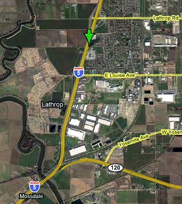
More than 50 officials, friends, and members of the Wiggin Family and Lincoln Highway Association braved chilly temperatures to dedicate a marker that honors both the Lincoln Highway and Wiggin’s Trading Post that opened there in 1924. The ceremony was held Saturday, December 8, 2007, at 15600 S. Harlan Road in Lathrop, California.

CA_Lathr_4109
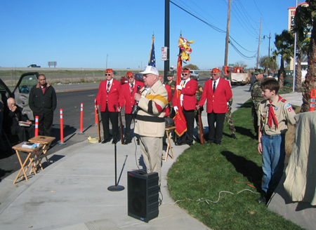
Above: At the Lathrop marker dedication, from left to right: Bob Dieterich, James Lin, Gary Kinst, Paul Gilger, Norm Root. Lloyd Johnson, Mike Kaelin, and Carolyn Lignos. The plaques read: (top) Lathrop Sunrise Rotary; (middle) America’s First Coast to Coast Road Established 1913; (bottom) 1924-1967 Site of Original Wiggin’s Trading Post Serving Travelers Along The Lincoln Highway.

Francis Wiggin’s Granddaughters, Janet and Patti, presented photos to master of ceremonies John Serpa (SEE BELOW), a member of LHA and the Lathrop Sunrise Rotary Club. Marine Corps League Detachment #109 from Modesto presented the colors, and Boy Scout Troup #425 from Lathrop led the singing of the National Anthem and the unveiling of the monument.

CA_Lathr_4107

A Marine Corps League Certificate of Appreciation for Loyalty and Patriotism was presented by John Treantos, Commandant of #109, to Mr. Dalwinder Dhoot for flying the American flag continuously 24 hours a day, 7 days a week for 14 years at Joe’s Travel Plaza. Dhoot and family own the new Best Western Hotel at the site, and graciously allowed the Rotary to erect the marker. Mr. Dhoot then invited all guests to join the grand opening festivities for the 3-floor, 81-room hotel and provided complimentary food and beverages.Speakers included:Kristy Sayles, Mayor of Lathrop.Norm Root, President, California Chapter of the LHA (SEE BELOW).

CA_Lathr_4108

Thanks also go to:Gabe Young, cement and engraving of stone monument.Brian Green, Signarama of Tracy.Stephen Dresser, President, Lathrop Sunrise Rotary.Dolores Delgado, Chief of Police, City of Lathrop.Charles Edwards, Boy Scout Troup #425 Leader.Richard Wiggins, Grandson of Francis Wiggins.Mary Kennedy, President, Lathrop Chamber of Commerce.And I again thank Gary Kinst for helping with info and images for this report.

Marker for Wiggin's Trading Post in Lathrop – pt 1

January 9, 2008

A marker was dedicated Saturday, December 8, along South Harlan Road at Thomsen Street in Lathrop, California, to commemorate the Lincoln Highway and a family business that once occupied the corner. Francis Wiggin opened Wiggin’s Trading Post along the Lincoln Highway south of Stockton in 1924. He carried Gilmore Gasoline, then in 1932, began selling “Indian Head” Gasoline, which he had patented. He also sold Indian souvenirs, learned from his days working with the Buffalo Bill Wild West Show.

CA_Wiggins

Francis Wiggin’s son Francis Porter Wiggin II and his wife Ruth had seven children: Frank, Paul (b. 1934), Richard (b. 1936), Tom (b. 1940), Janet (b. 1946), Don, and Patti (b. 1955). Above, Wiggin’s grandchildren Janet and Tom ride a play horse/burro in 1949. Near the pumps might be one of their brothers.

Son Francis II joined the business around 1936, and Francis Sr. passed away in 1950. The Trading Post closed in 1967, but grandson Richard operates (but has it for sale) Wiggin’s Trading Post in Chilcoot, California at 94139 Highway 70. Another Wiggin’s Trading Post is said to be in Arizona but the location and owner are not known.

CA_Lathrop Map

The Lincoln Highway went south from Stockton through Lathrop on what is now Harlan Road on its way to Tracy. I-5 now closely parallels the old road. Information about the ceremony will follow in a separate post. Thanks to Gary Kinst for helping with info and the image.

Hamilton, NV – A Lincoln Highway Ghost Town

November 5, 2007

Ghost towns fascinate most of us, and many books and web sites chart the rise and fall of these once-booming settlements. Rick Pisio (see previous post) captured some amazing views at Hamilton, NV, a mining town on the original Lincoln Highway east of Ely.
NV_Pisio_Hamilton

Silver was discovered here in 1868, and within two years, there were more than 13,000 mining claims. Main Street grew to a mile long and the town itself a mile-and-a-half wide, with two banks, two newspapers, post office, courthouse, school system, water and steam company, churches, fire companies, and a hotel considered the state’s most expensive structure. Hamilton even became the first seat of White Pine County. But the ore layer was thin, and folks left as quickly as they had come. An intentional fire in 1873 (for insurance money) destroyed much of the town.

Even though it’s a 10-mile drive from US 50 over bumpy dirt roads, many make the journey, though their visits, and natural weathering, take a noticable toll. Online images show the brick structures crumbling a bit more every year, and soon, little will remain standing.

Two historic views from Ghost Towns: How They Were Born, How They Lived, and How They Died by Tom Robotham (Running Press, 1993) show the Wells Fargo bank as the town’s most prominent structure:
Ghost Towns book

See more of Rick Pisio’s photos from this and other Western ghost towns at rwphotos.

A detailed history of Hamilton is available at White Pine County Nevada History and Genealogy Research site.

For USGS maps on getting there, check The Lincoln Highway: Nevada by Gregory Franzwa and Jess Petersen. The 1913 LH stretches over maps 39-43.