By 1921 it had the usual amenities found in any such western camp. In earlier years [Pioneer S]take leaders had noted the increasing thousands who spent time at the auto camp before passing along, and they realized they had an unusual service opportunity. That summer of 1921 they pitched a large tent at the camp and held church services, both on Sundays and during the week. Meetings were short and casual, and relied on music and the recitations of Sunday School children. The various ward choirs in the stake took turns providing music, and talented instrumental soloists offered their services. Stake officers provided brochures, sold copies of the Book of Mormon, and answered questions. Some 25,000 tourists were served in that first year alone.
In 1922, the project expanded, and stake members build a small chapel, open on one side to face rows of benches in the open air. And word began filtering back from missionaries in the field, that they had been welcomed into the homes of people who had stayed at Salt Lake’s auto camp and changed their opinion of the habits and character of the Mormons.
ABOVE: an image of the auto camp missionaries from the article, which identifies the men.
TOP IMAGE courtesy Russell Rein.
SLC and the 1860s Tabernacle were regular stops for most everyone motoring through Utah. As the author points out, and as seen in period travel journals, many wanted to see what Mormons looked like. Early auto traveler Harriet White Fisher was among those who stopped to see but concluded, “I could find no marks of identification that made them any different from other men in the East.”
The Deseret News had a nice feature on Gregory Franzwa, author of 20 books including a state-by-state series on the Lincoln Highway. His new book, The Mormon Trail Revisited, retraces the 1846-47 route of the Mormon pioneers across the midwest and into Utah. The book mixes history with driving directions to the 1,400 miles of trails and country roads. Its 284 pages include more than 200 photographs of the trail and historic sites.
The article offers some insights into the author’s work and the trail:
“This exodus was the most amazing thing. There’s been nothing like it before or since. You think of the 2,500 humans and 500 wagons that left Nauvoo and camped at Sugar Creek. That has to be the biggest wagon train in history times 10.”
Franzwa and his wife, Kathy, who now live in Tooele, spent three years tracking the trail. They follow the mass exodus across Iowa, where the “adhesive mud so frustrated the pioneers’ plans to cross the Rockies that year that they had to hole up along the Missouri River. That must have been so discouraging for them.”
He then follows the trail that Brigham Young and the lead wagon train followed across the plains and into the Salt Lake Valley. “We found every single campsite,” he says.
His purpose in writing the guide was twofold. He wants to help people get there — “right in the traces. Right where the mules and oxen and wagon wheels left those scars. To get out of the car and stand in those ruts….
A second reason for the guide, however, is equally important, he says — to encourage preservation. “When a person has read that history, stood right on those pioneer pathways and driven or hiked the pioneer routes, it is unlikely that there will be much support for proposals which would damage or destroy the historic trails or sites.
To purchase the book ($24.95 paper, $39.95 cloth) or for more info, check Franzwa’s Patrice Press site patricepress.com/.
PBS producer Rick Sebak has called the past few days reporting that like any good road trip, there’s just too many places to explore when you’re trying to keep to a schedule: “There’s so much to see, we could do this forever.”
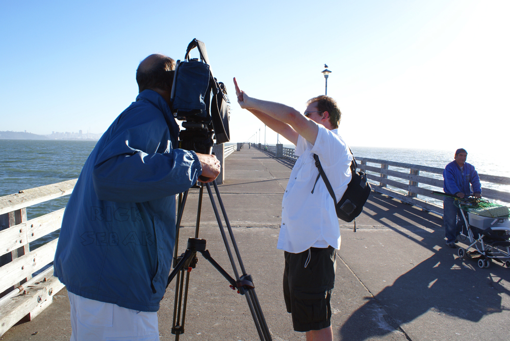
They’re on their second cross-country trip fiming for A Look Along the Lincoln Highway, premiering this October. Amazingly, this afternoon Rick and Bob and Glenn are driving east and will be pulling into the Lincoln Highway conference in Evanston, Wyoming. Amazing because they passed by just a few days ago heading west into Utah where they interviewed former LHA president Jess Peterson, headed down Johnson Pass (above, though Gatofeo wrote to say this is actually Dugway Pass), crossed the Great Salt Desert, got a flat tire, interviewed Jay Banta and toured with him, crossed Nevada, filmed in the Sierras and Placerville, reached the terminus, and are blazing back eastward. Amazing too are the photos and videos they’re capturing for their blog. Here are some extra beauties from Rick – CLICK on them for larger views. Makes you want to hit the road, doesn’t it?
• Horses along Pony Express Road, a LH bypass around Dugway, Utah.
• Pony Express Road meets the LH east of Fish Springs, Utah.
• Jay Banta shows the crew around Kearney Ranch, Callao, Utah.
• Crossing Nevada.
• Bob and Glenn set up a late-day shot at Berkeley Pier on the San Francisco Bay.
• Sebak reaches the Western Terminus in San Francisco for time #2.
Remember to CLICK on them for larger views – and you’ll soon be planning your own trip.
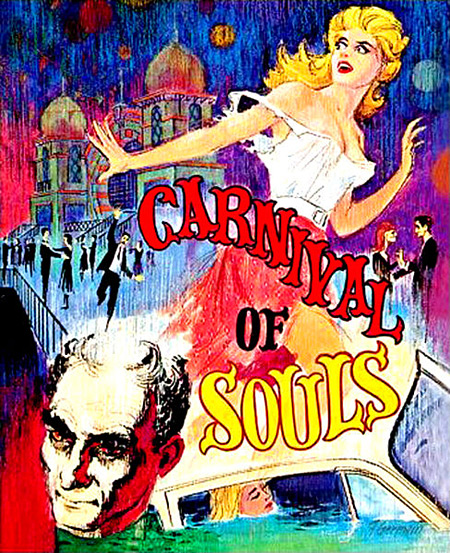
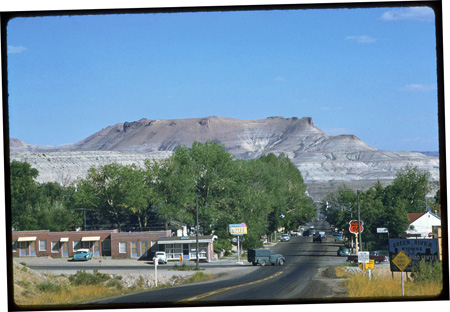
Carnival of Souls, a low-budget horror film directed by Herk Harvey in 1962, never achieved much fame or acclaim, yet it’s become a a cult favorite and is often mentioned as an influence by other filmmakers. It’s theme of a woman caught between life and death was unusual for its time and is cited as a reason that it rises above similar films. For Lincoln Highway fans, it offers a glimpse of Saltair, the famed lakeside bathing resort west of Salt Lake City, opened 1893 and connected to the city by rail. It later became a regular stop for cross-country travelers.
Above: The Moorish domes of Saltair are represented in the Carnival of Souls movie poster.
The lead character, Mary, is in a car wreck and assumed drowned. Instead, she apparently lives, becoming a church organist, but is haunted by a ghostly man. Her journey culminates in a trip to an ominous pavilion, which takes place at Saltair.
The creepiness in Carnival of Souls comes mostly from the dreamlike atmosphere instead of cheap scares or special effects. The pavilion keeps drawing her until she visits it in the climax. This clip, part 11 of 11 on YouTube, features great views of Saltair before it burned again in 1970. The first minute is spent with Mary reflecting, but then she is spooked, screams, and finding herself in her 1960 Chevy, backs out of a garage. At 1:56 we see her driving the approach road to Saltair and seconds later walking through it. About 3:30 ghouls arise from the lake to dance (or at least that’s my amateur interpretation of the action). About 5:50 they begin chasing her – she tried hiding among the support poles underneath. Views of the exterior start at 6:53 and a minute later it returns to the scene of the crash that started the movie and we learn her fate. WARNING: The scares are tame and the pace slow by today’s standards but nonetheless might be unsettling to some.
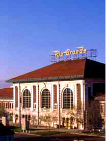
I’ve added more sites to the Lincoln Highway Libraries & Museums page; see the link to the right. There are many local and state libraries and museums along the route, such as the Utah Historical Society (click their photo to go to the web site). Since 1980, it has been located in Salt Lake City’s former Rio Grande railroad depot. (The LHA held a reception there during its 1998 conference.) The elaborate station was completed in 1910 at a cost of $750,000 and sold to the city in 1977 for $1, which says a lot about how transportation changed in the intervening 6 decades. The restored depot is 3 blocks south of South Temple St and 4-1/2 blocks west of Main St.
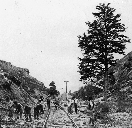
The Lincoln Highway often followed the course of the Transcontinental Railroad out west, mostly in spirit but sometimes atop it. When the railroad was built through Weber Canyon in eastern Utah in 1868-69, workers planted a “1,000 mile tree” to mark the point 1,000 miles west of their starting point of Omaha, Nebraska. I see references occasionally to the tree, and have noticed a couple stereoview cards online. A few photos were taken too, such as this one as the rails are laid in 1869 from the U.S. Geological Survey Photographic Library:
Check out the sign hanging from it!
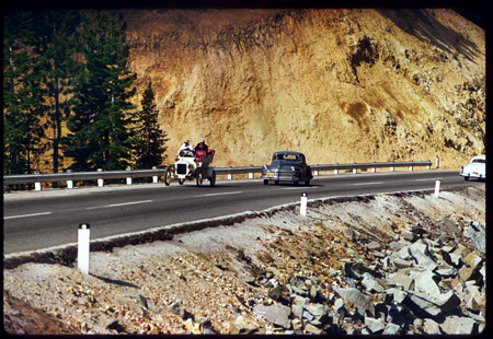
The Lincoln Highway cut through the canyon some 45 years later, as did I-84 probably 60 years after that. I don’t remember seeing the tree or signs for it, but it is said to still be in Wilhelmina Pass, a mile east of Devils’ Slide. Click on the thumbnail below for a recent view from I-80 (and once there, click the magnifying glass to see the phhoto much larger):
That looks to be the pine tree on the right, next to the white square, which is probably a sign. Surely the tree has been written about by Utah historians or by railroad fans. Can anyone tell us more about it?
The Rio Grande Railroad produced this black and white documentary in 1948 to promote the state’s wonders, and of course, encourage train travel. The film is a half-hour long but split into three parts. It only sometimes visits LH locations but is nonetheless an entertaining and nostalgic look at the state, tourism, and travel by steam engine almost 60 years ago.
1: Intro, Arches National Monument, horseback ride and spectacular rocks, Wasatch Mountains, Soldier Summit, Provo and Escalante Trail marker, Utah Lake, sugar beets, cherry blossoms. 10:18 min.
2: Copperton, Bingham (with horse-delivered mail), Utah Copper Company, worlds largest open cut mine, copper to electricity climax. 9:03 min.
3: Black Rock on Salt Lake, Saltair Pavilion and its Putt Putt railway, salt beds, highways to Ogden, cattle, sheep, train to SLC, D&RGW [Denver & Rio Grande Western]-WP station, streets, capitol, statues, Emigration Canyon monument, tabernacle, temple, cactus beehive (!), organ recital, ride home. 10:23 min.
The Charles Weever Cushman Collection at Indiana University, Bloomington, Indiana, consists of ten cubic feet of materials, including 2,200 b/w negatives and prints. Just three of those cubic feet are slides, but what a collection — more than 14,400 color Kodachrome slides shot from 1938 to 1969. Cushman’s photos have been digitized through Indiana University’s Digital Library Program and the Indiana University Archives and are now online.
An amateur photographer, most of Cushman’s images are scenic, many are from such countries as from Lebanon, Germany, Austria, England, and Mexico. There are few roadside or industrial sites, but roads and cars do make it into many of the slides. Here are some from along the Lincoln Highway or close to it—click the links to see larger views.
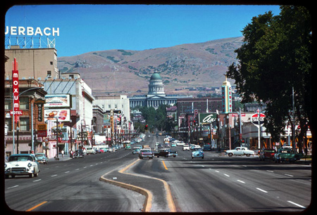
A clear day in Salt Lake City, 1958, looking north on State Street toward the capitol.
There’s lots else to see plus essays about Cushman and his collection. Photos reprinted here with the kind permission of Indiana University, Office of University Archives & Records Management, with special thanks to Curator Bradley D. Cook.
Like the Mystery Photos we sometimes run on weekends, there are likewise lots of postcards that we wonder “whatever happened to that place?” This beautiful linen card from the Curt Teich Company pictures the Country Club Motor Lodge and Coffee Shop, 2665 Parley’s Way, Salt Lake City, Utah. It advertised 55 “strictly modern units” and “Sun Porch and Modern Coffee Shop for Convenience of Guests.” It’s named for The Country Club across the road, one of the West’s oldest courses (founded 1899) and still an elegant, private 18-hole course. Today, housing separates the two just west of the tangle of ramps where I-80, I-215, and UT 186 meet.
This card, postmarked Aug 4, 1949, was sent by a child:
“We got here right today We will be back to Sacramento California soon We are haveing a nice trip so good-by and I will see you soon from Mary Jean”
What’s left at the site today? The phone number is now a private residence. A Yahoo aerial view shows it still there, but you can buy for a condo at the Country Club Ridge subdivision at the same address. Price for #310 is $649,000 for 2,065 sq ft, built 2007. Are we a year too late…?
The American Road Forum is a great place to ask questions and get info from roadside experts, including, of course, for the Lincoln Highway. You can browse as a guest, but sign up so you can add your own questions and answers.
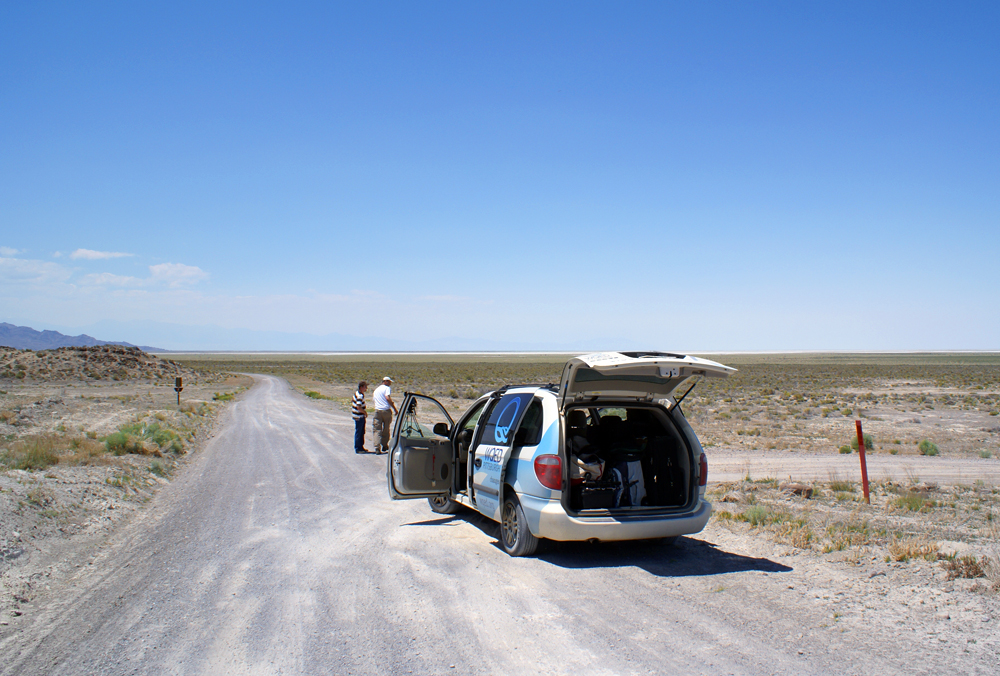
In May, Rick Pisio (whose website of impressive photos can be found in my Helpful Links section) asked about driving the LH west from the Pacific, especially the original alignment around the Great Salt Lake Desert. He got some wonderful insights and detailed replies: http://americanroadmagazine.com/forum/index.php?showtopic=383
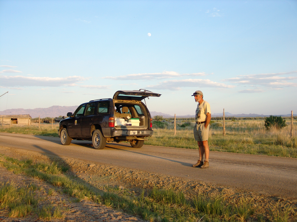
Rick made the trip in late July with his father Matt (who turns 70 this month – happy birthday!) and 14-year-old son Richard, whom he says really enjoyed it: “I talked enough about the history of the roads we traveled and he listened in on the conversations my dad and I had during the trip enough to understand that what we were doing was not your normal vacation. I think he also realizes that opportunities for 3 generations to travel on a trip like we did do not happen that often.” Must have worked – Rick says they hope to take another trip next year.
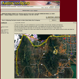
Rick’s posts to the American Road Forum picked up his journey three days into the trip, starting at West Valley City, Utah, traveling through Skull Valley to the US Army Dugway Proving Ground: http://americanroadmagazine.com/forum/index.php?showtopic=522 Here’s a view from the start of the trip looking south on the original LH in Skull Valley:
Here’s a view looking east to the Goodyear Cutoff, a contentious shortcut that’s been off-limits for more than a half-century. The sign’s faded lettering reads “Dead End Road, No Trespassing, Government Property.” The short post on the right has the Lincoln Highway logo and “Lincoln Highway” down its length:
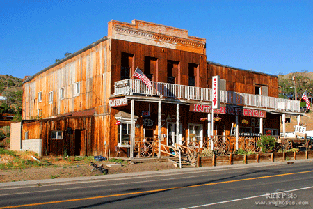
Days later, he captured sunset at the International Cafe in Austin, where they had the last dinner of their trip:
Anyone wanting to make the trip themselves will enjoy Rick’s storytelling and evocative images, plus maps of each day’s journey. All his posted photos, plus some not in the American Road reports, can be found at http://www.rwphotos.com/Scenics/scenicmain.htm
Click the map above for a full-size view of the Lincoln Highway.
Like this blog? You'll LOVE my books!Lincoln Highway Companion features detailed maps and places to eat and stay. Click the book to buy it on Amazon.
Click the Greetings book below to purchase the ultimate guide to the history and route of the Lincoln Highway!
Another fun book! The Ship Hotel: A Grand View along the Lincoln Highway recalls the greatest roadside attraction along the coast-to-coast road.
And for those who LOVE diners, click the book below to purchase our completely updated guide to the history, geography, and food of Pennsylvania's Diners!


 happy birthday!) and 14-year-old son Richard, whom he says really enjoyed it: “I talked enough about the history of the roads we traveled and he listened in on the conversations my dad and I had during the trip enough to understand that what we were doing was not your normal vacation. I think he also realizes that opportunities for 3 generations to travel on a trip like we did do not happen that often.” Must have worked – Rick says they hope to take another trip next year.