Archive for the ‘highways’ Category

"Historic LH" sign marks Summit Garage in CA

February 28, 2008

Folks in California just can’t stop marking, promoting, and preserving the Lincoln Highway. Gary Kinst, editor of LHA’s California chapter quarterly newsletter The Traveller, sent a couple photos from the recent dedication of a “Historic Lincoln Highway” sign at the Summit Garage in Altamont. From left are Deborah DuBois, Mike Kaelin. Al Vieux, and Linda Krhut.

CA_SumGar

Al, a cattle rancher in the area since 1951, owns the garage. In a few days, Deborah and Linda will be opening “Creative Cave” antique and stained glass shop there. (Linda had been involved with Tri-Valley Youth Services that occupied the building last year – see LH News entry for 2/15/08). Mike is the Alameda County rep./consul for LHA California, and an ad hoc advisor to the Summit Garage. And to make our story complete, Gary formerly owned 5 automotive garages in the East Bay area, and now writes and researches garages and the Lincoln Highway in addition to his day job.

CA_SumGar

Forbes Trail was precursor to much of Pa’s LH

February 27, 2008

A new web site commemorates the 250th anniversary of Forbes Trail, hacked through the forests of Pennsylvania in 1758 during the French and Indian War. General John Forbes led an expedition from Philadelphia over the Allegheny Mountains to capture French-occupied Fort Duquesne, at what later became Pittsburgh. Among the 6,000 British and colonial troops was young George Washington, a 26-year-old colonel with the Virginia troops. The www.forbestrail.org site is a project of French and Indian War 250, the organization spearheading the commemoration of the French and Indian War.

ForbesTrailMap

Forbes Trail (also commonly called Forbes Road) was closely followed or paralleled by the Lincoln Highway and US 30 across the state. Only mid-state does it deviate, when the military road jogs north to Carlisle, near Harrisburg. The Lincoln/30 stays south through Gettysburg and Chambersburg.

FIW_SigVert.jpg

The web site features seven “gateways” – Philadelphia, Lancaster, Carlisle, Fort Loudoun, Bedford, Ligonier, and Pittsburgh – where visitors can click to learn its connection to the trail and what historical remnants survive.

A long-anticipated book is due in May. Pennsylvania’s Forbes Trail: Gateways and Getaways along the Legendary Route from Philadelphia to Pittsburgh ($18.95) will feature more than 40 themed tours with info on activities, lodging, and dining.

PA_ForbesTrlBook

I asked French and Indian War 250 Marketing Director Karen Lightell about the difference between calling it Road and Trail. She said they “chose ‘Forbes Trail’ to avoid confusion because many people see the Forbes Road as extending only from Carlisle to Pittsburgh—i.e., the road the Forbes Expedition actually built. They traveled from Philadelphia on existing roadways. ‘Forbes Trail’ is meant to imply the entire experience ‘today’ of the corridor along the original Forbes route as described in the book.”

More Sleepy Hollow Tavern history recalled

February 26, 2008

The Pittsburgh Tribune Review ran another article today recounting some history of Sleepy Hollow Tavern. Former workers, owners, and customers offer a variety of fond recollections. As Julie Donovan, public relations director for the Laurel Highlands Visitors Bureau, said, “It seemed no matter who owned it, it was always busy. It was definitely a Laurel Highlands landmark, and I hate to see it go.”

SleepyHollow1930s.jpg

Above: A photo that was on the wall of Sleepy Hollow when I first visited in 1989 shows the 1930s sandwich stand and gas pumps.

Although a descendant of former owners says it was always Sleepy Hollow, my recollection from a 1989 visit is that that’s correct for the restaurant but not the land around it. The area was known as Kelley’s Hollow; co-owner Joe Neiman’s habit of dozing in his rocking chair in the 1930s led to jokes about Sleepy Hollow, which was used to name the tavern that opened in 1940.

PA_SlHol_Trib226.jpg

Click the screen shot above for the full Trib article.

Sleepy Hollow Tavern fire being investigated

February 25, 2008

Cy’s matchbook
Above: A vintage Sleepy Hollow matchbook, courtesy Cyrus Hosmer.

The weekend fire at the former Sleepy Hollow Tavern along the Lincoln Highway in western Pennsylvania has left the building charred and condemned. According to the Pittsburgh Tribune-Review, after burning overnight Saturday onto Sunday, firefighters were called back at 11:30 Sunday morning when the roof reignited. The second floor, which once housed a dozen hotel rooms, has fallen into the first floor restaurant. Click the image below for the full story from the Trib:

PA_TribSlpyHol.jpg

Youngstown Fire Chief Barry Banker, who led some 20 area fire crews, said when he arrived, smoke was coming out of the building from every direction. After attempting to enter the 1939 wood-frame structure, they turned back and could only fight it from outside. There were no injuries reported, but KDKA-TV reports that state police are saying the blaze is suspicious in nature.

Sleepy Hollow was a popular stop since being built 1939-1940, but suffered after the westbound lanes of Lincoln Highway/US 30 were moved across Loyalhanna Creek. A small causeway was added, and after some success as a buffet in the 1980s, the business has had various remodelings. The Trib reports that the most recent owners tried filing for bankruptcy in November.

WPXI-TV has a short story calling it a biker bar. KDKA now has their video report online – click the images below:

PA_KDKA_videoSLpyHol

The surrounding area remains visually stunning: in 2005, the county purchased 1,239 forested acres from the Western Pennsylvania Conservancy for $900,000 to create The Loyalhanna Gorge Greenway, stretching 3 miles along both sides of the Loyalhanna Creek from the Kingston Dam to Longbridge through Chestnut Ridge.

LHA's spring 2008 state meetings set

February 23, 2008

Here are some upcoming Lincoln Highway Association chapter meetings.

LHA banner

Iowa will hold a membership meeting on Saturday, April 12, 2008, in Denison, Crawford, County.

California’s spring meeting also will be held April 12, in East Castro Valley/Hayward.

The Ohio Lincoln Highway League will hold 14th annual state meeting on Saturday, April 26, at the Elks Club in Galion. It will be hosted by the LHA Mid-Ohio Chapter. Tours of local attractions will follow.

LHA’s Indiana chapter will host a lunch meeting, to be joined by Illinois, May 10 in Schererville that will include a ceremony honoring Art Schweitzer, leading expert on the Ideal Section.

Follow the links for more information.

A poem lamenting change along the road, in life

February 21, 2008

On OpEdNews.com, an entry by Vi Ransel will sound familiar themes to many Lincoln Highway News readers.

IL_barn_62505_0003
Above: Another farm sprouts housing along the Lincoln Highway, west of Chicago, June 2005.

In Memoriam

The place I grew up in the 50s is gone now.
Oh, the land is still there,
but the quilt-like farm fields blanketing the rolling hills,
the deciduous forests and the meandering streams
have been overtaken and replaced by an invidious, invasive species
of four-lane byways with a broad, medial stalk of conquering concrete
sprouting small, almost identical malls like profligate weeds dispersing seeds
every mile or so along the length of the Lincoln Highway.

One last dairy farm remains, attached to the Route 30 vine.
Contained by concrete, cows graze in green pastures
as fossil fuel-burners blindly whiz by emitting a life-exhausting fog.
The farm, a delicate anachronism, is out of place in its own place,
a symbol of a sustainable way of life set like a jewel
on the artificial energy-sustained existence
clinging tenuously to the grid by an electrical thread
generated by the last drops of once living,
long dead bodies of the plant and animal ancestors
of those same dairy cows.

Vi’s works appear widely both in print and online. She conducts Poetry Workshops and gives readings in Central New York. Her latest chapbook is “Sine Qua Non Antiques (an Arcanum of History, Geography and Treachery).

http://www.opednews.com/maxwrite/diarypage.php?did=6021

RoadDog lends personal touch to NIU story

February 21, 2008

NIU_Black_Ribbon Our good friend RoadDog regularly writes about the fun side of old road travel, but he’s also been following the story of tragic shootings at Northern Illinois University, which lies along the Lincoln Highway on the west side of DeKalb. He and his wife Liz graduated from there in 1973 and like so many, find it hard to reconcile a place you love with someone’s senseless act. They took time yesterday to revisit the campus and favorite places in town. Here are some excerpts from their experiences:

Flags from Sycamore to Dekalb were at half mast and many of the signs at local establishments had words of comfort regarding the tragedy. Same with flags and signs along Lincoln Highway, Il. Route 38.

We saw at least six news vans parked along the spaces closest to Cole Hall. This is now five days after the event.

We went outside again to the two tents set up to cover the boards on which people were writing their feelings. There are now four. It was nice that someone had supplied Sharpies of different colors to express the grief. Most just said something about prayers. However, some were quite poignant. A lot said, “We are all Huskies today,” some of which were from people from other schools.

Came home and Liz found that the NIU site on Legacy now has 371 pages with about ten entries on each page.

This Still Hasn’t Completely Registered.

To read all three of RoadDog’s heartfelt entries, click here: 1, 2, 3.

Click here to read bios of the five fallen students and a schedule of memorial services.

Lincoln Memorial: monument was almost a road

February 20, 2008

A detailed and engrossing story in The Washington Post recalls the tumultuous genesis of the Lincoln Memorial, including how the monument that we know was instead almost a road named for the President. It was referred to then as the Lincoln highway, the Lincoln Memorial Highway, or simply Lincoln Way – all years before the Lincoln Highway of this blog was proposed or its association incorporated in 1913. The article is titled, “The Lincoln Conspirator: Illinois Congressman Joe Cannon was determined to stop the Lincoln Memorial from rising on the Mall. He almost succeeded.”

LOC_Lincoln Memorial

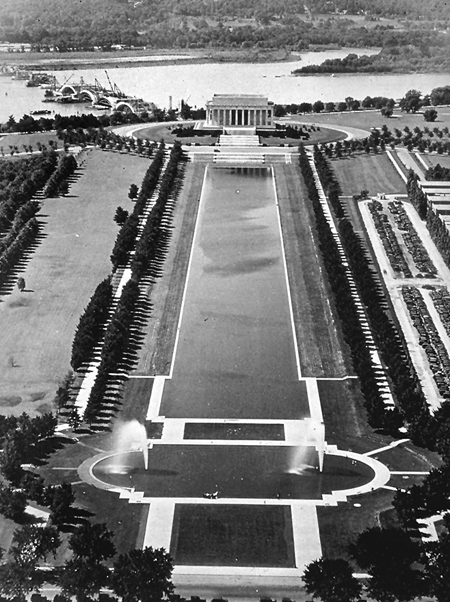
Above: An aerial view of the Lincoln Memorial, with Memorial Bridge under construction, c. 1930, courtesy LOC, Images of America: Lantern Slide Collection, from the Harvard University Graduate School of Design, Frances Loeb Library, Cambridge Mass.

A national monument to honor Lincoln in Washington, D.C., was proposed soon after his assassination, but the idea foundered until 1901 when the Senate Park Commission proposed the current monument as part of a plan to remake the Mall.

Here are excerpts that mention the idea of a highway:

What had most impressed [former congressman James] McCleary during his tour of Europe was the Appian Way, the ancient road in southern Italy built by Roman censor Appius Claudius. “Who has not heard of the Appian Way?” he wrote in the article. “What a fitting memorial to Lincoln would be a noble highway, a splendid boulevard, from the White House to Gettysburg.”

“The Lincoln Way” would include one roadway for automobiles and one for horse-drawn carriages and wagons; plus two electric railway tracks: one for express trains, the other for local trains. Stately rows of trees would border the highway. Down the middle would be a well-kept lawn 40 to 50 feet wide, with beautiful fountains and monuments at intervals along the way. Given “the possibilities of electrical illumination, the beauty of this boulevard when lit up at night may be left to the imagination,” McCleary wrote….

Rep. William Borland, the Missouri congressman who led the highway effort, predicted an easy win for the road. He believed cars would become more popular, though he didn’t drive one himself. Many congressmen found the prospect of obtaining federal dollars for road projects in their own districts tempting. Road supporters, backed by the auto industry, were well-organized. They flooded Congress with telegrams and petitions. Architect Glenn Brown’s campaign in favor of a Greek temple was no match. Everyone knew that a House victory for the Lincoln highway would create a stalemate and indefinitely postpone the creation of any memorial because the Senate wouldn’t agree to the road….

Highway advocates attacked the memorial plan as foreign and not representative of Lincoln, according to the Congressional Record. “There is nothing in this Greek temple . . . that even suggests . . . the character . . . of Abraham Lincoln,” said Rep. Isaac Sherwood of Ohio….

A highway is “nearer to expressing the epoch of American history than any other form of memorial,” said Borland, who emphasized that a road was unanimously endorsed by the Grand Army of the Republic, whose members were Union veterans. The Greek temple is the most hackneyed form of architecture known, he added…

Knowing that aesthetic arguments weren’t likely to sway members, [architect] Brown had prepared a cost estimate for the Lincoln highway, which Rep. Lynden Evans of Illinois used effectively during the debate. “It will cost at least $20 million to build a really distinctive road,” he said, and pointed out that it could be used only by those who could afford a car. “If a trolley line was placed upon it so that the plain people could use it, it would be valuable and useful . . . But it would not be a memorial of Abraham Lincoln.”

There were accusations at the time that road advocates tended to be those who would benefit from that project. Accordingly, one commenter to the article has written, “The ‘Road to Gettysburg’ sounded like the ‘Road to Nowhere’ considering Gettysburg was not a commercial center like, say Philadelphia or NYC. The practical value of a highway can’t have been a totally futuristic concept.” Of course, the Lincoln Highway proposed by Fisher would encounter some of the same arguments as the original Lincoln Way. Washington D.C. leaders would even advocate for Fisher’s coast-to-coast road to bend their way. Only after repeated pleas would the city get an official feeder – from Philadelphia through D.C. to Gettysburg, just as they had sought earlier.

"Faces of Lincoln" at Studebaker Museum till 3/9

February 20, 2008

This month begins a three-year bicentennial celebration of President Lincoln’s birth, with many books and exhibits marking the occasion. In South Bend, Indiana, the Studebaker National Museum (201 S. Chapin Street), in cooperation with the Indiana Historical Society, is featuring The Faces of Lincoln through March 9. The exhibit is comprised of holdings from the Jack Smith and Daniel R. Weinberg Lincoln collections, along with Studebaker National Museum’s President Lincoln Carriage.

IHS_LincolnPortrait

The first section of the exhibit looks at the history of photography using some of the best and most well-known images of Lincoln. Part two investigates ways that photographers, printmakers, and cartoonists tried to influence opinion about Lincoln by altering his appearance. Section three challenges viewers to determine what kind of images and symbols the printmakers used to convey their, and the nation’s, feelings toward Lincoln. The Faces of Lincoln exhibit is based on the Indiana Historical Society’s extensive collection and initially traveled the state on the Indiana History Train in October 2004 and 2005.

Classic cafe being razed in Grand Island, Nebr.

February 19, 2008

The Grand Island Independent reports that the Nebraska city is widening it’s main street – aka Lincoln Highway/US 30 – and in the process demolishing a vintage cafe. The Conoco motel and cafe at 2109 W. Second Street trace their roots to about 1940 when the tile-roofed Conoco Service Station opened. The cafe had a Polynesian redo in the 1960s but only the motel will survive (featuring a swimming pool and cable) as will a new convenience store. The cafe is seen in the upper right photo of the postcard below, which on back is titled, “Conoco Motel, Cafe & Service Station.”

NE_Conoco_GrdIsld

According to the news report:

A total of 18,400 vehicles travel daily on Second Street between Broadwell and Greenwich Street. To better accommodate that volume, the state will install a fifth lane a turning lane from Grant Street to Greenwich….

The right-of-way needed for the fifth lane simply brought the roadway too close to the Conoco Cafe, which the state acquired more than a year ago through condemnation. The last restaurant to operate there, Pam’s Cafe, closed Jan. 31, 2007, and relocated to South Locust Street.

Last week, an environmental firm removed asbestos from the cafe. This week, a construction company is starting demolition. Road work will commence March 17 and wrap up in October, then next Spring, sidewalks, lighting, and landscaping will be completed.