Can you name the location of this barn along the Lincoln Highway/US 30? Most fans photograph a sign a few miles east but speed past this interesting landmark. Looks like a store or two were adjacent. Need more clues?
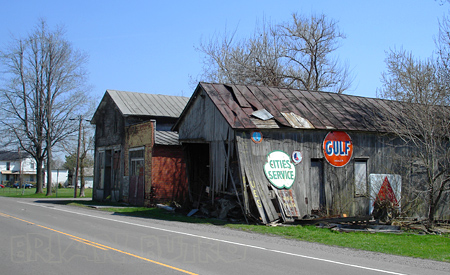
Can you name the location of this barn along the Lincoln Highway/US 30? Most fans photograph a sign a few miles east but speed past this interesting landmark. Looks like a store or two were adjacent. Need more clues?
The Pittsburgh Post-Gazette reports that the Lincoln Highway Heritage Corridor has been awarded $49,340 to build giant roadside attractions along its 200 miles of the Lincoln Highway. The projects will be designed and built by vocational/technical school students in themes that honor the 250th anniversary of Pittsburgh and its region. This and another article in Pop City calls them “roadside giants,” and in fact, the LHHC’s Kristin Poerschke tells me they hope to give each of the vo-tech schools a copy of my and Sarah’s Roadside Giants and Roadside Attractions books as part of the grant to help them with their designs.

The LHHC is one of 100 regional and grassroots organizations and artists who received a total of $1 million in grants to help celebrate the anniversary. LHHC director Olga Herbert says they are honored because only 12 were selected from the 230 regional applications.
LHHC will collaborate with four career and technical schools in Greensburg/Hempfield, Latrobe/Ligonier, Somerset, and Bedford/Everest as well as with four communities along the Lincoln Highway, giving studens a chance to be creative and contribute something permanent to the communities:
The project envisions the sculptures to include items like vintage motor vehicles, historical figures like George Washington, images from popular culture like Texaco gas attendants and diner waitresses, old fashioned bicycles and gasoline pumps. The project will call upon graphic arts students to design the super sized metal sculptures. Other students will weld the metal, and design and printmaking students will be in charge of the brochures. Not to be left idle, the culinary arts students will bake gigantic models of the sculptures.
 The LHHC, one of 12 such heritage areas in the state, promotes economic development through tourism along the historic route of the Lincoln Highway in Westmoreland, Somerset, Bedford, Fulton, Franklin and Adams counties.
The [Newark] Star-Ledger photographed construction of the new Prudential Center in Newark, New Jersey, over a period of three years and has posted a time-lapse online. The arena, opened in November, is steps away from the intersection of Broad and Market, a famed crossroads and traditionally one of the most congested intersections along the Lincoln Highway. The view is looking south, with Broad (the Lincoln Highway) to the right. The video is by Bumper DeJesus: click the image to open the Star Ledger page, where you can then click to start the video..
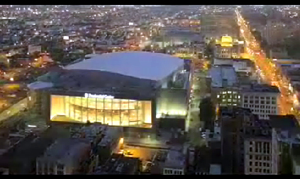
The Prudential Center hosts the NHL’s New Jersey Devils, Seton Hall Men’s Basketball, New Jersey Ironmen indoor soccer team, concerts, and special events. It is bounded by Edison Place to the north, Lafayette Street to the south, Mulberry Street to the east and Broad Street and City Hall to the west. Total cost was $375 million for a capacity of approximately 18,000 depending on the event. Outside, a 4,800 sq. ft. LED television faces Newark’s Penn Station. It was built where the large parking lot is seen on the Google map below. The Lincoln follows the yellow trace along Broad and Market streets.

As reported here previously, Idlewild Park along the Lincoln Highway in Ligonier, Pennsylvaia, will be sold as part of Kennywood Entertainment to Parques Reunidos of Spain, the third-largest European operator of amusement parks. The company only entered the U.S. market two months ago by purchasing 33 water parks. A British private equity firm acquired the company in January 2007 for $1.22 billion—such corporate entanglements worry fans of Idlewild and the other old-fashioned parks currently owned by parent park and company Kennywood.
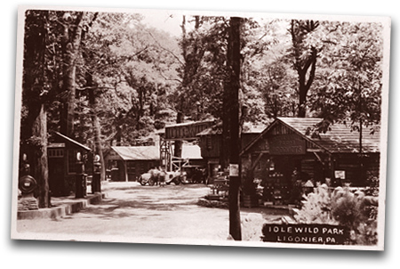
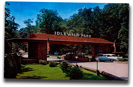
Here are some vintage postcards showing how Idlewild’s entrance changed over time (the first is from Cy Hosmer). The same round building can be seen in the first two views. This area still serves as an exit but the entrance was moved to the east years ago so that waiting cars would not back up onto the LH/US 30.

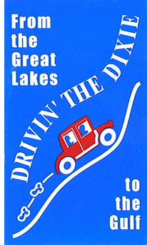 In our review of Traveling the … Historic Three by John and Lenore Weiss (which follows the Lincoln and Dixie Highways and Route 66), I mentioned Elaine E. Egdorf. Not only does she manage the Drivin’ the Dixie website, but as chairman of the Village of Homewood Heritage Committee, she got a Dixie Highway marker for Homewood, south of Chicago. The committee and the Homewood Historical Society (she was founding president) paid for the marker, which was dedicated in 2003 with a large ceremony. It was re-dedicated in 2005 as part of the kick-off for Illinois State Historical Society Markers week. The Dixie Highway communities also were recognized with a Superior Achievement Award from the ISHS for the unique way they pulled together towns, historical societies, and chambers of commerce to promote Illinois history.
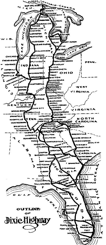
The Dixie Highway was another idea of Lincoln Highway founder Carl Fisher. His north-south path was said to have been created so his wealthy auto-industry pals could more easily travel south to Fisher’s Miami Beach land developments. The Dixie was not as direct as the Lincoln, but rather a braid of roads from Sou. Ste. Marie, Michigan, to Miami, Florida. The route is now identified throughout Illinois (except Chicago) with red, white, and blue metal street signs, street pole banners, and state markers. One of at least six intersections of the Lincoln and Dixie Highways is at Chicago Heights: the roads run together for almost two miles there and their meeting is commemorated by the Arche Memorial Fountain.

Above: Redd Griffin, Oak Park; Elaine Egdorf, Homewood; Arthur Martin, Chicago, at the rededication in 2005. All are on the Board of Directors of the Illinois State Historical Society.

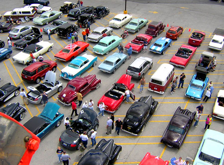
This group’s Triangle Tour has actually evolved into Drivin’ the Dixie, a moving car show and tour from Blue Island to Momence. A passport listing events in towns along the route can be stamped at historic sites; each town donates two prizes, and for each stamp, participants get a free raffle ticket. Last year about 200 cars total participated, mostly vintage cars. It’s nice to see such support for a road that played such a big role in early auto history.
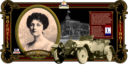
The Illinois Lincoln Highway Coalition (ILHC) recently received $443,000 in federal grants for its National Scenic Byway program, a designation the Lincoln Highway through Illinois received in 2000. The funds will be used over the next 3 years to produce interpretive murals in 40 communities along the 179-mile route through the state. Each mural will interpret the history and heritage of the highway and its impact on the communities, and a companion brochure will summarize their locations and messages.
Diane Rossiter, Associate Director of ILHC, says, “We are excited to begin this new project! This money, plus the $40,000 we just received from the state and the Illinois Bureau of Tourism will make it all happen. Our hope is that visitors will be compelled to travel Illinois Lincoln Highway and discover all that it has to offer.”

Three murals are already complete: Creston was unveiled in May 2006, DeKalb in October ’06, and Rochelle in May ’07 (see photo and closeup above, courtesy ILHC). Some of the communities slated to receive a mural are Ashton, Byron, Cortland, Dixon, Genoa, Oregon, Rock Falls, Sterling, and Sycamore, not all of which are directly along the LH, but are considered withing the “corridor.” That can generate broader interest and awareness but may lead to some confusion.
ILHC will start work on 20 interpretive gazebos in the Spring in such communities as DeKalb, Dixon, Oregon, and Rochelle. Rossiter says,
“Our intent is to place a historical mural in each community that lines the highway and those along the corridor also. The communities will be charged with finding a building location and researching possible story ideas. Each mural will be painted on substrate material and will be mounted to the side of the building. This works much better than painting on the building itself, because it can be taken down for upkeep or if the building needs repairs. When all are completed, a brochure will be created detailing each mural and its location along with the location of the interpretive gazebos. There are no gazebos completed as of yet, but our hope is to begin construction in the spring.”
Visit www.drivelincolnhighway.com or phone (815) 547-3854 for more information on the Lincoln Highway through Illinois.
Waymarking is like a scavenger hunt for interesting places. Using a GPS locator, waymarking not only means marking a location using latitude and longitude coordinates, but categorizing it and adding unique information for others to learn about it. That’s why those of us who only see the results online can still follow along in the fun. There are more than 70 Lincoln Highway markers of all sorts on Waymarking.com, from murals to brick monuments in Ohio, and especially the 1928 concrete posts (originals and reproductions). Waymarkers post an image or two at each location and supply a description. Here are some nice examples, all used with permission.
This marker painted on a pole just east of Central City, Nebraska. was located by plainsdrifter358, aka Barbara and Bill.

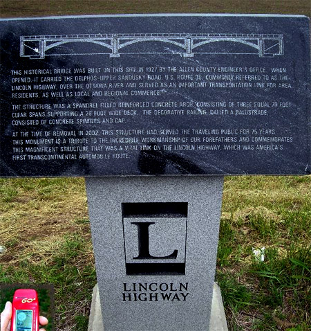
The marker below comemmorates the 1927 concrete bridge that carried the LH/Delphos-Upper Sandusky Road over the Ottawa River near Gomer, Ohio, taken by Stephen Shepherd.
The interesting monument below, probably overlooked by LH fans, was found at 1600 Plainfield Road in Joliet by a member cldisme.

According to the plaque at its base, this
life-size cold cast bronze sculpture of a 1915 Joliet road worker, seated on a hand-cut ceramic mosaic column, represents the historic Lincoln Highway and the birth of our modern day highway system. Also, included in the mosaic is an image of Abraham Lincoln medallion. The sculpture is dedicated to the men and women of the Will-Grundy Counties Building Trades Council and the construction companies of the Contractors Association of Will & Grundy Counties who make our roads possible.
On July 1, 1913, a group of automobile enthusiasts and industry officials led by Carl Fisher, created the Lincoln Highway Association (LHA), “to procure the establishment of a continuous improved highway from the Atlantic to the Pacific, open to the lawful traffic of all description without toll charges” and to be a lasting memorial to our 16 th president, Abraham Lincoln. Prior to the Lincoln Highway, the existing roads were nothing more than dirt paths, which became impossible to traverse even after the lightest rain. There were very few filling stations along the proposed route, few places to eat, and even fewer places to find lodging.
Since highway maps and signage did not exist, a uniform way of marking the highway became a necessity. A design was created that consisted of a concrete post, a blue arrow, and Lincoln’s image on a medallion. On July 8, 1928, the Boy Scouts of America installed the concrete sign posts next to 3,100 miles of roadway at all important turns and junction points from New York to San Francisco.
Check out the site for dozens more Lincoln Highway markers along (and sometimes far from) the road.
 Colo, Iowa, city clerk Scott Berka told me today that construction is progressing well at the Colo Motel, part of a wonderful “one-stop” restoration project in central Iowa. Painting is done and carpenters will start trimming next week, but furniture was just ordered today so it looks like it will be the first of the year before the motel reopens. Sounds like it will be ready in time for Springtime road trips!

 Click the map above for a full-size view of the Lincoln Highway.
Like this blog? You'll LOVE my books!Lincoln Highway Companion features detailed maps and places to eat and stay. Click the book to buy it on Amazon.
Click the map above for a full-size view of the Lincoln Highway.
Like this blog? You'll LOVE my books!Lincoln Highway Companion features detailed maps and places to eat and stay. Click the book to buy it on Amazon.
 Click the Greetings book below to purchase the ultimate guide to the history and route of the Lincoln Highway!
 Another fun book! The Ship Hotel: A Grand View along the Lincoln Highway recalls the greatest roadside attraction along the coast-to-coast road.
 And for those who LOVE diners, click the book below to purchase our completely updated guide to the history, geography, and food of Pennsylvania's Diners!


