This 1940s postcard advertised Wood’s Motel & Cafe – “ultra modern and steam heat” – on US 30 South in East Evanston, Wyoming. Has any part survived to visit during the 2008 LHA conference this June?
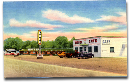
This 1940s postcard advertised Wood’s Motel & Cafe – “ultra modern and steam heat” – on US 30 South in East Evanston, Wyoming. Has any part survived to visit during the 2008 LHA conference this June?
Here’s a fun video of downtown DeKalb, Illinois, assembled from thousands of still images, which are themselves a bit distorted in day-glo colors. The view races up and down Lincoln Highway at a stop-action 180 mph to the tune of “High Way” by guitar legend Link Wray (sounding like a faster version of his big hit, Rumble). It’s a jumble of imagery, but anyone familiar with DeKalb will recognize many landmarks – even if seen only for a second.
The Wyoming State Parks and Cultural Resources has produced 20 short educational videos on the Lincoln Highway and posted them on veoh. Each one, typically a half-minute long, looks at a theme by using some facts or stories. The videos mostly use pans of still photos, many from the LHA archives. Click here for the series to start—once you do, they play consecutively, or see them all in outline form here. Here’s a screen capture of the Intro video (with a picture of the LHA’s Henry Joy and Austin Bement stuck in Nebraska):

Unless I’ve missed more of the content, there is no accompanying material on veoh or on the state website to tell how best to use these or what materials were referenced, leaving a gap if they’re for education, and leaving helpful resources uncredited. For example, quotes from Thornton Round about the Rock Springs camp and the sounds while camping at night are likely culled from Gregory Franzwa’s Wyoming book. Or in discussing Navigation, they quote from what is said to be an LHA road guide, but the distinctive “Turn left around the shearing pens” material is actually from a 1913 Packard guide to the road, which is quoted in my Greetings from the Lincoln Highway book.
Here are the episodes:
1) A Brief Introduction – :37
2) What Started It – :38
3) Henry B. Joy – :16
4) The Virginian – :15
5) US Army Convoy – 1:34
6) Rock Springs – 1:07
7) Laramie – :13
8) Road Hazards – :40
9) Plains Hotel – :15
10) Mechanics – :34
11) Wyoming – :42 (though the quote is about western Nebraska)
12) Crash – :29
13) Camp – :16
14) Railroad – :45
15) Church Buttes – :24
16) Navigation – :58
17) Evanston – :23
18) Fences – :50
19) Camping – :17
20) Flat Tire – :19
Here’s a sunny view of the Lincoln Highway to make us look forward to Springtime travel. It’s a railroad crossing in Illinois – can anyone identify where it’s at?

Automobile magazine copy editor Rusty Blackwell bought a 1967 MGB/GT Special through Craiglist this past fall. The challenge was getting it from San Francisco back to Ann Arbor, Michigan. His adventures with early snows and faulty fuel pumps are fun reading, even if much of it is along I-80. He does detour onto the Lincoln Highway briefly, such as Soda Springs, California; Rawlins, Wyoming; and Sidney and Gothenburg, Nebraska. He also took lots of photos. In all, his 2,300-mile trek that he hoped would take 4 days took 8. Click HERE for the first of his 9 posts. Here’s a screen shot of the opening page:

A story in the Southtown Star of suburban Chicago, Illinois, reports that the Lincoln Highway through New Lenox south of Chicago, will be remade over the next 18 months:
“This is the biggest news of the year. This is incredibly good news. This is the big one we have all been waiting for,” New Lenox Mayor Tim Baldermann said….
Upgrades include left-turn lanes at cross streets from Marley Road to Joliet Highway and in front of Lincoln-Way Central High School, plus temporary signals at Marley and new signals at Schoolhouse Road. [See Google Maps aerial view below.]

The work, which will greatly alter the Lincoln Highway roadscape, is in preparation for a Wal-Mart plaza across from Cooper Rd/Roberts Rd/Williams St. It looks like the development will fill one of the last large pieces of land along the LH there: note the house and surrounding fields on the north side of the road.
Oddly, this is just preliminary until permanent upgrades can be done:
All work is compatible with IDOT’s ultimate $80 million plan to make Lincoln Highway a fully improved five-lane road. Money for that massive construction project is not included in any budget at this time, said New Lenox village administrator Russ Loebe.
But these interim improvements “should buy the community quite a few years of smooth cruising” on Lincoln Highway, he said.
An insightful article also was published in Chicago Business News about the real estate deal. McVickers Development bought 73.5 acres from two sellers for a combined price of $18.9 million, then will sell it to Wal-Mart, Menards home improvements, Petco, Staples, Aldi, and other retailers. McVickers will likely lose money on the sale to Wal-Mart:
Typically, an anchor tenant such as Wal-Mart demands better financial terms because the company knows the developer can make it up by charging higher rents to the smaller tenants.
“In general, developers almost never, ever make money on the big boxes, and very often they lose money,” says Matthew Silvers, a principal in the Midwest brokerage arm of Northbrook-based Next Realty LLC, who represented McVickers in the acquisition.
Mr. Silvers says major retailers like Wal-Mart dictate how much they are willing to pay for land based on their forecast of a store’s profitability.
“They’ve got their own economic analysis, and that’s just going to be what they can pay for the land, and the developers have to deal with it,” Mr. Silvers says.
 The Times Bulletin of Van Wert, Ohio, ran a nice story about Webb’s one-stop that once served travelers north of Convoy in the far western part of the state. The story focuses on Larry Webb, whose family owned it. Larry is active in the LHA and Ohio LH activities.
At left, L-R, are the owners of the business around the time of purchase: Jenny Webb (Larry’s mother), Ola Wherry (grandmother), Myron Webb (father), and Harry Wherry (grandfather). Courtesy Larry Webb
Webb’s Hi-Speed Service Station, Restaurant, and Tourist Cabins actually had opened in 1931 under different owners, then in 1946, Webb’s parents and grandparents bought the business. They lived in the restaurant building along with Larry and his sister. When the road was widened in the 1960s, it took out the pumps, and with business already declining, they closed. The cabins are gone too, but the garage remains as does the restaurant, now a private home at the corner of Lincoln Highway and Convoy-Heller Road.

The Pittsburgh Post-Gazette reports that the Lincoln Highway Heritage Corridor has been awarded $49,340 to build giant roadside attractions along its 200 miles of the Lincoln Highway. The projects will be designed and built by vocational/technical school students in themes that honor the 250th anniversary of Pittsburgh and its region. This and another article in Pop City calls them “roadside giants,” and in fact, the LHHC’s Kristin Poerschke tells me they hope to give each of the vo-tech schools a copy of my and Sarah’s Roadside Giants and Roadside Attractions books as part of the grant to help them with their designs.

The LHHC is one of 100 regional and grassroots organizations and artists who received a total of $1 million in grants to help celebrate the anniversary. LHHC director Olga Herbert says they are honored because only 12 were selected from the 230 regional applications.
LHHC will collaborate with four career and technical schools in Greensburg/Hempfield, Latrobe/Ligonier, Somerset, and Bedford/Everest as well as with four communities along the Lincoln Highway, giving studens a chance to be creative and contribute something permanent to the communities:
The project envisions the sculptures to include items like vintage motor vehicles, historical figures like George Washington, images from popular culture like Texaco gas attendants and diner waitresses, old fashioned bicycles and gasoline pumps. The project will call upon graphic arts students to design the super sized metal sculptures. Other students will weld the metal, and design and printmaking students will be in charge of the brochures. Not to be left idle, the culinary arts students will bake gigantic models of the sculptures.
 The LHHC, one of 12 such heritage areas in the state, promotes economic development through tourism along the historic route of the Lincoln Highway in Westmoreland, Somerset, Bedford, Fulton, Franklin and Adams counties.
The [Newark] Star-Ledger photographed construction of the new Prudential Center in Newark, New Jersey, over a period of three years and has posted a time-lapse online. The arena, opened in November, is steps away from the intersection of Broad and Market, a famed crossroads and traditionally one of the most congested intersections along the Lincoln Highway. The view is looking south, with Broad (the Lincoln Highway) to the right. The video is by Bumper DeJesus: click the image to open the Star Ledger page, where you can then click to start the video..
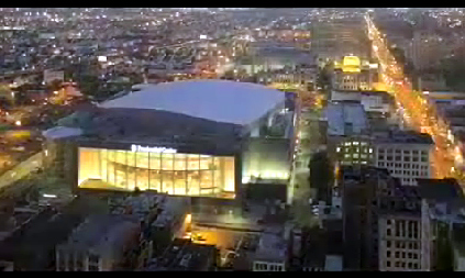
The Prudential Center hosts the NHL’s New Jersey Devils, Seton Hall Men’s Basketball, New Jersey Ironmen indoor soccer team, concerts, and special events. It is bounded by Edison Place to the north, Lafayette Street to the south, Mulberry Street to the east and Broad Street and City Hall to the west. Total cost was $375 million for a capacity of approximately 18,000 depending on the event. Outside, a 4,800 sq. ft. LED television faces Newark’s Penn Station. It was built where the large parking lot is seen on the Google map below. The Lincoln follows the yellow trace along Broad and Market streets.

The photo below (courtesy Jim Kearns, Manager, University of Wyoming Media Relations) shows sculptor Robert Russin and assistants working on the bust of Abraham Lincoln that they built in 1959 to honor Lincoln’s 150th birthday. Its location in eastern Wyoming also marked the highest point on the Lincoln Highway: 8,835 feet.

According to the Laramie Area Chamber and Albany County Tourism Board, Russin spent 11 months building the 4,500 lb. sculpture. The head’s 30 pieces were cast in Mexico City so that they could work in a constant favorable climate, then the bronze pieces were sent by rail back to Wyoming to be bolted together. The 13.5-foot-tall bust was then set atop a 35-foot-tall cut-granite base built by local crews. The inside is hollow to hold ladders and lightning rods. In 1969, the monument was moved (during a snowstorm!) about a half mile to a rest stop when I-80 opened between Cheyenne and Laramie. It’s now at the highest point along I-80: 8,640 feet.

The visitors center (above) has an informational panel about the monument and the Lincoln Highway. In 2001, the Henry B. Joy monument with four Lincoln Highway concrete posts was moved there from the Continental Divide interchange about a hundred miles to the west. Russin’s fascination with the president went beyond the monument: he named his second son Lincoln.

 Click the map above for a full-size view of the Lincoln Highway.
Like this blog? You'll LOVE my books!Lincoln Highway Companion features detailed maps and places to eat and stay. Click the book to buy it on Amazon.
Click the map above for a full-size view of the Lincoln Highway.
Like this blog? You'll LOVE my books!Lincoln Highway Companion features detailed maps and places to eat and stay. Click the book to buy it on Amazon.
 Click the Greetings book below to purchase the ultimate guide to the history and route of the Lincoln Highway!
 Another fun book! The Ship Hotel: A Grand View along the Lincoln Highway recalls the greatest roadside attraction along the coast-to-coast road.
 And for those who LOVE diners, click the book below to purchase our completely updated guide to the history, geography, and food of Pennsylvania's Diners!


