Posts Tagged ‘Wyoming’

More on Russin's Abraham Lincoln monument

December 16, 2007

The photo below (courtesy Jim Kearns, Manager, University of Wyoming Media Relations) shows sculptor Robert Russin and assistants working on the bust of Abraham Lincoln that they built in 1959 to honor Lincoln’s 150th birthday. Its location in eastern Wyoming also marked the highest point on the Lincoln Highway: 8,835 feet.

WY_Russin

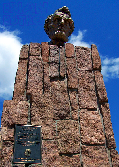
According to the Laramie Area Chamber and Albany County Tourism Board, Russin spent 11 months building the 4,500 lb. sculpture. The head’s 30 pieces were cast in Mexico City so that they could work in a constant favorable climate, then the bronze pieces were sent by rail back to Wyoming to be bolted together. The 13.5-foot-tall bust was then set atop a 35-foot-tall cut-granite base built by local crews. The inside is hollow to hold ladders and lightning rods. In 1969, the monument was moved (during a snowstorm!) about a half mile to a rest stop when I-80 opened between Cheyenne and Laramie. It’s now at the highest point along I-80: 8,640 feet.

WY_LincMon_I-80

The visitors center (above) has an informational panel about the monument and the Lincoln Highway. In 2001, the Henry B. Joy monument with four Lincoln Highway concrete posts was moved there from the Continental Divide interchange about a hundred miles to the west. Russin’s fascination with the president went beyond the monument: he named his second son Lincoln.

Wyoming Lincoln Monument Sculptor Dies at 93

December 15, 2007

The University of Wyoming reports that retired art professor Robert I. Russin has died at 93. His best-known sculpture, at least to Lincoln Highway fans, is the blocky bust of Lincoln atop Sherman Summit along the LH/I-80 in eastern Wyoming. It was created in 1959 to honor the sesquicentennial of Lincoln’s birth.

WY_Lincoln monument

The monument originally sat along the Lincoln Highway. When I-80 was completed over the rise in 1969, the monument was moved almost a half-mile east to the Summit Rest Area at the Happy Jack Road interchange, exit 323. Russin used 10 tons of clay and 11 months to complete the 12.5-foot-tall bronze base and bust.

Details of Russin’s life and work can be found in an LA Times obituary story.

Back on Board – Lincoln Highway Association

November 28, 2007

I’m once again on the Lincoln Highway Association board. I was a founding director in 1992, representing Pennsylvania, then left to raise kids and write books. I’m still doing those but will be filling a vacancy in an At-Large position. For the full list of directors, visit the LHA’s web site: www.lincolnhighwayassoc.org/about.

LHA banner

Plan to attend the LHA conference in Evanston, Wyoming, June 17-21, 2008.

Western Wyoming LH Corridor Threatened

November 18, 2007

Our friend RoadDog alerts us to a possible threat to the Lincoln Highway in western Wyoming. An article in the Casper Star-Tribune says there’s a good chance the undrivable Lincoln Highway remnant from Green River east to Rock Springs could be revamped into a connector road. Though the two cities are just 12 miles apart, I-80 is the only paved road connecting them, forcing commuters and other locals to compete with a rising tide of trucks brought on by the region’s oil and gas boom.

WY_Green River I-80

According to the article, “Two of the three proposed routes would begin at Green River’s east I-80 interchange and then follow the remnants of the old Lincoln Highway—which used to run between the two cities—north of I-80. A third route would start on the city’s south side and run south of the interstate, hooking up with U.S. Highway 191…. [U]nofficial cost projections to build an approximately 12-mile-long road have been estimated at about $2 million per mile, or around $24 million total. Officials expect the project to take a decade or longer to complete.”

Most dismaying for those concerned about preserving the LH’s roadscape, local leaders hope the new road will bring housing, business, and industry. Green River officials especially say the city has been hemmed in by Castle Rock and I-80 to the north, and steep undevelopable land to the south.

UPDATE 12/31/07: “Locals will help choose route” in the Caspar Star-Tribune.