Archive for the ‘highways’ Category

Buy-Way and Iowa Motor Tour this weekend

August 4, 2008

If you’re anywhere between WV and IL this weekend, make sure you visit some of the vendors along the Lincoln Highway Buy-Way (for IL click here). And if you’re anywhere near Iowa, join the 2008 River to River Motor Tour, sponsored by the Iowa Lincoln Highway Association. Dozens of vintage automobiles will be touring the Lincoln Highway from the eastern edge to the western edge of Iowa, but any and all types of cars or motorcycles are welcome on the family-friendly tour.

Above: The newly wiidened bridge between Omaha, Nebraska and Council Bluffs, Iowa, 1924. (Univ of Michigan, Special Collections Library, lhc2218)

FRI, AUG 8: Registration begins in Clinton at Main Ave. and Harding St, site of the old Lyons-Fulton Bridge. Visit the Calamus Pony Truss Bridge, lunch in Clarence, dinner in Amana, and overnight in Cedar Rapids.

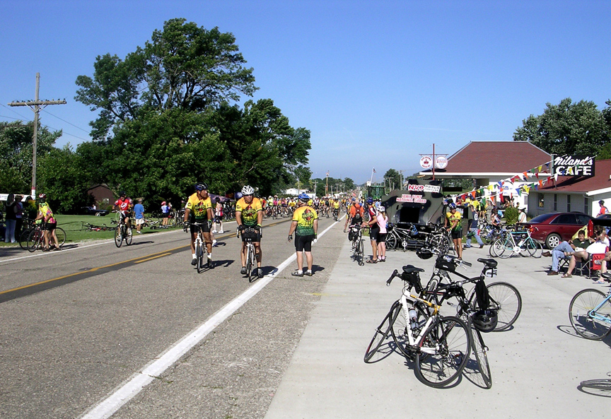
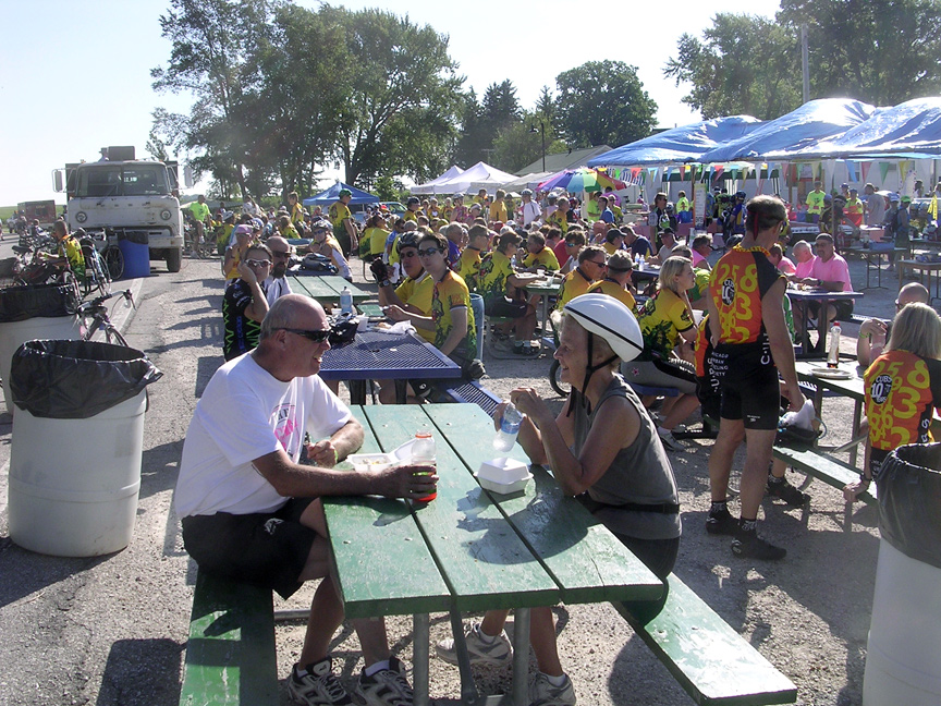
SAT, AUG 9: Youngville Cafe, Belle Plaine (see cafe below), Lincoln Highway bridge in Tama, lunch in State Center, Reed/Niland Corner cafe/motel, dinner in Boone, and overnight in Ames.

SUN, AUG 10: Ogden, Jefferson, Carroll, Denison, lunch in Woodbine, Missouri Valley, and Honey Creek.

For more information, contact tour director Jeff LaFollette at jefflaf@peoplepc.com or (563) 349-3047.

Lessons from a Route 66 motel makeover

August 1, 2008

Businesses along old 2-lanes such as the Lincoln Highway often struggle to compete with chains that locate at Interstate off-ramps, but Ron Warnick reports on his Route 66 News about a non-chain motel in Barstow, California, that has found a way a pretty basic way to attract tourists. The story from the city’s Desert Dispatch notes that a simple image makeover instantly began attracting travelers who otherwise were passing by. For all those independent motels struggling in the face of brand-names that feature oodles of amenities and AAA ratings, it’s proof that business can be improved by attending to the look and cleanliness of a place.

Their current property, the Topper Motel on West Main Street, is popular with people, mostly locals, owner Ken Patel said, needing a room for more than a couple of nights. But tourists running down Route 66 passed right by and rarely stopped to rent rooms for just a night or two.

The Patels’ solution: Renovate the west side of their property, paint it the appealing color of an orange Creamsicle and slap a new name, The Sunset Inn, over the office….

Ken said problems with longer staying customers on the Topper side of the business made him consider ways to bring in shorter-staying out-of-towners. He said the rooms where people stayed for weeks or months at a time were often unkempt, dirty and negatively effected the entire appearance of his motel.

The Sunset looks like a completely different motel from the Topper sitting next to it. The rooms are crisp and clean and the parking lot features a small courtyard and desert landscaping. Day Manager Bill Snyder said the remodel has been so successful with the Sunset that there are plans to give the Topper the same treatment soon.

A story in a 1950s diner industry magazine advised owners to pave their decrepit parking lots. Many diner owners howled at the idea, saying customers were more concerned with the food that the lot. Yes, if you know a restaurant has good food, you’ll overlook the shortcomings, maybe even calling them “charming,” but for those not familiar with a place – as most travelers aren’t – they’ll pass by a run-down motel or restaurant. In the same vein, would you buy a beat-up used car or one that looked cared for?

Videos trace Loneliest Road across Nevada

July 31, 2008

YouTube offers many views of US 50 in Nevada, dubbed The Loneliest Road in America, much of which follows the Lincoln Highway. Here are some time-lapse videos, heading west, that show that, if the road is not exactly deserted, it can be lonely.

Ely (look for the Hotel Nevada on the left at 0:42) westward almost to Eureka:

Then westward to Austin (arriving about 2/3 in):

Want those two trips all at once (but kinda fast)?

Since Eureka was lost in the editing of the above, maybe this will make up for it – all I’ll say is “Rawhide” gets sung at the town’s wacky Keyhole bar, right on the Lincoln Highway:

Cool stuff at the Lincoln Highway Trading Post

July 30, 2008

Don’t forget that the one-stop shop and official supplier of Lincoln Highway merchandise is the Lincoln Highway Trading Post. Here’s the mobile post at an event last year:

Books, shirts, pennants, maps, reprinted guides, and the driving CDs are available, and all sales benefit the Lincoln Highway Association.

Lincoln Highway Trading Post
425 Schroyer Ave. SW
Canton, Ohio 44702
330.456.8319
Fax: 330.456.8310
info@lhtp.com
http://www.lhtp.com

Business Hours
M-F: 7:30 AM – 4:30 PM (EST)

Customer Support Hours
M-F: 9:00 AM – 4:00 PM

Some on-the [gravel] road snaps from Sebak

July 29, 2008

As PBS producer Rick Sebak and crew followed the Lincoln Highway to the Pacific Ocean and back, he snapped lots of photos. Here are a couple from Utah.

And here’s a video clip they made while skirting the Great Salt Desert and Dugway Proving Ground:

Learn more about their travels and the forthcoming show, A Ride Along the Lincoln Highway, on Rick’s blog. Here are some of his other nationally themed shows:

Missionaries served SLC's municipal auto camp

July 28, 2008

An article by Ardis E. Parshal at keepapitchinin.org discusses the auto camp that sprung up on the west end of Salt Lake City, and Mormon missionary efforts there:

By 1921 it had the usual amenities found in any such western camp. In earlier years [Pioneer S]take leaders had noted the increasing thousands who spent time at the auto camp before passing along, and they realized they had an unusual service opportunity. That summer of 1921 they pitched a large tent at the camp and held church services, both on Sundays and during the week. Meetings were short and casual, and relied on music and the recitations of Sunday School children. The various ward choirs in the stake took turns providing music, and talented instrumental soloists offered their services. Stake officers provided brochures, sold copies of the Book of Mormon, and answered questions. Some 25,000 tourists were served in that first year alone.

In 1922, the project expanded, and stake members build a small chapel, open on one side to face rows of benches in the open air. And word began filtering back from missionaries in the field, that they had been welcomed into the homes of people who had stayed at Salt Lake’s auto camp and changed their opinion of the habits and character of the Mormons.

ABOVE: an image of the auto camp missionaries from the article, which identifies the men.
TOP IMAGE courtesy Russell Rein.

SLC and the 1860s Tabernacle were regular stops for most everyone motoring through Utah. As the author points out, and as seen in period travel journals, many wanted to see what Mormons looked like. Early auto traveler Harriet White Fisher was among those who stopped to see but concluded, “I could find no marks of identification that made them any different from other men in the East.”

Shady Bend to reopen with food & drinks

July 25, 2008

The Grand Island Independent reports that Shady Bend, a popular Lincoln Highway attraction on the east end of Grand Island, Nebraska, is being partially revived.

The mostly-cleared site has been bought by Craig Woodward, a grandson of founder H.O. Woodward. All that remains from the once-thriving site at US 30 and Shady Bend Road is the former Spanish-Revival gas station, which has been a tavern in recent decades. Still, the Shady Bend Gas Station, Grocery and Diner is listed in the National Register of Historic Places, and so Woodward, his wife Karen, and their daughter Jennifer Drapel are working to reopen the bar and restaurant. The business was started in 1929 and grew to include gas, food, and lodging in more than 30 tourist cabins, but the most famous of its attractions was a buffalo herd:

“I grew up thinking that everyone had buffalo in their yard,” Craig said.

He soon realized his grandfather and father’s diner was more than the average family business.

“Everyone I run into is excited to bring this place back,” he said. “They remember the buffalo, they remember eating there and hanging out there.”

For the past few years, the Shady Bend has been rented or vacant. Craig took sole ownership at the beginning of the year.

“We truly would like to have a gathering place again,” he said.

The state LHA newsletter “Linc” Across Nebraska has an in-depth story on it in its July 2008 issue by Lenore Stubblefield, who also provided the top image. She recalls a playground, sandy beach lake, tile tennis courts, and the restaurant’s most expensive meal, a T-bone stteak for 65¢. The cabins (later apartments) closed in 1981, The station was luckily spared in 1994 and 2004 road widenings, and will again be serving travelers.

Bike ride across Iowa following Lincoln Highway

July 24, 2008

Scott Berka, city clerk of Colo, Iowa, sent some great photos of the RAGBRAI® — The Des Moines Register’s Annual Great Bike Ride Across Iowa. Yesterday (day 4 of the week-long event), the bicyclists traveled the Lincoln Highway from Ames to State Center. He snapped the photos at the Reed/Niland Corner in Colo about 9:30 a.m.. They show the restored gas station, cafe, and area near the just-reopened motel. CLICK each one to see it larger.

RAGBRAI was started in 1973 as a 6-day ride (not a race) across Iowa by two Register columnists; it’s still planned and coordinated by the newspaper and is now hosted by the Register’s front-page cartoonist, Brian Duffy. The Des Moines Register naturally has numerous daily updates, including news that tacks strewn near Nevada, Iowa, caused at least 100 flat tires. Learn more by visiting the RAGBRAI® site or read a brief story at at WHO-TV.

Franzwa talks about his new Mormon Trail book

July 23, 2008

The Deseret News had a nice feature on Gregory Franzwa, author of 20 books including a state-by-state series on the Lincoln Highway. His new book, The Mormon Trail Revisited, retraces the 1846-47 route of the Mormon pioneers across the midwest and into Utah. The book mixes history with driving directions to the 1,400 miles of trails and country roads. Its 284 pages include more than 200 photographs of the trail and historic sites.

The article offers some insights into the author’s work and the trail:

“This exodus was the most amazing thing. There’s been nothing like it before or since. You think of the 2,500 humans and 500 wagons that left Nauvoo and camped at Sugar Creek. That has to be the biggest wagon train in history times 10.”

Franzwa and his wife, Kathy, who now live in Tooele, spent three years tracking the trail. They follow the mass exodus across Iowa, where the “adhesive mud so frustrated the pioneers’ plans to cross the Rockies that year that they had to hole up along the Missouri River. That must have been so discouraging for them.”

He then follows the trail that Brigham Young and the lead wagon train followed across the plains and into the Salt Lake Valley. “We found every single campsite,” he says.

His purpose in writing the guide was twofold. He wants to help people get there — “right in the traces. Right where the mules and oxen and wagon wheels left those scars. To get out of the car and stand in those ruts….

A second reason for the guide, however, is equally important, he says — to encourage preservation. “When a person has read that history, stood right on those pioneer pathways and driven or hiked the pioneer routes, it is unlikely that there will be much support for proposals which would damage or destroy the historic trails or sites.

To purchase the book ($24.95 paper, $39.95 cloth) or for more info, check Franzwa’s Patrice Press site patricepress.com/.

Free map & guide shows Ohio Buy-Way yard sale

July 22, 2008

A free Lincoln Highway BUY-WAY Yard Sale Travelers Guide is being distributed along the different routings of the Lincoln Highway through Ohio. The fourth annual BUY-WAY Yard Sale will take place August 7, 8 and 9. The guide features a map of all Lincoln Highway alignments and towns in Ohio, plus contains listings and ads for more than 50 of the larger group events. Guides can be found at participating businesses such as restaurants, attractions, and convenience stores.

Ohio Lincoln Highway Historic Byway Executive Director Mike Hocker says, “The guide is very helpful since many people are confused about where the Lincoln Highway ran — it did change alignments through the years from 1913 to 1928.”

In the 1920s, much of the old route in Ohio was marked US 30 but modern 4-lane improvements bypass the old towns and alignments. That means Ohio alone has roughly 350 miles of yard sales, community events, and festivals with lots of food, drink, and fun for kids. Last year saw more than 700 individual and organizational sales just in Ohio. Indiana and Illinois are participating too, and West Virginia’s 2.25-mile segment of the highway through Chester is also part of the BUY-WAY sale.

More information and a printable listing of yard sales and locations can be found at http://www.historicbyway.com (updated frequently). To get your guide ahead of time by mail (free for the price of a SASE), visit the travel guide page.