The Times Bulletin of Van Wert, Ohio, ran a nice story about Webb’s one-stop that once served travelers north of Convoy in the far western part of the state. The story focuses on Larry Webb, whose family owned it. Larry is active in the LHA and Ohio LH activities.
At left, L-R, are the owners of the business around the time of purchase: Jenny Webb (Larry’s mother), Ola Wherry (grandmother), Myron Webb (father), and Harry Wherry (grandfather). Courtesy Larry Webb
Webb’s Hi-Speed Service Station, Restaurant, and Tourist Cabins actually had opened in 1931 under different owners, then in 1946, Webb’s parents and grandparents bought the business. They lived in the restaurant building along with Larry and his sister. When the road was widened in the 1960s, it took out the pumps, and with business already declining, they closed. The cabins are gone too, but the garage remains as does the restaurant, now a private home at the corner of Lincoln Highway and Convoy-Heller Road.
As described yesterday, here’s last year’s Christmas light display at the home of Eric Rodemeyer in Marshalltown, Iowa, synchronized to the tune of fast-paced rock version of “Joy to the World”:
This year, the display was moved to the Marshall County Courthouse as a fundraiser for the Marshalltown Optimist Club. Here’s a story about it from Radio Iowa. The song is “Christmas Eve/Sarajevo 12/24” (an instrumental of “Carol of the Bells” with a bit of a bit of “God Rest Ye Merry Gentlemen”) performed by the Trans-Siberian Orchestra.
Marshalltown, Iowa, has a Christmas display in front of its courthouse—with lights timed to rockin’ versions of holiday tunes—as a fundraiser for the Marshalltown Optimist Club. The display began last year at the 7th Avenue residence of Eric Rodemeyer: 14,500 lights controlled by 96 computer channels timed to 7 repeating songs, each requiring up to 150 hours of programming, then were broadcast on 96.3 FM in front of his house. This video from last year features a serene version of “Silent Night” at his house.
This year’s display at the Marshall County Courthouse includes 21,620 lights controlled by 176 computer channels set to 8 repeating songs likewise on 96.3 FM. Lights are strung on eight 20-foot-tall trees, thirty 4-foot-tall spiral trees, plus strobes and a snow flake arch. Check the Marshalltown CVB web site for hours. Here’s the opening night introduction followed by a hard-rockin’ version of “Sleigh Ride,” then some views from a street cam.
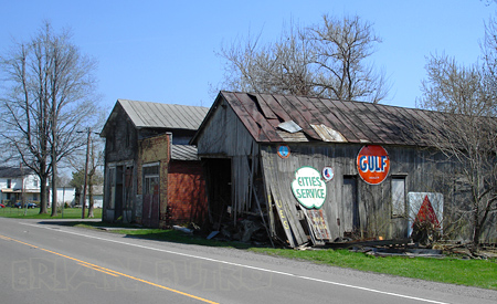
Can you name the location of this barn along the Lincoln Highway/US 30? Most fans photograph a sign a few miles east but speed past this interesting landmark. Looks like a store or two were adjacent. Need more clues?
The Rio Grande Railroad produced this black and white documentary in 1948 to promote the state’s wonders, and of course, encourage train travel. The film is a half-hour long but split into three parts. It only sometimes visits LH locations but is nonetheless an entertaining and nostalgic look at the state, tourism, and travel by steam engine almost 60 years ago.
1: Intro, Arches National Monument, horseback ride and spectacular rocks, Wasatch Mountains, Soldier Summit, Provo and Escalante Trail marker, Utah Lake, sugar beets, cherry blossoms. 10:18 min.
2: Copperton, Bingham (with horse-delivered mail), Utah Copper Company, worlds largest open cut mine, copper to electricity climax. 9:03 min.
3: Black Rock on Salt Lake, Saltair Pavilion and its Putt Putt railway, salt beds, highways to Ogden, cattle, sheep, train to SLC, D&RGW [Denver & Rio Grande Western]-WP station, streets, capitol, statues, Emigration Canyon monument, tabernacle, temple, cactus beehive (!), organ recital, ride home. 10:23 min.
The Pittsburgh Post-Gazettereports that the Lincoln Highway Heritage Corridor has been awarded $49,340 to build giant roadside attractions along its 200 miles of the Lincoln Highway. The projects will be designed and built by vocational/technical school students in themes that honor the 250th anniversary of Pittsburgh and its region. This and another article in Pop City calls them “roadside giants,” and in fact, the LHHC’s Kristin Poerschke tells me they hope to give each of the vo-tech schools a copy of my and Sarah’s Roadside Giants and Roadside Attractions books as part of the grant to help them with their designs.
The LHHC is one of 100 regional and grassroots organizations and artists who received a total of $1 million in grants to help celebrate the anniversary. LHHC director Olga Herbert says they are honored because only 12 were selected from the 230 regional applications.
LHHC will collaborate with four career and technical schools in Greensburg/Hempfield, Latrobe/Ligonier, Somerset, and Bedford/Everest as well as with four communities along the Lincoln Highway, giving studens a chance to be creative and contribute something permanent to the communities:
The project envisions the sculptures to include items like vintage motor vehicles, historical figures like George Washington, images from popular culture like Texaco gas attendants and diner waitresses, old fashioned bicycles and gasoline pumps. The project will call upon graphic arts students to design the super sized metal sculptures. Other students will weld the metal, and design and printmaking students will be in charge of the brochures. Not to be left idle, the culinary arts students will bake gigantic models of the sculptures.
The LHHC, one of 12 such heritage areas in the state, promotes economic development through tourism along the historic route of the Lincoln Highway in Westmoreland, Somerset, Bedford, Fulton, Franklin and Adams counties.
A fire broke out around noon today at the Mountain View Inn, a landmark along the Lincoln Highway 4 miles east of Greensburg, Pennsylvania. The fire was near a central tower, which was damaged, but no one was injured and the inn was set to reopen later today. Brief reports were in the Pittsburgh Post-Gazette and Pittsburgh Tribune-Review.
The hotel, opened in 1924 (as pictured above), sits between the Lincoln Highway and its bypass, US 30. The tower, now used for the logo of the inn, is a more recent addition.
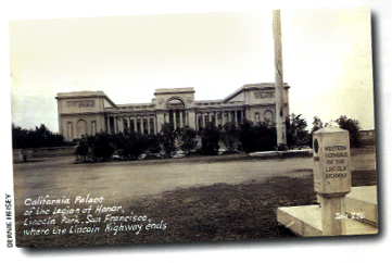
A couple interesting blog posts by John P. O’Grady recall how Lincoln Park, the western terminus of the Lincoln Highway, was once a graveyard. In fact, it still is! His first posting explains that the thousands who were buried in San Francisco’s City Cemetery were simply landscaped over a century ago so that a golf course could be built. (Yikes, don’t take any deep divots!) Over time, the rest of the area was cleared too. What happened to the thousands of wooden markers and granite monuments? They were tossed over the bluff known today as Lands Fill! (More disconcerting, the practice of discarding tombstones while leaving the bodies is apparently not at all uncommon.) The second posting explains that scavengers, under cover of night, search through the debris for treasures, and one of them, Dominic Camposanto, recently found a 1928 Lincoln Highway concrete post.
Above: The view from the Palace of the Legion of Honor, Lincoln Park, toward the Golden Gate Bridge.
Here’s the story from O’Grady’s blog:
Just recently, after an unexpected heavy rain, he discovered an original Lincoln Highway marker sticking out of the woody hillside like a phallus busted off an old Greek statue. Dom had no idea how that marker wound up in so unlikely a spot, nor did he care. He seldom takes interest in any stories attached to the articles he’s trying to unload, unless it can help make a sale. Anyway, with a prize like a Lincoln Highway marker, he didn’t need any story—all those collectors out there already had one. What they desperately lacked—and he could now supply—is the marker to go with that story. Thus Dom found an eager buyer over at the local university, a famous professor of climatology with a passion for Lincoln Highway memorabilia. The climatologist is very pleased with his purchase and has set it up in his backyard in the neighborhood around Rossi Playground. Now here’s where he could have used another story, one that might have revealed a little something about the history of this particular marker and—more importantly—something about the land upon which his own house is built. [Apparently, another graveyard.]
This could be any one of the 2,400 concrete posts placed along the Lincoln Highway in 1928, but don’t you think there’s a good chance that a LH post dumped over the hill from where the “Western Terminus” LH post once sat would be the same LH post??
Any California LH fans want to look up a climatologist living near Rossi Playground and ask to see the right side of his concrete post?
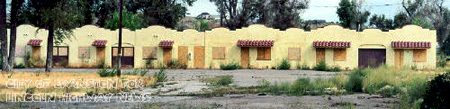
One of the stops during the 2008 Lincoln Highway Association conference in Evanston, Wyoming, will be the remains of the Sunset Motel. The string of six rooms—three with built-in garages—are on Bear River Drive, the LH on the east end of town near WY-89. Built in 1932 in Mission or Spanish Colonial Revival style, this portion of the motel has been saved—the question now is what to do with it.
I asked Jim Davis about the motor court. He’s Director of Administrative Services for Evanston and also on the Advisory Board for the Wyoming Main Street Program, on the Advisory Board for the National Trust for Historic Preservation, a staff member for the Evanston Historic Preservation Commission, and a founding member and past chair of Tracks Across Wyoming.
The good news about the Sunset Cabins is that they are still standing. Bad news, we still haven’t figured a new use for them and they remain threatened. The Evanston Preservation Commission had them listed as locally significant; however this does nothing to protect them as Evanston does not have a demolition ordinance or any such preservation ordinance. The cabins remain with the ownership of the city and we are still trying to figure a way for us to find adaptive reuse in order to secure their future. A little over a year ago we placed a restored Lincoln Highway marker at the site in order to draw attention as to the significance of this site.
One of the problems with any restoration effort is how to adapt and reuse. Jane Law, City of Evanston Urban Renewal Coordinator (and who kindly arranged for these photos), says, “We have heard artist studios, concessions, but nothing that gets everyone stirred up enough to get something done…. It would truly be a shame to ever lose them, they are quite unique and really pretty cute. The state is restoring some motor cabins in Ft. Bridger, so maybe we can get some more interest there for them to come a little further west.”
Another issue is having the resources for every worthy project:
At present we really have our hands full restoring, rehabilitating, and preserving our wonderful and unique roundhouse and railyards site…. We are also trying to rehabilitate a historic hotel in our historic downtown; that has been a very long process with years of delay. Our Renewal Agency just purchased what remains of our downtown theater. That will be quite a project in itself. There was a terrible fire there in May and the building is just a shell now, but not wanting a hole in the block or a mini parking lot, we stepped up and will try to make that a viable business for our downtown. So we have our hands full, BUT the Sunset Cabins are something our Historic Preservation Commission should address. I do think those coming next year [to the LHA conference] will like them and could play a big part in thinking of a reuse. [my emphasis]
Jane also sent a detailed and fascinating hisstorical survey of the site that I’ll review soon in a separate post.
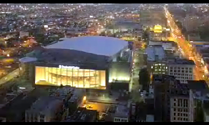
The [Newark] Star-Ledger photographed construction of the new Prudential Center in Newark, New Jersey, over a period of three years and has posted a time-lapse online. The arena, opened in November, is steps away from the intersection of Broad and Market, a famed crossroads and traditionally one of the most congested intersections along the Lincoln Highway. The view is looking south, with Broad (the Lincoln Highway) to the right. The video is by Bumper DeJesus: click the image to open the Star Ledger page, where you can then click to start the video..
The Prudential Center hosts the NHL’s New Jersey Devils, Seton Hall Men’s Basketball, New Jersey Ironmen indoor soccer team, concerts, and special events. It is bounded by Edison Place to the north, Lafayette Street to the south, Mulberry Street to the east and Broad Street and City Hall to the west. Total cost was $375 million for a capacity of approximately 18,000 depending on the event. Outside, a 4,800 sq. ft. LED television faces Newark’s Penn Station. It was built where the large parking lot is seen on the Google map below. The Lincoln follows the yellow trace along Broad and Market streets.
Click the map above for a full-size view of the Lincoln Highway.
Like this blog? You'll LOVE my books!Lincoln Highway Companion features detailed maps and places to eat and stay. Click the book to buy it on Amazon.
Click the Greetings book below to purchase the ultimate guide to the history and route of the Lincoln Highway!
Another fun book! The Ship Hotel: A Grand View along the Lincoln Highway recalls the greatest roadside attraction along the coast-to-coast road.
And for those who LOVE diners, click the book below to purchase our completely updated guide to the history, geography, and food of Pennsylvania's Diners!
 The Times Bulletin of Van Wert, Ohio, ran a nice story about Webb’s one-stop that once served travelers north of Convoy in the far western part of the state. The story focuses on Larry Webb, whose family owned it. Larry is active in the LHA and Ohio LH activities.


 The LHHC, one of 12 such heritage areas in the state, promotes economic development through tourism along the historic route of the Lincoln Highway in Westmoreland, Somerset, Bedford, Fulton, Franklin and Adams counties.