The popular Niland’s Cafe in Colo, Iowa, will reopen December 5 and operate three days a week through the winter.
The Nevada Journal revealed the joint plan between the city of Colo, which owns the historic Reed-Niland property, and the Colo Development Group, which manages the property for the city:
Ben Weir, president of the development group, said Missy Bitters, of Colo, will be overseeing the day-to-day operation of the restaurant…. Previously, the city and development group have leased the restaurant to those who have operated it…. Weir said the development group won’t heavily advertise the opening at first, because “we want to allow Missy to get in and get organized … and get her feet wet.”
Bitters said hours of operation will be 6:30 a.m. to 9 p.m. Friday and Saturday and 7 a.m. to 3 p.m. Sundays. She said one of the things the restaurant will bring back from the past is the loose meat sandwiches that historic owner John Niland made popular for the restaurant.
Above is Colo city clerk Scott Berka at the Niland’s Cafe counter.
Scott Berka alerts us that the woman who was running Niland’s Cafe in Colo, Iowa, had some medical issues and closed the cafe after Labor Day. The Colo Development Group is hiring a manager to operate it, hoping to reopen shortly after Thanksgiving. Winter days will be Friday, Sat., Sunday, then likely back to daily except Monday come Spring. The motel is still for rent at $49.99 per night.
Until the acafe reopens, those interested in renting a room should call the Colo Development Group office at (641) 377-2278. Once the cafe is open again, the number to call will revert to the cafe: (641) 377-3663.
My next book, Lincoln Highway Companion, lists places to eat, stay, and visit from coast-to-coast. It also features maps and must-see lists for every state. The guide was intended to coincide with Rick Sebak’s PBS program A Ride Along the Lincoln Highway but with a house move and some family passings, I delayed the book till 2009.
The design proofs just arrived a few days ago. Above are pages from Nevada, Iowa, and the “feeder route” or branch through Washington DC. As you can see, they feature a mix of maps, photos, and brief place descriptions. Some knowledgable LH friends are helping to check the pages, and I’ve contacted many of the places listed for updates. We’re already working on improvements to the maps so there’s LOTS to do this week.
Lincoln HIghway Companion is listed on Amazon but won’t be available till Spring 2009. For now, you can find statewide maps and route descriptions in my Greetings from the Lincoln Highway book, also on Amazon.
YouTube features many videos about RAGBRAI, the annual bicycle tour across Iowa, which this year followed much of the Lincoln Highway. In this first one, even President Lincoln gets into it at 3:09. (Can any non-Iowa readers identify the location of the statue?
In this one the riders dip their wheels in the rivers, just like LH travelers did at the oceans!
The July 2008 issue of Throttler Motorcycle Magazine had an article about motorcycling the Lincoln Highway through Iowa. I contributed the images and Craig Ruegsegger wrote the story.
For more information, contact President & Publisher Roderick Kabel at roderick@throttlermagazine.com or visit www.throttlermagazine.com/.
The interestingly named town of Nevada, Iowa, will celebrate its 25th annual Lincoln Highway Days this weekend – August 22, 23, and 24, 2008. The event includes a carnival, teen and adult dance, rodeo, pig wrestling, and a big parade.
Nevada is east of Ames and just west of the popular Niland’s Cafe/Colo Motel. The original Lincoln Highway Days in 1983 was actually called the Old 30 celebration to coincide with the completion of a railroad overpass west of town.
Friday night is the Adult Dance and the Teen Dance and the Rodeo. The Craft, Flea Market, and the Varied Industry building also will be open. The Parade is Saturday at 10 a.m. and the theme is “25 Years of Family Fun on Lincolnway.” Event co-founder Keith Cooper will be honored. The carnival and food court run all three days, with most activities on the Story County 4-H fairgrounds at 2nd St. and I. Avenue
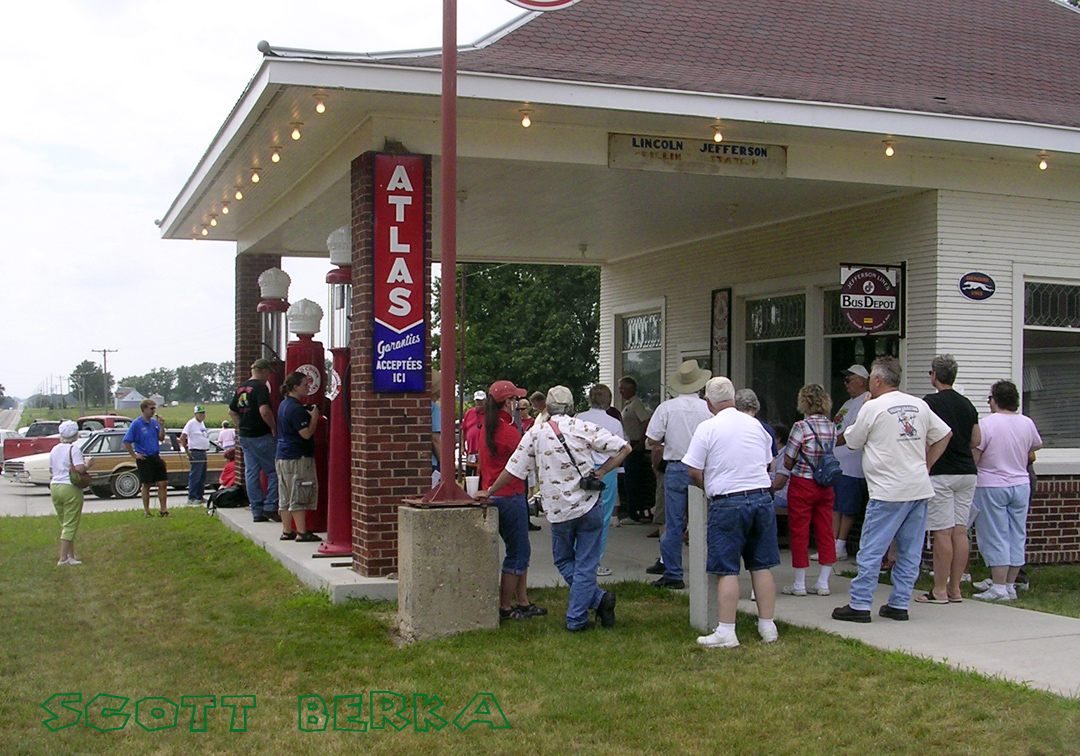
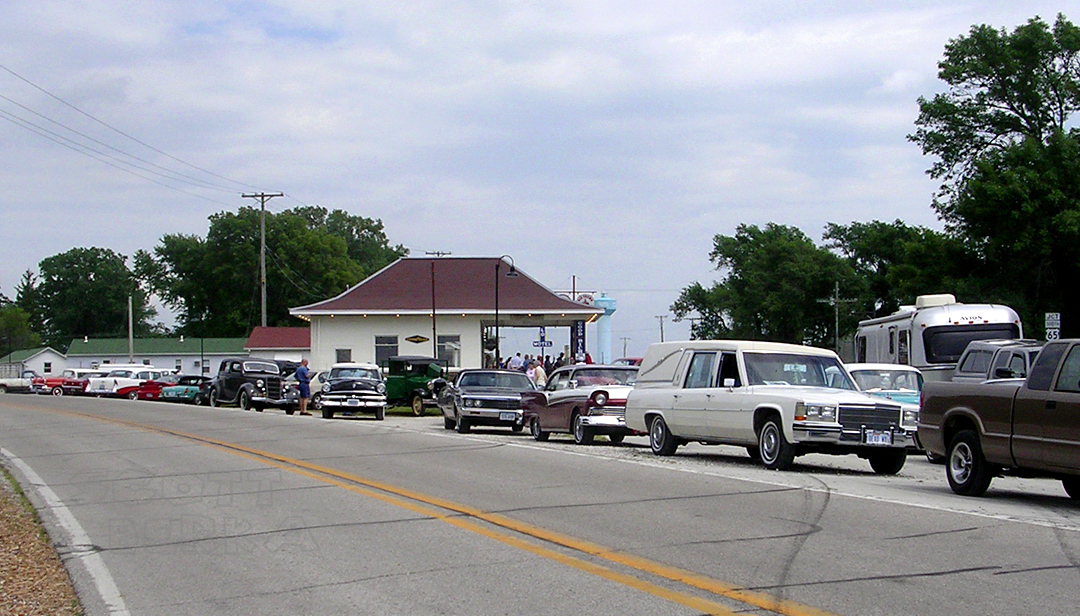
Judging by the glowing follow-up newspaper stores, the 2008 River to River Motor Tour sponsored by the Iowa Lincoln Highway Association was a big success. The 3-day tour started Friday morning in Clinton and crossed the state, ending Sunday afternoon at Missouri Valley. Tour director Jeff LaFollette said there were 55 vehicles and about 110 people in the caravan as it moved west.
Two photos from Colo City Clerk Scott Berka show tour-goers at Reed/Niland Corners, home to a restored cafe, gas station, and motel. The café had pie and coffee for the travelers on Saturday. The view of the gas station shows LaFollette (in blue shirt) giving instructions by microphone. The second shows the road behind the complex lined with vintage vehicles. CLICK them to see LARGER:
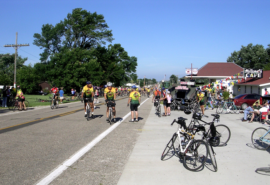
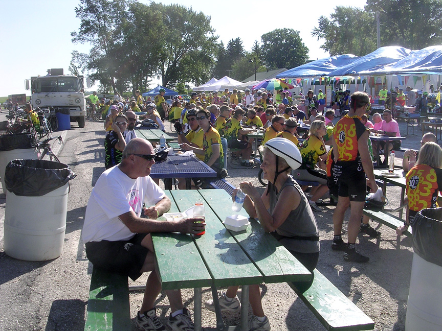
Scott Berka, city clerk of Colo, Iowa, sent some great photos of the RAGBRAI® — The Des Moines Register’s Annual Great Bike Ride Across Iowa. Yesterday (day 4 of the week-long event), the bicyclists traveled the Lincoln Highway from Ames to State Center. He snapped the photos at the Reed/Niland Corner in Colo about 9:30 a.m.. They show the restored gas station, cafe, and area near the just-reopened motel. CLICK each one to see it larger.
RAGBRAI was started in 1973 as a 6-day ride (not a race) across Iowa by two Register columnists; it’s still planned and coordinated by the newspaper and is now hosted by the Register’s front-page cartoonist, Brian Duffy. The Des Moines Register naturally has numerous daily updates, including news that tacks strewn near Nevada, Iowa, caused at least 100 flat tires. Learn more by visiting the RAGBRAI® site or read a brief story at at WHO-TV.
Folks across Iowa continue to suffer from the storms and flooding of a few weeks ago, at a scale incomprehendible to us outsiders. Cedar Rapids alone had 1,300 city blocks under water! J.R. Manning sent links to photos that Iowa DOT took at the time, many showing US 30 where it is either atop or near the Lincoln Highway. Above and below are a few or click here for the complete galleries. Here’s an update on current conditions from Van & Bev Becker:
The Cedar River cuts through the center of Cedar Rapids with the government buildings on an island in the center of town. The 1st Ave Bridge ( 1913-1916 route of the LH) was totally under water including the railings. The 2nd Ave Bridge (1916-1928 route of the LH) was also totally under water including the railings. At the flood peak, ALL bridges in Cedar Rapids, including I-380, were closed. One railroad bridge, loaded with freight cars, washed away. The city government and county government offices are now scattered all around town. Today, all bridges are again open to normal traffic. There are huge piles of flooded and damaged carpet, desks, furniture, files, food, coolers, etc lining the downtown streets and lower neighborhoods.
How did the Lincoln Highway sites and landmarks fare? Quite well thank you.
• The beautiful Coe College campus where we held our natl LHA conference 2 years ago (2006) escaped any flood damage.
• The 1st and 2nd Ave Bridges over the river are back to normal use.
• The huge Grant Wood stain glass window, in the Veteran’s Memorial Building – north side of the 2nd Ave bridge – shows a few cracks and a bit of bowing. This historic treasure can be repaired.
• The Maid Rite (loose meat sandwitches) on 1st Ave West – 6 and a half blocks from the river – was under water to the ceiling. Everything inside is a loss. It is too soon to know if this small business will survive.
• The 1927 Roosevelt Hotel on 1st Ave and 2nd Street is still closed, no power yet. Water filled the basement and first floor.
• The Quaker Oats production facilities (largest cereal mill in the world ) will be closed for a few months. They had water up to the second flood in places. The surrounding railroad tracks and lack of power will be a problen for too but they will reopen.
• There were no LH markers (other than painted telephone poles) affected.
• There were no LH kiosks affected.
• There were no LH road signs affected.
• The Iowa LHA chapter is still going ahead with our 3-day motor tour (Aug 8-9-10) crossing the state with the first overnite stop in Cedar Rapids.
• Highway 30, I-80 and the mainline of the Union Pacific Railroad are all reopened and flowing as normal.
It will be 5-10 years before the city fully recovers from a 500-year flood. We are working hard and fast – by the end of the summer a quick casual tourist may never spot evidence of the flood.
In anticipation of the 36th annual RAGBRAI®, the “Register’s Annual Great Bicycle Ride Across Iowa,” Des Moines Register Editorial Cartoonist (and race host) Brian Duffy has been checking out the route the past week. The yearly week-long bicycle ride through Iowa is sponsored by The Des Moines Register; the 2008 route will follow much of the Lincoln Highway from July 20-26. RAGBRAI® is the longest, largest, and oldest touring bicycle ride in the world. Click HERE to see a list of Duffy’s daily posts. For a map you can zoom in on, plus photos and videos, visit Duffy’s blog (screen shot below):
Although Iowa seems flat to outsiders, this year’s day 2 alone has more than 5,000 feet of climb in its 80-mile length. The end of that day will bring riders their first views of Lincoln Highway and Burma Shave signs just west of Jefferson.
RAGBRAI was started in 1973 as a 6-day ride (not a race) across Iowa by two Register columnists; it’s still planned and coordinated by the newspaper. This year will launch from Missouri Valley but not pick up the LH till Jefferson, hit it from Ogden through Boone, again some of it in Ames, Nevada, Colo, and State Center, cross it at points in Le Grand and Tama, then pick it up in Chelsea through Belle Plaine, meet it through Lisbon/Mt. Vernon, and finally cross it at Mechanicsville. The bike route will be nearby or parallel the LH for much of the time, though not always along it.
Click the map above for a full-size view of the Lincoln Highway.
Like this blog? You'll LOVE my books!Lincoln Highway Companion features detailed maps and places to eat and stay. Click the book to buy it on Amazon.
Click the Greetings book below to purchase the ultimate guide to the history and route of the Lincoln Highway!
Another fun book! The Ship Hotel: A Grand View along the Lincoln Highway recalls the greatest roadside attraction along the coast-to-coast road.
And for those who LOVE diners, click the book below to purchase our completely updated guide to the history, geography, and food of Pennsylvania's Diners!


 Scott Berka alerts us that the woman who was running Niland’s Cafe in Colo, Iowa, had some medical issues and closed the cafe after Labor Day. The Colo Development Group is hiring a manager to operate it, hoping to reopen shortly after Thanksgiving. Winter days will be Friday, Sat., Sunday, then likely back to daily except Monday come Spring. The motel is still for rent at $49.99 per night.