Posts Tagged ‘roads’

Events for Lincoln Highway Around Chicago book

April 2, 2008

With some big projects keeping me busy, I’ve not been able yet to review Cynthia Ogorek’s new book from Arcadia, The Lincoln Highway Around Chicago, but here’s a list of book-related events to look for over the next few months.

IN_LHA_lhc1321.jpg

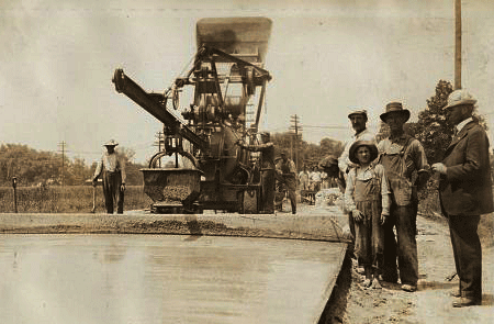
Above, the LHA labeled this 1927 photo as “an important intersection with the pavement widened for safety, 25 miles west of Chicago Heights, Illinois. Courtesy University of Michigan, Special Collections Library, lhc1321.

April
7 at 10 am. “The Dave Nemo Show,” XM Satellite Radio, Open Road 171. Live phone interview.

14 at 7 pm. South Holland Public Library, 16250 Wausau Ave, South Holland, IL, (708) 331-5262. Program and book signing.

19 at 10:30 am. South Suburban Heritage Association Annual Conference, St. Paul Community Church, 18200 Dixie Hwy, Homewood, IL, jryegdorf@ameritech.net


May
10 at 11:30 am. Indiana-Lincoln Highway Association Spring Meeting and Luncheon, Teibel’s Restaurant, Schererville, IN. Contact: in.director@lincolnhighwayassoc.org

17 All day. South Holland “Onion Fest,” American Legion Hall, 443 157th St, South Holland, IL, (708) 596-2722.


June
7 or 8 time TBA. Printers’ Row Book Fair, Chicago, IL, at Arcadia Publishing booth. Contact Cynthia at sealuna@juno.com

13 at 1 p.m. Calumet City Historical Society, 760 Wentworth Ave, Calumet City, IL, (708) 862-8662.


July
12th at 1 pm. Lake County Public Library, Merrillville, IN. Contact Susan Killin (219) 7769-3541 x336 or skillin@lakeco.lib.in.us


August
TBA Gourmet Junction, Plainfield, IL. Contact Cynthia at sealuna@juno.com


September
16 time and place TBA. South Holland Historical Society, South Holland, IL, (708) 596-2722.

Contact names and emails are supplied if you’d like to confirm the arrangements.

Indiana Curriculum to Spotlight Lincoln Highway

November 8, 2007

A Lincoln Highway curriculum unit is being prepared by the LHA Indiana chapter. “Indiana’s Historic Lincoln Highway” will offer a complete 2-week course for grades 3 and 4, formatted to Indiana State Standards. Project Leader Joyce Chambers says a team has been working for a year and a half gathering information and creating hands-on activities for topics such as maps, math, art, music, language, and science. Field research is wrapping up for this year as colder weather approaches.

IN_UM concrete
Above: Pouring the last concrete between Osceola and Mishawaka, Indiana. (Univ of Michigan, Special Collections Library, lhc2276)

The kit will likely contain a Teacher’s Guide, Student Booklet, DVD history of the road, possibly some model race cars (a nod to Carl Fisher’s connection to the Indy Speedway), a LH BINGO Game, and images of the road in Indiana, all in a sturdy tote bag. Sections may include Overview, Construction, Bridges, Tollhouses & Mile Markers, Travelers, Accommodations, Workers along the Road, Fun Sheets, Timeline, Lincoln Highway Sites, Glossary, Bibliography, Evaluation, and information on the LHA. The South Bend Community School Corporation’s Print Shop will donate the printing.

IN_UM_Ideal Sec 
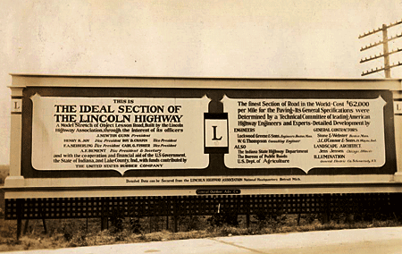
Above: A billboard on the Lincoln Highway’s famous Ideal Section in western indiana, 1927. (Univ of Michigan, Special Collections Library, lhc2793)

Three or four schools will test a pilot version for the 2008-’09 school year, then it will be evaluated and revised for release in 2009-’10 to public libraries and schools along the LH. Further suggestions will be incorporated into a final version available to all Indiana schools, including homeschoolers and private/parochial. It will be available through “check out” at the Center for History Education Department, where other such kits are stored for teachers. A similar highway-themed curriculum is Traveling the National Road Classroom Activity Program.

A kit and PowerPoint show will be presented at the LHA’s 2008 conference, and a presentation at the ’09 event will include feedback from the test year. It sounds like a solid plan, and a model program for other LH states.

IN_UM_curve
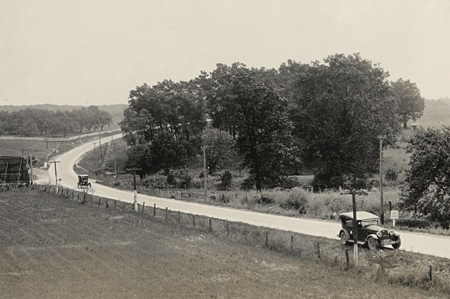
Above: The LHA Packard touring through Indiana, 1925. (Univ of Michigan, Special Collections Library, lhc2313)

For more information, or to make suggestions about content, contact Joyce Chambers at joycechambers47@aol.com (574) 272-5374.

Click the Lincoln Highway Map

November 7, 2007

For those not familiar with the route of the Lincoln Highway, I now have a map available based on the one in my Greetings book. Click the thumbnail below or the really tiny one to the right and you’ll get a US map up to 19 inches wide, just like this one:

Butko Greetings LH map - Med

The first generation represents the “Proclamation Route” of 1913. Towns like Trenton, NJ; Marion, OH; and Ogden, UT were quickly removed (though Ogden would later be put back on).

You’ll also see the Colorado Loop, which the LHA soon regretted but nonetheless approved of for two years. Note also that there were two ways around Lake Tahoe in eastern California. West of Sacramento, the 1928 rerouting is being debated of late as to whether the change was officially endorsed by the LHA board. It’s included because that’s where the LHA’s concrete posts went in 1928.

The first tally of the Lincoln Highway’s length was 3,389 miles (including Camden and Marion but not Ogden), though it would always be in flux due to bypasses and realignments. More than a decade later, the now more-famous US Route 66 would run 2,448 miles from Chicago to Los Angeles (though it likewise would vary in length).