Posts Tagged ‘maps’

In Search of the Golden Arrow Diner

November 28, 2018

LINCOLN HIGHWAY NEWS IS A BLOG BY BRIAN BUTKO

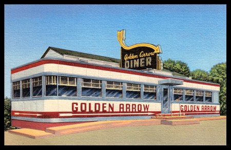
The Golden Arrow Diner postcard has long been a favorite of Lincoln Highway and diner fans. The back lists it as “Lincoln Highway, US No 1, Langhorne.” After having written books on the Lincoln Highway in Pennsylvania, and Diners of Pennsylvania, I still had no idea exactly where it was located.

PA-Langhorne-Golden Arrow.jpg

The original books were written pre-Internet, so we now have the world of online resources. But it’s not THAT easy: one site, for example, listed it in 1953 at “City Line ON Roosevelt Blvd, Trevose,” another said “City Line ABOVE Roosevelt,” and yet another, “Roosevelt Blvd NORTH OF City Line” One post said across from a cemetery, another said the cemetery was behind it.

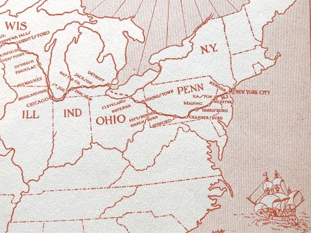
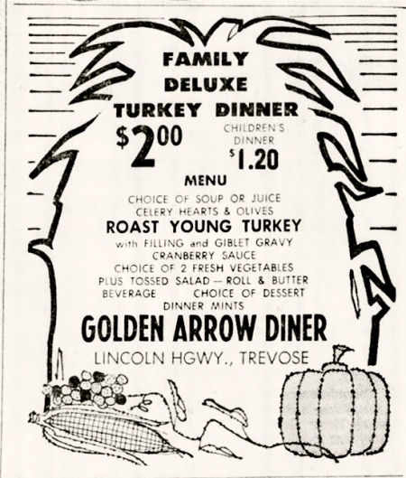
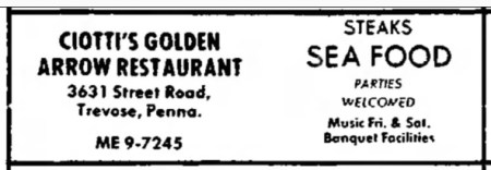
Best I can tell, it was just southwest of Street Road (which is now Old Street Road, dead-ending at newer, wider Route 1). The diner’s name was registered by Emilio Ciotti in 1951. As the postcard back notes, the Golden Arrow was build by Comac in Irvington, N.J., a relatively rare make.

gettyimages-1954.jpg

Golden Arrow Diner, 1954. © Getty Images.

map.jpg

ad58.jpg

1958

ad60.jpg

1960

The diner moved in 1967, though not far, and became the kitchen for a new, bigger venture of Emidio or “George” and Lena Ciotti: the Golden Arrow Restaurant & Cocktail Lounge Of Trevose, 3631 Street Road, Cornwells Heights, Pa. Check the map above for both old and new locations.

The Bucks County Courier Times of Nov. 17, 1967, said this new location had a plush dining room, cocktail lounge, wall-to-wall carpeting, bay window, and large aquarium. An in-house jazz trio of piano, drums, and upright bass provided “the Philadelphia sound, if you know what that is.”

ad71.jpg

1971


In recent years, it was sold and remodeled into the Stadium Bar & Grill. This Google Street View shows what may be the diner sticking out of the larger building:

Stadium 2014.jpg

Unfortunately we can no longer check — the Stadium was demolished in 2015, replaced by a park. Now, barely a block away, the Metro Diner serves customers from a modern shopping plaza.

Final odd note — in 1994 there was an ad looking for workers for a Golden Arrow Diner on Rts 11 & 15, Shamokin Dam, Pa., and then a flurry of these ads in 1997. Then that trail goes cold too, more roadside history lost to time….


Driving the Lincoln in 1919 ~ part 3: good roads

May 23, 2018

Beatrice wrote that they followed the Lincoln Highway to Pittsburgh — making it sound like they’d been on it since NYC —  but they didn’t pick up the LH until Chambersburg, Pa., on the way to their third overnight stop in Bedford, Pa.

map.jpg

“One of the all-absorbing pleasures in contemplating a long trip is to map out your route. You hear how all your friends have gone, or their friends, then you load up with maps and folders, especially those published by all the auto firms and tire companies, you pore over the Blue Book of the current year, and generally end by going the way you want to go, through the cities where you have friends or special interests. This is exactly what we did.

“As the trip was to be taken in mid-summer, we concluded to take a northern route from Chicago, via Milwaukee, St. Paul, Fargo, Billings, Yellowstone Park, Salt Lake City, Ogden, Reno, Sacramento, to San Francisco (see map), and, strange to relate, we followed out the tour as we had planned it. With the exception of a few hot days in the larger cities and on the plains, and, of course, in the desert, we justified our decision. As I have stated, we drove 4154 miles, through sixteen states and the Yellowstone Park, in thirty-three running days, and the trip took just seven weeks to the day, including seventeen days spent in various cities, where we rested and enjoyed the sights….

“We followed the Lincoln Highway to Pittsburgh, and have only praise to offer for the condition of the road and the beauty of the small towns through which we went. Of all the states that we crossed, Pennsylvania stands out par excellence in good roads, clean, attractive towns, beautiful farming country and fruit belts, and well-built, up-to-date farm buildings. In other states we found many such farms, but in Pennsylvania it was exceptional to find a poor, tumble-down farmhouse or barn. The whole state had an air of thrift and prosperity, and every little home was surrounded by fine trees, flowers, and a well-kept vegetable garden.

“Our objective point was the charmingly quaint town of Bedford, and the Bedford Arms. This part of Pennsylvania was more beautiful than what we had been through, and every mile of the day’s run was a pleasure.”


More map mysteries – Lincoln Hwy curves in PA

December 19, 2008

Ken Ruffner wrote me with a question regarding an image in my book The Lincoln Highway: Pennsylvania Travelers Guide. It’s the historic photo on page 153 (1st ed., 1996) of the Horseshoe Curve above McConnellsburg, Pa.

pa_mcconcurves

I had said the view is looking west to McConnellsburg, with the new road on the right. Ken wrote, “but then the road on the right is lower than the one on the left when in fact it really is higher on the hill… this photo doesn’t register with me…. could you please help me out with this so I can let it go… a friend of mine and I left the area with more questions than we started out with.”

pa_mccon-aerial-wide

Above is an aerial view showing modern US 30 as a straight line and the old LH/US 30 curving up the mountainside. They still join at a prominent horseshoe curve but I wrote in my book that the photo was along the old curvy road, about where the “y” is in “Lincoln Way E.” I had discerned this by walking the old road, but after Ken inspired me to look at the aerial view, I realized the entire curve survives, though only partially driveable. The “lost” remnant is on the west/left side of Old 30/Lincoln Way E – it’s much more visible in the close-up below.

pa_mccon-aeril-close

I see where Ken could be confused, but the new curve was broader and hence closer to the drop off. Look below at my proposed routings: red is the original (we’ll call it 1913 for LH reference), purple is the new (1924) curve. The original (red) road/curve that sat higher would have survived the 1924 reshaping, as seen in the historic photo, but was erased when the current road split the horseshoe about 1970.

pa_mcconmylines

The topo maps show the evolution, the first showing the original curve as a sharp turn, the second showing the broader 1930 revision.

pa_mcconnellsburgmaps

The last mystery is the little road south of all this that likewise has a turnoff to the east. I marked it in blue. Is it an earlier alignment? A detour during construction in 1924? Or 1970? Or was there a house there at some point?

Note about exploring the 1924 alignment  — the road in my 1992 photo is blocked and walking it may be trespassing now, though perhaps it’s just blocked to stop traffic. When I walked it back then, it was beautiful and thrilling to be discovering an old alignment. What an eerie feeling to stand where thousands of cars once chugged up the mountain.

81st Anniversary of Federal Highway Numbering

January 2, 2008

“Windy City Road Warrior” Dave Clark (author of Exploring Route 66 in Chicagoland and Route 66 in Chicago) posted an interesting story about the 81st anniversary of the federal highway numbering system. Although the highway plan was finalized in November 1926, the public announcement was delayed until January 1, 1927. Clark references a Chicago Tribune article from January 2, “U.S. Marks Ten Main Roads With Route Numbers” that explains the system that has been used ever since for federal highways: east-west route have even numbers, north-south have odd, with lowest numbers in the north and east. The 10 main transcontinental route numbers ended in 0, and the main N-S route numbers ended in 1 or 5. A tentative plan had been submitted to the American Association of State Highway Officials (AASHO) in November 1925, followed by a year of wrangling and revisions. Standardized signage was also adopted.

All this was in response to the growing tangle of named highways and their informal, inconsistent markings. It did not release funds for the highways; the focus was on standardized naming and marking, The only nod to financing upgrades was to “unimproved sections of which will be given priority in improvement,” if and when any were made.

US map
Above: A Gulf map of PA, late 1920s, shows the LH numbered as both US 30 and PA 1. The state numbers were discarded after just a few years. Seen here is from roughly Breezewood to Lancaster.

A map of the plan approved in November 1926 can be seen here. And more about the federal numbering system can be found in “From Names to Numbers: The Origins of the U.S. Numbered Highway System,” a thorough recounting by Richard F. Weingroff, Information Liaison Specialist, Federal Highway Administration.

Though named trails were not banned or eliminated, none of the multi-state ones got a single number, but rather were broken into several numbers. Named highway orgnizations could see that the plan would render their roads obsolete; the LHA grudgingly accepted the plan but asked for consideration of being designated route number 30. It got it for much of the way, originally from Philadelphia to Salt Lake City. Still, as Weingroff writes, LHA president Henry Joy

was so bitter that he wanted to send, but did not, a note to President Coolidge, his Cabinet, and all Members of Congress:

“The Lincoln Highway, a memorial to the martyred Lincoln, now known by the grace of God and the authority of the Government of the United States as Federal Route 1, Federal Route 30, Federal Route 30N, Federal Route 30S, Federal Route 530, Federal Route 40 and Federal Route 50”

The New York Times expressed similar sentiments: “The traveler may shed tears as he drives the Lincoln Highway or dream dreams as he speeds over the Jefferson Highway, but how can he get a ‘kick’ out of 46, 55 or 33 or 21?” Little did they know…!

Click the Lincoln Highway Map

November 7, 2007

For those not familiar with the route of the Lincoln Highway, I now have a map available based on the one in my Greetings book. Click the thumbnail below or the really tiny one to the right and you’ll get a US map up to 19 inches wide, just like this one:

Butko Greetings LH map - Med

The first generation represents the “Proclamation Route” of 1913. Towns like Trenton, NJ; Marion, OH; and Ogden, UT were quickly removed (though Ogden would later be put back on).

You’ll also see the Colorado Loop, which the LHA soon regretted but nonetheless approved of for two years. Note also that there were two ways around Lake Tahoe in eastern California. West of Sacramento, the 1928 rerouting is being debated of late as to whether the change was officially endorsed by the LHA board. It’s included because that’s where the LHA’s concrete posts went in 1928.

The first tally of the Lincoln Highway’s length was 3,389 miles (including Camden and Marion but not Ogden), though it would always be in flux due to bypasses and realignments. More than a decade later, the now more-famous US Route 66 would run 2,448 miles from Chicago to Los Angeles (though it likewise would vary in length).