Posts Tagged ‘US 30’

Still time for SS Grand View Ship Hotel stories

January 16, 2009

My Lincoln Highway Companion book is still being proofed for release later this Spring, but already the deadline is here for my next book, due out in 2010: The Ship Hotel: A Grand View along the Lincoln Highway.

shiplogo

One part will feature stories from those who visited or worked there. If you have a recollection or photo you’d like to share, please write.

butko_pa_niteship_blog

I also have some Ship info and images on my website at www.brianbutko.com/lh.ship.html

Moondance diner from NYC set to open in WY

January 8, 2009

Another diner loss for New York City is a gain for Wyoming. The Moondance Diner sat near the entrance to the Holland Tunnel in Lower Manhattan, which served the Lincoln Highway when it was re-signed in 1928. After nearly 80 years there, the diner had to move in 2007 and was bought by Cheryl and Vince Pierce of La Barge in southwest Wyoming, 72 miles north of the Lincoln Highway. Here are two views before departure from Forgotten NY:

ny_moondance

ny_moondance2

The Pierces paid $7,500 for the diner then had to move it, but red tape and a rain storm slowed the 2,400-mile trip through nine states. Then snow collapsed the roof last winter. According to the Jackson Hole Star Tribune, the diner is opening this month, perhaps tomorrow.

One of the last free-standing diners in Manhattan, the Moondance served up cheeseburgers, fries, milkshakes and malts to working-class New Yorkers, artists and actors for decades. The diner gained national prominence after being featured in the film “Spider-Man,” and was included as a backdrop in numerous TV episodes over the years. The Moondance became a victim of the times, however, and was scheduled for demolition in 2007 to make room for condominiums.

That paper’s photo, below, shows owner Cheryl Pierce with letters stored from the historic neon-lit, revolving crescent Moondance sign. The menu will include traditional diner fare such as burgers, meatloaf, homemade fries, and milkshakes/malts from an antique soda fountain.

moondancediner

Those wishing to visit can turn north on US 30 where it famously breaks away from the Lincoln Highway at Granger, Wyoming, between Fort Bridger and Green River, then at Opal turn north on US 189.

Gettysburg and Lancaster tourism along US 30

December 3, 2008

Jennifer Vogelsong wrote an interesting piece for the York Daily Record/Sunday News about the search for authentic experiences in Gettysburg and Lancaster, Pennsylvania. Much of the public face is found along the Lincoln Highway/US 30 but she finds that the best places are a block or two away or along the back roads. She was inspired by the December issue of National Geographic Traveler that ranked the two destinations among the most important historic places on Earth — and fourth worst when it comes to sustainable tourism, ie how authentically they preserve the past, manage tourism, and withstand development.

pa_51608_lancamish

At the Mennonite Information Center on US 30, director Jeff Landis advises “If you see a sign with the word “Amish” in it, it probably isn’t.” Still, at The Amish Experience, with billboard ads and an F/X Theater, “employee Ginny Reese said it’s pretty authentic, and an appealing option for visitors who don’t want to drive the back roads for the real thing: ‘They can’t find it or they don’t know where to go and what they’re looking for.'”

Read more of Jennifer’s travels around these two areas and York in her blog Explorer’s Backpack.

More shopping proposed for LH east of Lancaster

July 14, 2008

LancasterOnline reports that more retail may be coming to the busy Lincoln Highway/US 30 corridor east of Lancaster, Pa. This stretch was still rural until about WWII, then grew modestly along with interest in the Amish who live in the area. Living history farms, country-style buffets, and other Pennsylvania Dutch-themed businesses dotted the road till the early 1990s when the city pursued businesses that operated beyond daylight hours. Wal-Mart was among the first to open (on the former Amish Homestead attraction) and now outlet malls, strip malls, and fast food chains dominate the multiple-lane highway.

Many of the old hotels are gone, which is apparently what this development would replace — the former c. 1960 Congress Inn, seen above in May.

[Lancaster County Planning Commission[ planners are expected to review plans for the Millcreek Square shopping center proposed for 35 acres on Lincoln Highway East in East Lampeter Township.

Affiliates of High Real Estate Group LLC and Faison Enterprises Inc., of Charlotte, N.C., are planning a 287,000-square-foot center adjacent to Lancaster Host Resort.

The main entrance to the center would be opposite the entrance to the complex where Applebee’s Neighborhood Grill and the Italian Villa are located.

Smaller retailers would be located along Lincoln Highway East, while midsize and large stores would form an “L” shape along the east side and rear of the property.

Developers have declined to name any retailers that might occupy the complex.

PC 2: Weeden Motor Hotel, Marshalltown, Iowa

December 1, 2007

The folks who sent this card in 1951 from the Weeden Motor Hotel wrote, “Not many motels along this route so far. Lucky we stopped when we did, got the last one and the next one is 25 miles…. When we got to Dwight [Illinois, on Route 66] Randy wanted to know if we were in Calif.”

IA_Marshalltown PC

IA_Marsh2

The original Lincoln Highway went through downtown; this was on a US 30 bypass (itself now bypassed). The card says the motel was 3 miles south and 1/2 mile west of town. I think it later became the Weeden Holiday Motel with a bigger c. 1970 sign at 2569 240th Street/Iowa Avenue. Any readers know its history? Or about Lloyd’s next door, which claimed to be Iowa’s most beautiful restaurant?

PA's Westmoreland County plots future of US 30

November 21, 2007

The two developments mentioned yesterday are just a small part of Route 30’s spiraling growth east of Pittsburgh. Concern for the corridor led the Smart Growth Partnership of Westmoreland County to host a 5-day design charrette atPA Growth logo the University of Pittsburgh’s Greensburg campus (its home base). The focus was the future of U.S. 30/the Lincoln Highway—how to specifically preserve the rural landscape, revitalize towns, and enjoy the benefits of growth while avoiding clogged roadways, vanishing open spaces, and soaring home prices.

A 4-year study started in 2005 covers 40 miles and 12 municipalities from Pittsburgh’s eastern suburbs to the Laurel Highlands, known to Lincoln Highway travelers for the steep winding road on the west side of Laurel Mountain. A master plan being developed will present a prototype for safe, efficient, attractive, and connecting land use. The finished plan is expected in April 2008, followed by a year of implementation. According to Smart Growth, the project is unique in that a non-profit entity is taking a proactive, collaborative approach to help shape communities.

PA_Greensburg rural

Above: The Lincoln Highway east of Greensburg, Pennsylvania. With 4-lane US 30 to the right, and houses rising on farmland to the left, how long can this rural roadscape survive?

An article in the Pittsburgh Post-Gazette summarized the concepts developed by the group with help from a team of design professionals, engineers, architects, urban planners and landscape architects:

• Mixed use development with the highest density centered on Route 30.

• Public open spaces providing gathering places throughout the site.

• A gateway at the intersection of Route 30 and Route 981 serving as an “arrival point” to Latrobe and the Laurel Highlands.

• Retaining the Route 30 corridor as a regional connection with parallel roads providing local “circulation.”

• Greenways defining the development areas as well as connecting the rural context of the development.

Visit www.route30plan.com to see the plan, photos, and more information.

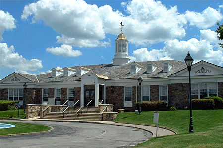
Also from that stretch of US 30/Lincoln Highway, here’s a view of the nice-looking building mentioned in yesterday’s post – the headquarters of the Municipal Authority of Westmoreland County, courtesy of that group via Susan Schmucker, whose brother’s construction company (Dill Construction) built it in 1964. It’s faced in Delaware River sandstone and topped by a metal cupola that conceals the chimney. Cost, including fountain and parking lot, was $312,500 back then. The authority moved out the end of October and it’s set to be demolished. Susan says they outgrew the facility, and traffic had increased dramatically due to retail development, but they will miss it.

PA_MAWC