Archive for the ‘signs’ Category

PBS visits Mindy and the Shoe House (& NYC)

August 19, 2008

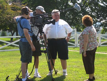
PBS producer Rick Sebak made his way to New York City last week to catch the eastern end of the Lincoln Highway. One of the stops on their way back to Pittsburgh was at the famous Haines Shoe House near York, Pa., where he met LHA board member and long-time roadside researcher Mindy Crawford, who sent these photos of her interview:


She also described the day:

Just got home from a great day with Rick, [and crewmembers] Bob and Glenn. We spent the morning at the Shoe House. I did an interview on my top 5 “must see places’ in Pennsylvania as well as some general comments about the Lincoln. Then they interviewed Carleen Farabaugh (below), the owner of the Shoe House. They got a great shot of her husband, Ron and her grandson, Austin mowing the lawn and watering flowers. Then Carleen and I did a brief “preservation segment” on the care and upkeep of the Shoe. Even my husband Rodney got involved by being a “tourist” during Carleen’s tour.

We took a break mid-day to have the most amazing Thai food. Everything was delicious but it was almost as much fun photographing everyone taking photographs of the food before we ate. When we left the crew, they were headed back to do a few more approach shots at the Shoe House.

A couple days before, Rick and crew filmed at the eastern terminus of the highway – but as the site is not marked as the start/end of the LH, they spent time with its leading champion, LHA board member Jerry Peppers, whose office overlooks Times Square. Here’s a shot from Rick of Jerry – click HERE to read all about their day in NYC.

New SCAJ; two historic roads conferences in SW

August 5, 2008

The new Society for Commercial Archeology Journal (which I design) highlights the American Southwest in anticipation of two conferences set for in September. Both events are the same weekend in Albuquerque, New Mexico, near the historic intersection of the 17th-century El Camino Real de Tierra Adentro and US Route 66.

Preserving the Historic Road 2008
September 11-14
www.historicroads.org
The 6th Preserving the Historic Road conference offers a choice of 3 tours or a field session on the 11th, sessions at the historic Kimo Theatre and Hotel Albuquerque on the 12th such as “Reality and Myth-Building on Historic Highways,” “Lodging Challenges Along Historic Highways,” and “Before the Interstate: The Perpetuation of Indigenous Roads.” The 13th will have more sessions on bridges, trail traces, and historic corridors.

Click the logo to enlarge.

Southwest Detours
September 10-13, 2008
www.sca-roadside.org
The SCA’s conference will explore automobile tourism in the southwest, with paper sessions and tours:

Thursday, Sept. 11
Bus Tour along Route 66 to Gallup, NM
The tour to Gallup along Route 66 includes Dead Man’s Curve, neon signs in Grants (“Uranium City USA”), the Continental Divide, trading posts in Gallup, and lunch at the famous 1937 El Rancho Hotel (“Home of the Movie Stars”), built by the brother of movie mogul D.W. Griffith. (includes tour book and lunch)

Friday, Sept. 12
Symposium and Paper Sessions

Saturday, Sept. 13
Bus Tour to Mountainair and Socorro, New Mexico
The old Route 60 tour will include sites spanning over three centuries. It will take us along some of the oldest alignments of Route 66 in south Albuquerque, and include lunch in Mountainair at the Pop Shafer Hotel, Restaurant and Curio Shop, with a tour of Shaffer’s Rancho Bonito. Socorro highlights will include stops at a southwestern trading post, the old plaza, and a roadside produce stand during chili season!

Here are some roadside highlights in town that I snapped early one morning:

Though centered around Route 66, you’ll meet many Lincoln Highway fans and historians, and see amazing roadside attractions, trading posts, and restaurants (the Frontier is a must-stop).

Some on-the [gravel] road snaps from Sebak

July 29, 2008

As PBS producer Rick Sebak and crew followed the Lincoln Highway to the Pacific Ocean and back, he snapped lots of photos. Here are a couple from Utah.

And here’s a video clip they made while skirting the Great Salt Desert and Dugway Proving Ground:

Learn more about their travels and the forthcoming show, A Ride Along the Lincoln Highway, on Rick’s blog. Here are some of his other nationally themed shows:

Rare pike milestone to be reinstalled in PA

July 3, 2008

D. Lowell Nissley, author of Lincoln Highway: The Road My Father Traveled, will be replanting one of the rare Lancaster Turnpike mile markers in eastern Pennsylvania this summer. The ceremony is set for Friday, August 8, 2008, subject to change. Location will be the Deerfield Corporate Center on US 30 in Frazer, at the first traffic west of Route 401. The Lincoln Highway follows much of the 200+ year old pike from Philadelphia west to Lancaster.

Lowell explains, “About 40 years ago the property where my wife grew up was sold with a very uncertain future. There was a 1795 marker (21 M to P) on their property so I rescued it and it has served a as bench outside our front door all these years. Now things at the property have stabilized enough for the replanting of this marker.”

The ceremony will commemorate the Lancaster Turnpike, the families who lived on the milestone property, and East Whiteland Township’s role in the revolutionary and transportation history of the United States.

This simple granite milestone once stood at the edge of the Lincoln Highway on the old Brackbill/ Haldeman/ Malin farm, which is now the Deerfield Corporate Center. Marking 21 miles to/from Philadelphia, it was placed along the road soon after the Lancaster to Philadelphia Turnpike opened in 1794, the first hard-surfaced road in America. There were once 64 of these stones, one per mile, but no more than a third of them remain, and not a single one between Berwyn and Downingtown.

Lincoln Highway mural in Clarks, Nebraska

May 12, 2008

John and Lenore Weiss sent this photo from a trip they took last year. They stopped in Clarks, Nebraska, and spoke with Norm Manstedt, who was having the building restored that features this Lincoln Highway mural. It is on Millard Street, the original LH through the small town. Lenore says, “New siding frames the mural. it will house a lawn and garden business with a small shop in front. John talked to this fellow for quite a while and he seems to be interested in promoting the Lincoln Highway.”

NE_ Clarks_mural

Sleepy Hollow (& puns) to be demolished

April 23, 2008

Along with the not-surprising news that the fire-damaged Sleepy Hollow Tavern will soon be torn down, the Tribune Review has a story about the tavern’s sign along the Lincoln Highway west of Ligonier. A prankster has been changing the sign, using fire-related puns like “PA Hotspot.” Even local officials are taking it in stride. Here’s a screen shot from the Trib with the latest, “Voted Hottest Wings by the Ligonier Fire Co.”

Mystery artifact: brass Lincoln Highway map

April 21, 2008

As we continue sorting things while packing to move, here’s another interesting artifact. When I have a mystery photo or postcard, I usually know the answer as to what or where is it. This time I’m not so sure. I’ve been told this oval brass map showing the Lincoln Highway could have been on a radiator or a gas pump. I know others are out there, but what is it really from?

Star Motel, Minerva Ohio, 1992

April 13, 2008

As we prepare to move, I spend lots of time sorting and packing. I’ve been looking through my photos lately and am amazed at how much things have changed along the Lincoln Highway in the 20 years since I began photographing it. Here are a couple views from February 1992 of the Star Motel in Minerva, Ohio (22071 US Route 30/E Lincoln Way). The row of rooms remains but was converted years ago into apartments. I believe the sign survives too but repainted and maybe stripped of its neon.

Snow closes parts of Lincoln Hwy in Nebraska

April 11, 2008

Leigh Henline at Fort Cody Trading Post was telling me last night about the blizzard in North Platte, Nebraska, and that parts of US 30 had to be closed. According to the North Platte Bulletin, “Traveling was also not recommended on Interstate 80 or Highway 30 west of North Platte. Travelers have reported clear roads but limited visibility. As the temperatures drop, ice has formed in some areas making traveling dangerous.” Schools also were closed Thursday and Friday due to almost 6 inches of snow.

Learn lots more about it from a stormchaser, High Plains Drifter, whose blog has maps, charts, and photos. (For future reference, the 11 posts so far about this storm can be accessed at http://www.underthemeso.com/blog/?p=469 with the last number being changed up through 479.)

Apparently, warm temps kept it from getting worse, but a NWS blizzard warning is still in effect through Friday 7 pm. According to another Bulletin story, the storm is heading to Iowa with wind gusts up to 40 mph.

Mystery Photo 6: LH Food Fuel & Liquor

March 16, 2008

Here’s a late-night photo from the Lincoln Highway in Illinois. Anyone able to identify the city?

IL_72607_0978.jpg

UPDATE: OK, it’s been answered – check the comments section. If you want to guess, don’t look at the map below yet!! The first image is from Google Street Views.

IL_GoogleStrVw.jpg

I’ve highlighted the map to show the original Lincoln Highway in Red and the rerouting in Blue, where you’ll find the business.

IL_ChicHtsMap.jpg