Just a block from the official route of the Lincoln Highway in Sacramento, Suzie Burger is a new restaurant in an old gas station (see red circle on map below). The double-canopy station at 29th and P streets was previously an Orbit station, but looks like it was probably built as a Phillips 66 in the 1960s (see the Spring 2005 Society for Commercial Archeology Journal for more on their history).
The station was later converted to Tune-up Masters, then closed and declined into a local eyesore. Locals are thrilled with the rehab, though early reviews on the food are mixed (though in fairness, three months is a normal period of adjustment). The building is not listed in any historical register so the new owners are to be commended for saving, reusing, and reviving architectural details. They have other high-end restaurants in the area. The original Suzie’s drive-in at 24th Street decades ago; Benny Ogata, son of the founders of the original, is an investor and was helping cook opening day.
The Sacramento Beereports that a basic Suzie Burger is $1.95, cheeseburger $2.95, each one served with dill pickle and carrot sticks. Grilled onions, pickled jalapenos, sauerkraut, pastrami, chili, and a fried egg range from 45 cents to $1.95 each. The menu also includes hot dogs, chili, and cheesesteaks Milkshakes and soft-serve cones also are served. The cafe red-and-white color scheme includes “Suzie” caricatures by Sacramento artist Matt Rallens. The Suzie’s website has nothing yet but the address. The map is from the LHA Driving Maps CD, available through the LH Trading Post.
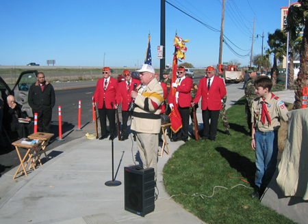
More than 50 officials, friends, and members of the Wiggin Family and Lincoln Highway Association braved chilly temperatures to dedicate a marker that honors both the Lincoln Highway and Wiggin’s Trading Post that opened there in 1924. The ceremony was held Saturday, December 8, 2007, at 15600 S. Harlan Road in Lathrop, California.
Above: At the Lathrop marker dedication, from left to right: Bob Dieterich, James Lin, Gary Kinst, Paul Gilger, Norm Root. Lloyd Johnson, Mike Kaelin, and Carolyn Lignos. The plaques read: (top) Lathrop Sunrise Rotary; (middle) America’s First Coast to Coast Road Established 1913; (bottom) 1924-1967 Site of Original Wiggin’s Trading Post Serving Travelers Along The Lincoln Highway.
Francis Wiggin’s Granddaughters, Janet and Patti, presented photos to master of ceremonies John Serpa (SEE BELOW), a member of LHA and the Lathrop Sunrise Rotary Club. Marine Corps League Detachment #109 from Modesto presented the colors, and Boy Scout Troup #425 from Lathrop led the singing of the National Anthem and the unveiling of the monument.
A Marine Corps League Certificate of Appreciation for Loyalty and Patriotism was presented by John Treantos, Commandant of #109, to Mr. Dalwinder Dhoot for flying the American flag continuously 24 hours a day, 7 days a week for 14 years at Joe’s Travel Plaza. Dhoot and family own the new Best Western Hotel at the site, and graciously allowed the Rotary to erect the marker. Mr. Dhoot then invited all guests to join the grand opening festivities for the 3-floor, 81-room hotel and provided complimentary food and beverages.Speakers included:Kristy Sayles, Mayor of Lathrop.Norm Root, President, California Chapter of the LHA (SEE BELOW).
Thanks also go to:Gabe Young, cement and engraving of stone monument.Brian Green, Signarama of Tracy.Stephen Dresser, President, Lathrop Sunrise Rotary.Dolores Delgado, Chief of Police, City of Lathrop.Charles Edwards, Boy Scout Troup #425 Leader.Richard Wiggins, Grandson of Francis Wiggins.Mary Kennedy, President, Lathrop Chamber of Commerce.And I again thank Gary Kinst for helping with info and images for this report.
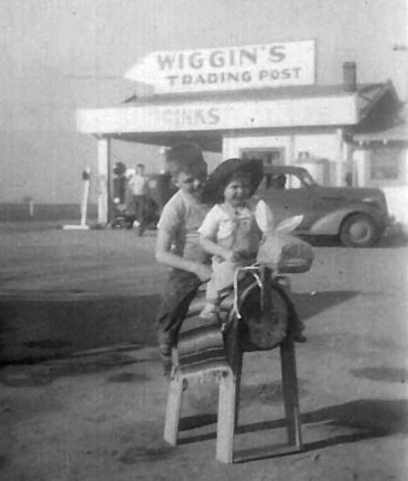
A marker was dedicated Saturday, December 8, along South Harlan Road at Thomsen Street in Lathrop, California, to commemorate the Lincoln Highway and a family business that once occupied the corner. Francis Wiggin opened Wiggin’s Trading Post along the Lincoln Highway south of Stockton in 1924. He carried Gilmore Gasoline, then in 1932, began selling “Indian Head” Gasoline, which he had patented. He also sold Indian souvenirs, learned from his days working with the Buffalo Bill Wild West Show.
Francis Wiggin’s son Francis Porter Wiggin II and his wife Ruth had seven children: Frank, Paul (b. 1934), Richard (b. 1936), Tom (b. 1940), Janet (b. 1946), Don, and Patti (b. 1955). Above, Wiggin’s grandchildren Janet and Tom ride a play horse/burro in 1949. Near the pumps might be one of their brothers.
Son Francis II joined the business around 1936, and Francis Sr. passed away in 1950. The Trading Post closed in 1967, but grandson Richard operates (but has it for sale) Wiggin’s Trading Post in Chilcoot, California at 94139 Highway 70. Another Wiggin’s Trading Post is said to be in Arizona but the location and owner are not known.
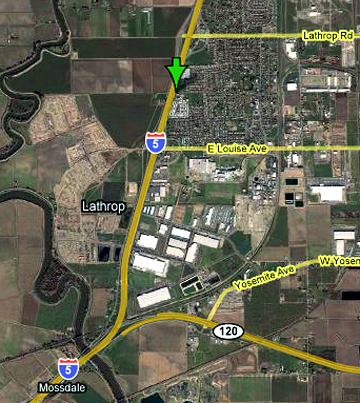
The Lincoln Highway went south from Stockton through Lathrop on what is now Harlan Road on its way to Tracy. I-5 now closely parallels the old road. Information about the ceremony will follow in a separate post. Thanks to Gary Kinst for helping with info and the image.
Three large winter storms have combined to cause what is being called by the National Weather Service “easily the strongest systems to impact the West Coast this winter season and quite possibly the last few years.” The affected area stretches from San Francisco, where 1.5 million lost power, to Fernley, Nevada, east of Reno, where a half-foot of snow caused a 30-foot break in a levee wall of the Truckee Canal, releasing water 3 feet deep into town, flooding homes and stranding 3,500. US 50 has been closed at times for avalanches, and those wanting to drive it must use tire chains. Ten feet of snow is expected in the Sierra Nevadas by Sunday.
LHA president Henry Joy takes a break for fun in the high snows of the Sierras.
As the storm moved eastward Saturday, it sent whipping winds and heavy snow into parts of Utah and Colorado, prompting authorities to close major highways — including Interstate 80 east — as the National Weather Service warned that traveling in the area “will put your life at risk.”
“Do not attempt to travel in the Sierra (region) today,” the meteorological agency said in a special weather statement….
One gust near Donner Peak measured 163 miles per hour.
The New York Timesreports that I-80 was closed overnight, then reopened Saturday but tire chains were mandatory on a 60-mile stretch. Governor Arnold Schwarzenegger was even in touch with Homeland Security Secretary Michael Chertoff.
Storms also spread across Wyoming on Thursday, causing, among other damage, the roof and walls to collapse at the Moondance Diner near Green River. The 1930s factory-built diner was moved in 2007 on a trip closely paralleling the Lincoln Highway: from near the Holland Tunnel entrance in lower Manhattan, New York City, to the small town of LeBarge, Wyoming. Read more here.
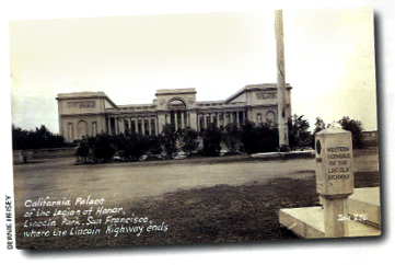
A couple interesting blog posts by John P. O’Grady recall how Lincoln Park, the western terminus of the Lincoln Highway, was once a graveyard. In fact, it still is! His first posting explains that the thousands who were buried in San Francisco’s City Cemetery were simply landscaped over a century ago so that a golf course could be built. (Yikes, don’t take any deep divots!) Over time, the rest of the area was cleared too. What happened to the thousands of wooden markers and granite monuments? They were tossed over the bluff known today as Lands Fill! (More disconcerting, the practice of discarding tombstones while leaving the bodies is apparently not at all uncommon.) The second posting explains that scavengers, under cover of night, search through the debris for treasures, and one of them, Dominic Camposanto, recently found a 1928 Lincoln Highway concrete post.
Above: The view from the Palace of the Legion of Honor, Lincoln Park, toward the Golden Gate Bridge.
Here’s the story from O’Grady’s blog:
Just recently, after an unexpected heavy rain, he discovered an original Lincoln Highway marker sticking out of the woody hillside like a phallus busted off an old Greek statue. Dom had no idea how that marker wound up in so unlikely a spot, nor did he care. He seldom takes interest in any stories attached to the articles he’s trying to unload, unless it can help make a sale. Anyway, with a prize like a Lincoln Highway marker, he didn’t need any story—all those collectors out there already had one. What they desperately lacked—and he could now supply—is the marker to go with that story. Thus Dom found an eager buyer over at the local university, a famous professor of climatology with a passion for Lincoln Highway memorabilia. The climatologist is very pleased with his purchase and has set it up in his backyard in the neighborhood around Rossi Playground. Now here’s where he could have used another story, one that might have revealed a little something about the history of this particular marker and—more importantly—something about the land upon which his own house is built. [Apparently, another graveyard.]
This could be any one of the 2,400 concrete posts placed along the Lincoln Highway in 1928, but don’t you think there’s a good chance that a LH post dumped over the hill from where the “Western Terminus” LH post once sat would be the same LH post??
Any California LH fans want to look up a climatologist living near Rossi Playground and ask to see the right side of his concrete post?
Here’s a relaxing ride on the Lincoln Highway/US 40 starting just west of Donner Summit in California.
The motorcycles (one following another) head east, top the summit, cross the Rainbow Bridge (site of the recent bear rescue), and pull over for a view of Donner Lake below. Then it’s back of the road among the pine trees and gentle curves as the highway descends the mountain. Much smoother than most videos shot form a moving vehicle. Note that the bridge is a later alignment – the original Lincoln Highway curved under the tracks of the Transcontinental Railroad, to the right of the bridge, and can still be walked.
Video by Mellowmike43, added August 2007, with music by Arlo Guthrie.
Many towns along the Lincoln Highway woke up to severe weather today, including snow and wind in the East and Midwest.
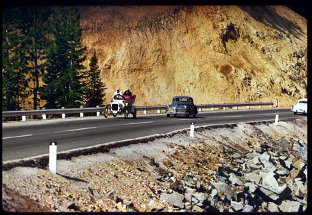
The image above shows cars struggling to climb snowy Donner Summit about 1930. This was of course where the Donner party of emigrants got caught in the early snows of early November 1846. An excellent recounting of their story that puts the reader there is The Donner Party Chronicles: A Day-by-Day Account of a Doomed Wagon Train, 1846-47 by Frank Mullen Jr. The well-researched book makes it simple and intriguing to follow their journey through the use of maps, diary excerpts, images of artifacts, modern photography, and archaeological debates.
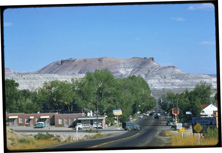
While it will only be the 20s the next few days where I am in PA, it’s will reach the 50s in Truckee, the area where many from the Donner party camped to wait out the winter. You can check my web site’s LH Weather page to see conditions at a dozen locales from coast to coast.
The Charles Weever Cushman Collection at Indiana University, Bloomington, Indiana, consists of ten cubic feet of materials, including 2,200 b/w negatives and prints. Just three of those cubic feet are slides, but what a collection — more than 14,400 color Kodachrome slides shot from 1938 to 1969. Cushman’s photos have been digitized through Indiana University’s Digital Library Program and the Indiana University Archives and are now online.
An amateur photographer, most of Cushman’s images are scenic, many are from such countries as from Lebanon, Germany, Austria, England, and Mexico. There are few roadside or industrial sites, but roads and cars do make it into many of the slides. Here are some from along the Lincoln Highway or close to it—click the links to see larger views.
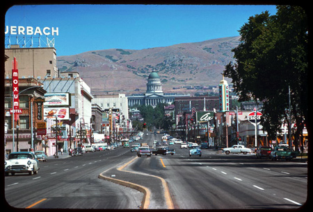
A clear day in Salt Lake City, 1958, looking north on State Street toward the capitol.
There’s lots else to see plus essays about Cushman and his collection. Photos reprinted here with the kind permission of Indiana University, Office of University Archives & Records Management, with special thanks to Curator Bradley D. Cook.
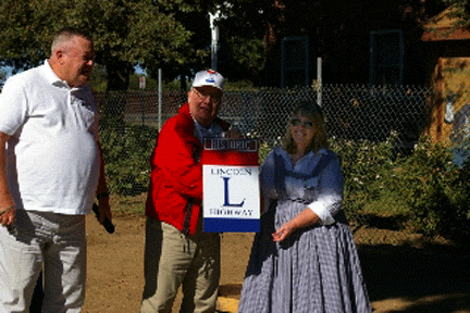
A historical marker was unveiled October 6 at the Elk Grove Hotel & Stage Stop Museum, adjacent to Elk Grove Heritage Park, 9941 East Stockton Blvd. The LHA, the Elk Grove Historical Society, and the city’s Historic Preservation Committee joined efforts, and funding was provided by the Elk Grove Auto Mall. Elk Grove Historical Society President Anita Peters and Generations Director Jeanette Lawson unveiled the historical plaque, seen below. Overlooking the ceremony from behind is Milt Webb’s Model T. See a closeup of the marker here:
LH logo signs (with a brown “historic” tag on top) were presented to the historical society and the city by CA State Director Bob Dieterich and CA Chapter President Norm Root, seen here with Elk Grove Historical Society president Anita Peters:
Visit the Elk Grove Historical Society’s Lincoln Highway page for more information and photos.
Click the map above for a full-size view of the Lincoln Highway.
Like this blog? You'll LOVE my books!Lincoln Highway Companion features detailed maps and places to eat and stay. Click the book to buy it on Amazon.
Click the Greetings book below to purchase the ultimate guide to the history and route of the Lincoln Highway!
Another fun book! The Ship Hotel: A Grand View along the Lincoln Highway recalls the greatest roadside attraction along the coast-to-coast road.
And for those who LOVE diners, click the book below to purchase our completely updated guide to the history, geography, and food of Pennsylvania's Diners!