Posts Tagged ‘highway’

LH Police Patch Collecting Causes Concern

November 22, 2007

Police patches are increasingly being collected by those interested in the imagery itself, causing concern that the patches will be used to impersonate an officer. Among the many collectable topics is the Lincoln Highway, particularly patches with a road-related graphic. The patch of the Tama, Iowa, police includes what is perhaps the most recognizable LH landmark, the town’s concrete bridge with the road’s name in its side rails. An article in the Marshalltown Times-Republican says eBay offers thousands of patches daily due to this cross-collectability: “Recently a pair of Tama Police Department patches which features the famed Lincoln Highway bridge along with an older department patch sold for just over $27 for the three. It’s likely both police patch and Lincoln Highway memorabilia collectors drove the price offering on the eBay site.” Most departments do not give patches to collectors, but instead destroy old or worn ones.

OH_Cairo patch

The police page for Cairo, Ohio makes clear in big red letters, “Cairo PD is not currently giving away or trading patches.” The patch shows the road and spells out “Lincoln Highway.” The page, which has a LH logo, also recounts the road’s history through town:

“In 1921 Lincoln Highway went through Cairo, which was known as West Cairo at the time, on the former Bucyrus Road. Lincoln Highway was eventually designated as U.S. 30. When U.S. 30 was expanded into a four lane, Cairo was bypassed approximately one half mile to the south. Although U.S. 30 has moved south, historic Lincoln Highway still runs through Cairo.”

Radio Host taking Lincoln Highway from IL to CA

November 21, 2007

CPR logo

Gianofer Fields of Chicago Public Radio is heading west, soon to pick up the Lincoln Highway. Her first stop was in Burlington, Iowa, checking out Snake Alley, aka the World’s Crookedest Street. As she says, “I haven’t even made it to the Lincoln Highway and I’m already having a great time. With about 2000 miles to go on this trip, I’d better pace myself.” Read the first day’s journal (Monday, Nov. 26) or listen to it at the Chicago Public Radio site.

PA's Westmoreland County plots future of US 30

November 21, 2007

The two developments mentioned yesterday are just a small part of Route 30’s spiraling growth east of Pittsburgh. Concern for the corridor led the Smart Growth Partnership of Westmoreland County to host a 5-day design charrette atPA Growth logo 
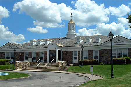
the University of Pittsburgh’s Greensburg campus (its home base). The focus was the future of U.S. 30/the Lincoln Highway—how to specifically preserve the rural landscape, revitalize towns, and enjoy the benefits of growth while avoiding clogged roadways, vanishing open spaces, and soaring home prices.

A 4-year study started in 2005 covers 40 miles and 12 municipalities from Pittsburgh’s eastern suburbs to the Laurel Highlands, known to Lincoln Highway travelers for the steep winding road on the west side of Laurel Mountain. A master plan being developed will present a prototype for safe, efficient, attractive, and connecting land use. The finished plan is expected in April 2008, followed by a year of implementation. According to Smart Growth, the project is unique in that a non-profit entity is taking a proactive, collaborative approach to help shape communities.

PA_Greensburg rural

Above: The Lincoln Highway east of Greensburg, Pennsylvania. With 4-lane US 30 to the right, and houses rising on farmland to the left, how long can this rural roadscape survive?

An article in the Pittsburgh Post-Gazette summarized the concepts developed by the group with help from a team of design professionals, engineers, architects, urban planners and landscape architects:

• Mixed use development with the highest density centered on Route 30.

• Public open spaces providing gathering places throughout the site.

• A gateway at the intersection of Route 30 and Route 981 serving as an “arrival point” to Latrobe and the Laurel Highlands.

• Retaining the Route 30 corridor as a regional connection with parallel roads providing local “circulation.”

• Greenways defining the development areas as well as connecting the rural context of the development.

Visit www.route30plan.com to see the plan, photos, and more information.

Also from that stretch of US 30/Lincoln Highway, here’s a view of the nice-looking building mentioned in yesterday’s post – the headquarters of the Municipal Authority of Westmoreland County, courtesy of that group via Susan Schmucker, whose brother’s construction company (Dill Construction) built it in 1964. It’s faced in Delaware River sandstone and topped by a metal cupola that conceals the chimney. Cost, including fountain and parking lot, was $312,500 back then. The authority moved out the end of October and it’s set to be demolished. Susan says they outgrew the facility, and traffic had increased dramatically due to retail development, but they will miss it.

PA_MAWC

Roadhouse-turned-restaurant closes in W PA

November 20, 2007

Chesterfields Restaurant, a popular dining choice in North Huntingdon Twp., Pennsylvania, closed recently to make way for a Walgreens drug store and a Starbucks. The Lincoln Highway landmark just west of Irwin (now across from Norwin Shopping Center) opened as the El Dorado in 1934, then for years was the Ben Gross Supper Club, famed for its dinner theater. It had been Chesterfields since 1986, and was one of the last of the region’s legendary dinner spots. According to The Daily News [McKeesport, Oct. 23], with the current owner’s husband passed on and their two sons not interested in a labor-intensive business, they sold to Walnut Capital brokerage firm for $1.5 million. The restaurant was host to many local banquets, celebrations, and Rotary meetings, and until recently had 87 employees. Also likely to be demolished is the adjacent Kirk Haight Auto Sales, best known in years past for having a car atop a pole. See a short video of Chesterfields final day at WPXI.

PA_El Dorado
1934: Signs advertised spaghetti, steak, chicken, beer, and dancing to an orchestra.

PA_Chesterfields
2007: You can still see the roadhouse and to its left, a one-story building with gable windows.

According to a Tribune-Review article, the 3.6 acre plan needed a variance or it would not have been allowed under the shopping center code, so 58 parking spaces will serve where 87 would otherwise be required for that size development. Also, the township asked for an electronic community bulletin board along the Lincoln Highway across from the intersection with Lincoln Way (a road deceptively named in the 1920s to divert LH traffic through the Mon Valley). An Eckerd Pharmacy already sits across the road at that intersection.

According to Walnut Capital’s site, the developer also bought and is demolishing the 1964 Colonial Revival headquarters of the Municipal Authority of Westmoreland County on the Lincoln Highway to the east in Hempfield (west of Greensburg) for a Walgreens and other retail. (That 16.1 acre site went for $6 million.) In a nod to the road, it will be known as Lincoln Place. Click here for images of that development.

Western Wyoming LH Corridor Threatened

November 18, 2007

Our friend RoadDog alerts us to a possible threat to the Lincoln Highway in western Wyoming. An article in the Casper Star-Tribune says there’s a good chance the undrivable Lincoln Highway remnant from Green River east to Rock Springs could be revamped into a connector road. Though the two cities are just 12 miles apart, I-80 is the only paved road connecting them, forcing commuters and other locals to compete with a rising tide of trucks brought on by the region’s oil and gas boom.

WY_Green River I-80

According to the article, “Two of the three proposed routes would begin at Green River’s east I-80 interchange and then follow the remnants of the old Lincoln Highway—which used to run between the two cities—north of I-80. A third route would start on the city’s south side and run south of the interstate, hooking up with U.S. Highway 191…. [U]nofficial cost projections to build an approximately 12-mile-long road have been estimated at about $2 million per mile, or around $24 million total. Officials expect the project to take a decade or longer to complete.”

Most dismaying for those concerned about preserving the LH’s roadscape, local leaders hope the new road will bring housing, business, and industry. Green River officials especially say the city has been hemmed in by Castle Rock and I-80 to the north, and steep undevelopable land to the south.

UPDATE 12/31/07: “Locals will help choose route” in the Caspar Star-Tribune.

LH Marker Dedicated in Elk Grove, California

November 14, 2007

A historical marker was unveiled October 6 at the Elk Grove Hotel & Stage Stop Museum, adjacent to Elk Grove Heritage Park, 9941 East Stockton Blvd. The LHA, the Elk Grove Historical Society, and the city’s Historic Preservation Committee joined efforts, and funding was provided by the Elk Grove Auto Mall. Elk Grove Historical Society President Anita Peters and Generations Director Jeanette Lawson unveiled the historical plaque, seen below. Overlooking the ceremony from behind is Milt Webb’s Model T. See a closeup of the marker here:

Elk Grove marker 1

LH logo signs (with a brown “historic” tag on top) were presented to the historical society and the city by CA State Director Bob Dieterich and CA Chapter President Norm Root, seen here with Elk Grove Historical Society president Anita Peters:Elk Grove marker 2

Visit the Elk Grove Historical Society’s Lincoln Highway page for more information and photos.

Library, Lodging, and Restaurant Links Updated

November 13, 2007

I’ve been adding to the links column to the right, listing libraries to check your email or learn about local history; non-chain motels; and restaurants with local flavor. I have lots more to add, though admittedly very few ideas for lodging or restaurants along the Lincoln Highway in New Jersey. Anyone have recommendations?

OH_Lisbon cabin

Above: Tourist cabin along the Lincoln Highway, 3 miles east of Lisbon, Ohio, now an apartment.

Vintage Photos Capture Lives on the Road

November 12, 2007

Randy Garbin recently reported on his Roadside Online about an amazing collection of roadtrip photos titled Lighting Out for the Territory. They’re on Square America, named for the common shape of old candid photos, and “dedicated to preserving and displaying vintage snapshots from the first 3/4s of the 20th Century” Collector/curator Nicholas Osborn says, “For the last eight years or so I’ve spent countless hours digging through boxes of old snapshots at flea markets (mostly here in Chicago and in NYC) and too much money buying photos on eBay. The site is my attempt to create some kind of organizational framework, however idiosyncratic, for the sprawling mess my collecting has created.” Here are two from “Lighting Out,” with his permission:

SqAm-Iowa

SqAm-Get
Above: Looking west on the Lincoln Highway east of Gettysburg, Pennsylvania, early 1970s.

And here’s his description:
“From the late 1950s through the early 1970s, Martin C. Johnson took a number of road trips criss-crossing the country from his home in Suburban Chicago to both coasts and all points in between. For each trip he put together a slide show to document his travels. Judging from these shows, he (and his wife who must be responsible for at least some of the photographs) was far more interested in the road itself than wherever his final destination might have been. For every photograph of Mount Rushmore or The Grand Canyon there were three or four shots of the empty (or not so empty) road taken through the windshield of the car. For every shot of friends and relatives visited, there were two of the motels he stayed in on the way. In doing so Johnson has left behind an invaluable record of the golden age of auto travel – an era when the new interstate highway system had opened up the country but before the development it brought had homogenized it.”

Osborn’s site is filled with countless images from about 1910-1970, grouped into categories. You might also enjoy shots from The Road:

SqAm-gas2

The images are both amazing and invaluable to roadside fans, but also a reminder that the past was not nearly as tidy as we like to remember, or recreate, it.

Postcard Look at Gettysburg Garage

November 11, 2007

Jeff Durbin of Gaithersburg, Maryland, also visited Gettysburg, Pennsylvania recently, and sent this postcard of an auto garage on Chambersburg Street. It’s the same one seen in my photo of the Ragged Edge Coffeehouse (you can see the house too that’s now the coffee shop). Looks like they sold Texaco gas, and the caption on back told early motorists what other amenities awaited them:

PA Get garage

The New Eberhart Garage is located on The Lincoln Highway (Chambersburg and Washington Streets). Opposite the New Eagle Hotel and is the finest Garage in southern Pennsylvania having a storage capacity of 150 cars, unsurpassed service, with no waiting to be served. Ladies Rest Room on main floor, free air throughout the building and to the front curb. Absolutely fire proof, constructed of brick, concrete steel and terra cotta. Competent Mechanics. Day and Night Service. Storage, Supplies and Repairs.

Indiana Curriculum to Spotlight Lincoln Highway

November 8, 2007

A Lincoln Highway curriculum unit is being prepared by the LHA Indiana chapter. “Indiana’s Historic Lincoln Highway” will offer a complete 2-week course for grades 3 and 4, formatted to Indiana State Standards. Project Leader Joyce Chambers says a team has been working for a year and a half gathering information and creating hands-on activities for topics such as maps, math, art, music, language, and science. Field research is wrapping up for this year as colder weather approaches.

IN_UM concrete
Above: Pouring the last concrete between Osceola and Mishawaka, Indiana. (Univ of Michigan, Special Collections Library, lhc2276)

The kit will likely contain a Teacher’s Guide, Student Booklet, DVD history of the road, possibly some model race cars (a nod to Carl Fisher’s connection to the Indy Speedway), a LH BINGO Game, and images of the road in Indiana, all in a sturdy tote bag. Sections may include Overview, Construction, Bridges, Tollhouses & Mile Markers, Travelers, Accommodations, Workers along the Road, Fun Sheets, Timeline, Lincoln Highway Sites, Glossary, Bibliography, Evaluation, and information on the LHA. The South Bend Community School Corporation’s Print Shop will donate the printing.

IN_UM_Ideal Sec 
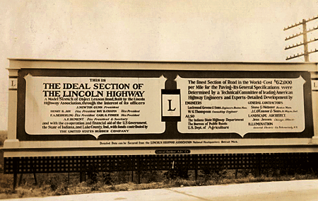
Above: A billboard on the Lincoln Highway’s famous Ideal Section in western indiana, 1927. (Univ of Michigan, Special Collections Library, lhc2793)

Three or four schools will test a pilot version for the 2008-’09 school year, then it will be evaluated and revised for release in 2009-’10 to public libraries and schools along the LH. Further suggestions will be incorporated into a final version available to all Indiana schools, including homeschoolers and private/parochial. It will be available through “check out” at the Center for History Education Department, where other such kits are stored for teachers. A similar highway-themed curriculum is Traveling the National Road Classroom Activity Program.

A kit and PowerPoint show will be presented at the LHA’s 2008 conference, and a presentation at the ’09 event will include feedback from the test year. It sounds like a solid plan, and a model program for other LH states.

IN_UM_curve
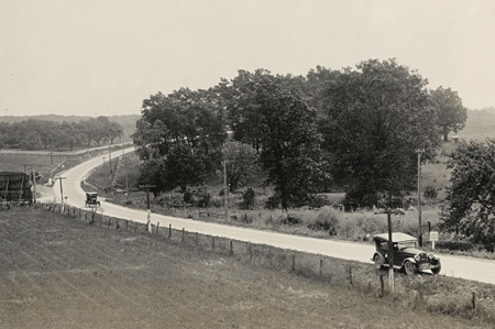
Above: The LHA Packard touring through Indiana, 1925. (Univ of Michigan, Special Collections Library, lhc2313)

For more information, or to make suggestions about content, contact Joyce Chambers at joycechambers47@aol.com (574) 272-5374.