Archive for November, 2007

LH Marker Dedicated in Elk Grove, California

November 14, 2007

A historical marker was unveiled October 6 at the Elk Grove Hotel & Stage Stop Museum, adjacent to Elk Grove Heritage Park, 9941 East Stockton Blvd. The LHA, the Elk Grove Historical Society, and the city’s Historic Preservation Committee joined efforts, and funding was provided by the Elk Grove Auto Mall. Elk Grove Historical Society President Anita Peters and Generations Director Jeanette Lawson unveiled the historical plaque, seen below. Overlooking the ceremony from behind is Milt Webb’s Model T. See a closeup of the marker here:

Elk Grove marker 1

LH logo signs (with a brown “historic” tag on top) were presented to the historical society and the city by CA State Director Bob Dieterich and CA Chapter President Norm Root, seen here with Elk Grove Historical Society president Anita Peters:Elk Grove marker 2

Visit the Elk Grove Historical Society’s Lincoln Highway page for more information and photos.

Library, Lodging, and Restaurant Links Updated

November 13, 2007

I’ve been adding to the links column to the right, listing libraries to check your email or learn about local history; non-chain motels; and restaurants with local flavor. I have lots more to add, though admittedly very few ideas for lodging or restaurants along the Lincoln Highway in New Jersey. Anyone have recommendations?

OH_Lisbon cabin

Above: Tourist cabin along the Lincoln Highway, 3 miles east of Lisbon, Ohio, now an apartment.

Vintage Photos Capture Lives on the Road

November 12, 2007

Randy Garbin recently reported on his Roadside Online about an amazing collection of roadtrip photos titled Lighting Out for the Territory. They’re on Square America, named for the common shape of old candid photos, and “dedicated to preserving and displaying vintage snapshots from the first 3/4s of the 20th Century” Collector/curator Nicholas Osborn says, “For the last eight years or so I’ve spent countless hours digging through boxes of old snapshots at flea markets (mostly here in Chicago and in NYC) and too much money buying photos on eBay. The site is my attempt to create some kind of organizational framework, however idiosyncratic, for the sprawling mess my collecting has created.” Here are two from “Lighting Out,” with his permission:

SqAm-Iowa

SqAm-Get
Above: Looking west on the Lincoln Highway east of Gettysburg, Pennsylvania, early 1970s.

And here’s his description:
“From the late 1950s through the early 1970s, Martin C. Johnson took a number of road trips criss-crossing the country from his home in Suburban Chicago to both coasts and all points in between. For each trip he put together a slide show to document his travels. Judging from these shows, he (and his wife who must be responsible for at least some of the photographs) was far more interested in the road itself than wherever his final destination might have been. For every photograph of Mount Rushmore or The Grand Canyon there were three or four shots of the empty (or not so empty) road taken through the windshield of the car. For every shot of friends and relatives visited, there were two of the motels he stayed in on the way. In doing so Johnson has left behind an invaluable record of the golden age of auto travel – an era when the new interstate highway system had opened up the country but before the development it brought had homogenized it.”

Osborn’s site is filled with countless images from about 1910-1970, grouped into categories. You might also enjoy shots from The Road:

SqAm-gas2

The images are both amazing and invaluable to roadside fans, but also a reminder that the past was not nearly as tidy as we like to remember, or recreate, it.

More on the Donner Summit Bridge Bear Rescue

November 12, 2007

One of the most popular posts here has been the October 31 story about a bear stuck overnight on the Rainbow Bridge at Donner Summit, and how volunteers rescued it the next day. The bridge is on a rerouting of the Lincoln Highway—the original path can still be seen snaking through the “subway” beneath the old railroad tracks, but that was bypassed in 1926 by the road that includes this bridge. Truckee Animal Control Officer Dan Olsen has graciously loaned more of his on-the-spot photos that show the dedication and determination of volunteers who rigged a net, tranquilized the bear, and lowered it to safety. Thanks again Dan!CA Olsen bear1

Click on these for a larger image:

CA Olsen bear2
CA Olsen bear3 CA Olsen bear4CA Olsen bear5 CA Olsen bear6 CA Olsen bear7

LH Roadside Attractions among Priceless Picks

November 11, 2007

I was asked by MasterCard to be part of their online Priceless Picks campaign. There are lots of interesting places in people’s picks; I chose roadside attractions and of course included some Lincoln Highway sites. Here’s a link to mine, where you’ll find LH mentions of the fun Shoe House in Hallam, Pennsylvania, and souvenir-filled Fort Cody Trading Post in Nebraska. There’s also a photo to click of Peppi’s Diner on the LH in Wilkinsburg, Pennsylvania. Other picks include Wigwam Village motel on Route 66 in Holbrook, Arizona; the crazy Mexican restaurant Casa Bonita in Denver; dinos battling Civil War soldiers at Dinosaur Kingdom in Natural Bridge, Virginia; and the 1950s-era Eddie’s Grill in little Geneva-on-the-Lake, Ohio.

Priceless Picks

Postcard Look at Gettysburg Garage

November 11, 2007

Jeff Durbin of Gaithersburg, Maryland, also visited Gettysburg, Pennsylvania recently, and sent this postcard of an auto garage on Chambersburg Street. It’s the same one seen in my photo of the Ragged Edge Coffeehouse (you can see the house too that’s now the coffee shop). Looks like they sold Texaco gas, and the caption on back told early motorists what other amenities awaited them:

PA Get garage

The New Eberhart Garage is located on The Lincoln Highway (Chambersburg and Washington Streets). Opposite the New Eagle Hotel and is the finest Garage in southern Pennsylvania having a storage capacity of 150 cars, unsurpassed service, with no waiting to be served. Ladies Rest Room on main floor, free air throughout the building and to the front curb. Absolutely fire proof, constructed of brick, concrete steel and terra cotta. Competent Mechanics. Day and Night Service. Storage, Supplies and Repairs.

Kearney Covered Wagon Follow-Up

November 10, 2007

A few days after my story ran on the Covered Wagon, an article perhaps inspired by this blog ran on the front page of the Kearney Hub. It even featured my 1950s postcard of the place (though initial editions like the one below erroneously credited the image). Writer Todd Gottula talked to the owner and contractor, who is adding a second floor to convert the building into offices with log siding.

Kearney Hub Front Page

Gottula pinned down some dates: the Covered Wagon was sold to Boyd McClara in 1939, then Nick and Rose Ponticello purchased it in 1963. Nick auctioned many of the souvenirs in 2001 before selling the property to Hayes.

Jamie Hayes, who purchased the property four years ago from Nick Ponticello, says he wants to return it as close as possible to its original look. Since work started around the end of September, motorists keep stopping to talk with contractor Ray White and sons. Hayes says the amount of interest is unbelievable, with most making sure the site is being preserved, not destroyed.

NE_BH_CovWag
A whimsical postcard view from a Covered Wagon attraction, courtesy Bernie Heisey.

Gottula reported in a sidebar story that the site inspired local musician Mike Nicolen to write a song about the Covered Wagon after meeting the Ponticellos in 1999. His thoughts, also on his website, mirror that of many old-time LH fans: “I think instead of building a $50 million archway across the interstate to commemorate westward expansion, they should have sent someone with a tape recorder and camera out to see Nick and Rose.” Nicolen’s site explains further, “Nick and Rose held on to the place and kept it open into their 80’s when health problems finally forced them into a nursing home…. Nick told me once that the Archway people wanted to buy him out and move his beloved Covered Wagon out to the Interstate. He said ‘Why don’t you pick up your Arch and move it out here? I’ve been here a lot longer than you’ve been out there!'”

Nicolen’s song likewise tells how I-80 and the Archway draws traffic from the 2-lane. Click Here to listen to Covered Wagon courtesy of the Kearney Hub or go to Mike’s site and scroll down to the last song, He tells the story from Nick’s point of view. with lines like:

Parked along the highway of our dreams
Facing westward, time moves onward here in the land of opportunity

Now they travel down I-80 doing 85 or more
They gas up at the interchange they’ll never see my store

Millionaire's Marker Mystery west of Chicago

November 9, 2007

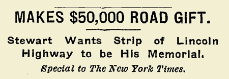
A New York Times story I found from December 1913 reported that 88-year-old John Stewart of Elburn, Illinois, was giving away huge sums of money, including $50,000 to improve the Lincoln Highway. He asked that markers be set at each end of the road section that his donation improved. Were those markers ever placed?
Stewart NYT

Elburn is a small town some 40 miles west of Chicago, and just west of Geneva, nestled between the original Lincoln Highway (still called that but better known as Keslinger Road) and IL 38. A 1921 shortcut connected Keslinger Road to IL 38 via Elburn’s Main Street, and a few years later, Keslinger was bypassed entirely. Though rural, suburbia continues to fan out from Chicago; check out this planning map to see how quickly the landscape is changing.

Stewart was in Europe at the time, but the article was datelined Chicago, so it began as a local story. No wonder—he also gave $100,000 to granddaughter Esther Richards as a wedding present, and to all his grandchildren, he bequeathed his estate valued at $750,000. My favorite inflation calculator says that alone is the equivalent of $15.1 million today!

Stewart 3

I checked with some town planners and officials, but no one has heard of the markers. What they didn’t say was that the local elementary schoool is named for John Stewart! Or that the town has preserved his mansion!

Stewart 6

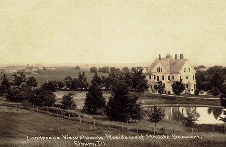
The Great Lakes Leadership Campus on IL 47 occupies the Stewart estate. Director Annette Sheehan (who graciously OK’d use of the photos here) says, “To my knowledge, there are no markers bearing his name on Route 38 through Elburn. I don’t know if there ever were—I’ve never heard about any such markers.” The GLLC website says the 15-bedroom Victorian mansion was built in 1897 for John, Martha, and their 5 children. Its lavish appointments like hand-cut lead glass windows, tiled fireplaces, inlaid wood flooring, wooden ceilings, and in all a hundred types of wood led to the home being featured on a 1908 postage stamp. John Stewart served three terms in the state legislature, and interestingly, funded the paving of Elburn’s Main Street.
Stewart 4

I asked Kathleen Dow at the LHA archives at the Special Collections Library, University of Michigan, if Stewart shows up in their holdings. She found nothing in LHA minutes, correspondence (particularly checking the pledges), or brochures of major expenditures and donors. Could it be that, since the LHA never reached its goal of $10 million, pledges didn’t have to be paid? Kathleen replied, “From what I’ve seen in the LHA correspondence, some pledges were contingent on the pledge goal being reached before any checks were cut (many of the donors, or would-be donors, were businessmen, of course). So, yes, I think a number of pledges were never kept. I think there were also some quibbles about businesses, both small and large, pledging 1% of a year’s profit (I believe that’s what was initially solicited).”

So was the $50,000 ever donated? If so, were markers erected in Elburn or elsewhere? Or did the LHA not get the funds because they never reached their $10 million goal?

Indiana Curriculum to Spotlight Lincoln Highway

November 8, 2007

A Lincoln Highway curriculum unit is being prepared by the LHA Indiana chapter. “Indiana’s Historic Lincoln Highway” will offer a complete 2-week course for grades 3 and 4, formatted to Indiana State Standards. Project Leader Joyce Chambers says a team has been working for a year and a half gathering information and creating hands-on activities for topics such as maps, math, art, music, language, and science. Field research is wrapping up for this year as colder weather approaches.

IN_UM concrete
Above: Pouring the last concrete between Osceola and Mishawaka, Indiana. (Univ of Michigan, Special Collections Library, lhc2276)

The kit will likely contain a Teacher’s Guide, Student Booklet, DVD history of the road, possibly some model race cars (a nod to Carl Fisher’s connection to the Indy Speedway), a LH BINGO Game, and images of the road in Indiana, all in a sturdy tote bag. Sections may include Overview, Construction, Bridges, Tollhouses & Mile Markers, Travelers, Accommodations, Workers along the Road, Fun Sheets, Timeline, Lincoln Highway Sites, Glossary, Bibliography, Evaluation, and information on the LHA. The South Bend Community School Corporation’s Print Shop will donate the printing.

IN_UM_Ideal Sec 
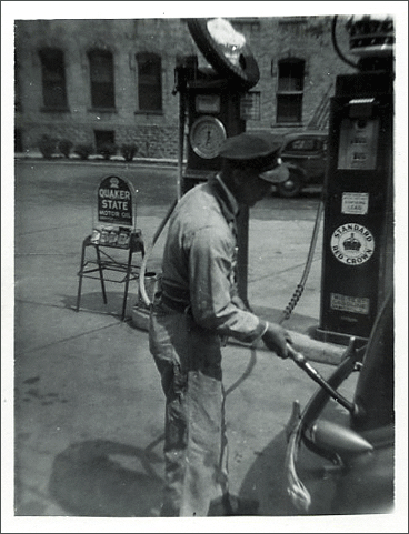
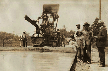
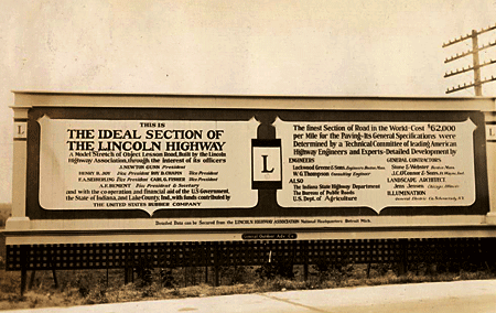
Above: A billboard on the Lincoln Highway’s famous Ideal Section in western indiana, 1927. (Univ of Michigan, Special Collections Library, lhc2793)

Three or four schools will test a pilot version for the 2008-’09 school year, then it will be evaluated and revised for release in 2009-’10 to public libraries and schools along the LH. Further suggestions will be incorporated into a final version available to all Indiana schools, including homeschoolers and private/parochial. It will be available through “check out” at the Center for History Education Department, where other such kits are stored for teachers. A similar highway-themed curriculum is Traveling the National Road Classroom Activity Program.

A kit and PowerPoint show will be presented at the LHA’s 2008 conference, and a presentation at the ’09 event will include feedback from the test year. It sounds like a solid plan, and a model program for other LH states.

IN_UM_curve
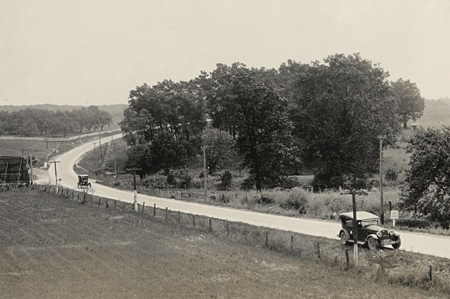
Above: The LHA Packard touring through Indiana, 1925. (Univ of Michigan, Special Collections Library, lhc2313)

For more information, or to make suggestions about content, contact Joyce Chambers at joycechambers47@aol.com (574) 272-5374.

Click the Lincoln Highway Map

November 7, 2007

For those not familiar with the route of the Lincoln Highway, I now have a map available based on the one in my Greetings book. Click the thumbnail below or the really tiny one to the right and you’ll get a US map up to 19 inches wide, just like this one:

Butko Greetings LH map - Med

The first generation represents the “Proclamation Route” of 1913. Towns like Trenton, NJ; Marion, OH; and Ogden, UT were quickly removed (though Ogden would later be put back on).

You’ll also see the Colorado Loop, which the LHA soon regretted but nonetheless approved of for two years. Note also that there were two ways around Lake Tahoe in eastern California. West of Sacramento, the 1928 rerouting is being debated of late as to whether the change was officially endorsed by the LHA board. It’s included because that’s where the LHA’s concrete posts went in 1928.

The first tally of the Lincoln Highway’s length was 3,389 miles (including Camden and Marion but not Ogden), though it would always be in flux due to bypasses and realignments. More than a decade later, the now more-famous US Route 66 would run 2,448 miles from Chicago to Los Angeles (though it likewise would vary in length).