The crash of United Flight 93 on September 11 changed Somerset County, Pennsylvania, in many ways. The curious instantly began streaming to the site just off the Lincoln Highway/US 30, and entrepreneurs began servicing the visitors. The western of the two access roads from Route 30 crosses an original alignment of the Lincoln. A temporary memorial continues to draw visitors, but the National Park Service has a larger memorial planned.
An article in the Daily American reports that local coal trucks are often involved in accidents, and when the Flight 93 National Memorial opens after 2011, US 30 is expected to carry as many as 400,000 more travelers a year. The Flight 93 National Memorial Corridor Study identified a preferred route to guide visitors to the memorial, which ultimately has to travel Route 30. At two public meetings, locals said the road should be wider, better maintained, and have fewer coal trucks. A traffic engineer said the accidents appear to be “relatively isolated incidents.”
The corridor study concludes that the significant horizontal and vertical curvature of the roadway and the corresponding restrictions on sight distance and the heavy volume of truck traffic make traffic safety a paramount concern. This is especially true for a two-thirds-mile stretch east of the intersection with Old Lincoln Highway, the study reported.
The study counts some 400 vehicles traveling to the site daily, and 900 on weekends. Once the new memorial opens, 400,000 are expected annually before tapering to 230,000.
The entrance will be from a third, more easterly location, where Old Lincoln Highway meets Route 30. The intersection would be reconfigured, probably affecting the remaining buildings from the former Emerald Park tourist camp and tavern. For now, PennDOT is planning improvements east of Stoystown including replacing three bridges, and adding turning lanes at the intersection with Route 403.
Locals responded to the flow of cars by creating yard sales, commemorative objects, and businesses to serve visitors. The photo above shows the Long Vu Motel just west of Reels Corners with a new name and sign promoting it’s connection to 9-11. Adele’s Diner across the road was in the news recently for similarly renaming to the Heritage Highway Restaurant, a nod to the range of history along the Lincoln Highway.
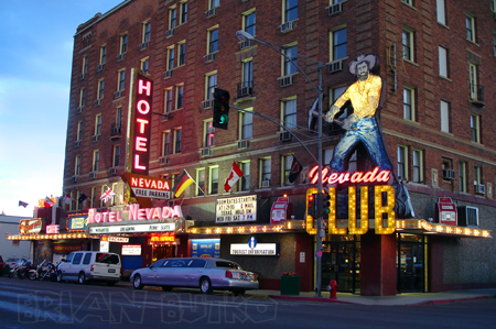
Ely’s Hotel Nevada offers 63 rooms, a casino, and a 24-hour restaurant. When the 6-story hotel opened in 1929, it was the tallest building in the state. Rooms today start at just $35.
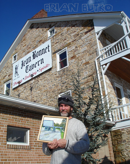
Snow was predicted today but it was clear and bright at I drove the Lincoln Highway to the Jean Bonnet Tavern a few miles west of Bedford, Pa. The 1762 inn is at a fork of two old military paths: Forbes Road (LH/US 30) and Glades Road (PA 31). A 1928 concrete post at the intersection points out how to stay on the Lincoln.
I met Kyle Weaver, editor of my forthcoming Lincoln Highway Companion book. Also spent time with Kevin Kutz, the Lincoln Highway’s leading artist and author of a beautiful book of LH imagery. His artwork of the LH and other roadside attractions can be found in many regional shops. Here he holds his latest, a painting of Haar’s Drive-In Theater in Dillsburg, Pa.
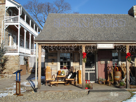
Lunch at the inn was in the bottom-floor dining room. A huge, open fireplace kept the dimly lit room toasty. Afterward we visited the gift shop in a great-looking reconstructed log cabin just a few feet away. They stock lots of locally made products. and many regional books from Stackpole, including my The Lincoln Highway: Pennsylvania Traveler’s Guide. I picked up a jug of local syrup.
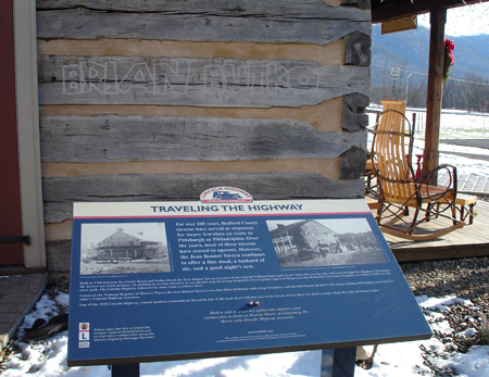
Between the two buildings is a LH interpretive panel courtesy of the LH Heritage Corridor. Next time you’re driving the Lincoln Highway in Pennsylvania, plan to stop by Jean Bonnet for lunch, browsing, and LH history.
Just a block from the official route of the Lincoln Highway in Sacramento, Suzie Burger is a new restaurant in an old gas station (see red circle on map below). The double-canopy station at 29th and P streets was previously an Orbit station, but looks like it was probably built as a Phillips 66 in the 1960s (see the Spring 2005 Society for Commercial Archeology Journal for more on their history).
The station was later converted to Tune-up Masters, then closed and declined into a local eyesore. Locals are thrilled with the rehab, though early reviews on the food are mixed (though in fairness, three months is a normal period of adjustment). The building is not listed in any historical register so the new owners are to be commended for saving, reusing, and reviving architectural details. They have other high-end restaurants in the area. The original Suzie’s drive-in at 24th Street decades ago; Benny Ogata, son of the founders of the original, is an investor and was helping cook opening day.
The Sacramento Beereports that a basic Suzie Burger is $1.95, cheeseburger $2.95, each one served with dill pickle and carrot sticks. Grilled onions, pickled jalapenos, sauerkraut, pastrami, chili, and a fried egg range from 45 cents to $1.95 each. The menu also includes hot dogs, chili, and cheesesteaks Milkshakes and soft-serve cones also are served. The cafe red-and-white color scheme includes “Suzie” caricatures by Sacramento artist Matt Rallens. The Suzie’s website has nothing yet but the address. The map is from the LHA Driving Maps CD, available through the LH Trading Post.
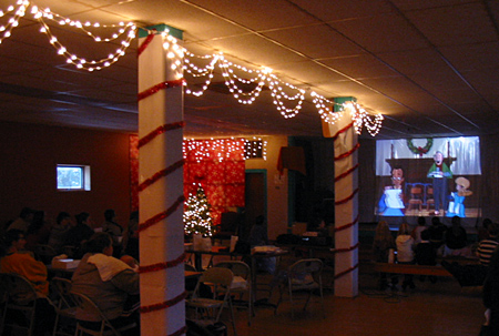
Clarence Iowa has found that the Lincoln Highway is a route to getting things done. The Clarence Lincoln Highway Committee was founded in 1997 by local businesses and citizens to organize a fun summer fund-raiser for community projects. Their efforts have expanded to many other projects, and this year, the group took over the town’s Christmas festival.
Bad weather delayed the fun one day to December 2, but it was well attended. Businesses contributed generously, such as Kelly Tree Farm, which gave evergreens to line the streets, and individuals baked lots of desserts for a Cookie Walk, with all proceeds benefiting the 2009 Clarence Sesquicentennial Community Projects. The Tipton Conservative covered the event in advance.
A portion of the Festival of Trees display from Christmas in Clarence.
The summer event, the Clarence Lincoln Highway Festival, is still their major effort, which we’ll report on separately. Jen VanOort, editor/designer of the Clarence Community Newsletter and webmaster for www.lincolnhighwayfestival.com, says, “The festival went along at a quiet but profitable pace for many years until two years ago when new leadership was established and the festival really blossomed into an exciting, fun, well-attended event for the entire area, and was even mentioned in the Chicago Tribune.”
Clarence children enjoying a movie before Santa arrives.
Other plans for the future include a farmers’ market, downtown streetscaping, façade improvements, and concerts and ice cream socials in the downtown park. Jen says, “Keep your eye on Clarence! We have big plans! The funny thing is, our leader, Jamie Wilhau is not native to Clarence or even Iowa, but she feels so passionately about this town, its history, and its potential that she is infectious! Together, we dream up a lot of ideas!”
Jen adds that Clarence is special to highway fans too. “We have the distinction of being one of the only communities left in Iowa with the Lincoln Highway as our main street! No bypass yet … although they are threatening that in the future”
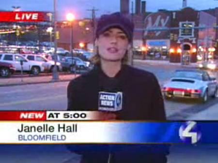
Don Allen Auto City, a well-known car dealership on Pittsburgh’s East End, is set to be replaced by a $230 million development. The c. 1920 showoom and related areas cover seven acres where Baum Boulevard intersects Liberty Avenue, and at the confluence of three communities: Shadyside, Bloomfield and East Liberty. All buildings will be demolished and over the next four years, the site will fill with townhouses, condominiums, a 9-story hotel, 1,200 parking spaces, and 700,000 square feet of office and related space. A triangular park bordered by Liberty, Baum and South Aiken Avenue will also be built. Numerous publications and sites are covering the story including Hotels, Pittsburgh Post-Gazette, and Pittsburgh Tribune-Review.
Don Allen opened 52 years ago and has been owned by the Voelker family for 50 years. The building long had a 1960s metallic facade, but it was removed in recent years, exposing the brick underneath. A mural from that period remains in the parts department, its fate unknown. The business stretches a few blocks along Baum Boulevard, once the city’s Automobile Row. It was a main road into Pittsburgh’s wealthy eastern suburbs, and so became a leading retail, repair, and manufacturing center for bicycles, and then for cars by the 1910s. Scattered remnants survive, including a former Ford assembly plant a couple block west, a 1933 Modernist Chrysler showroom designed by Albert Kahn a few blocks east, and a showroom turned drug store across from that. A few blocks farther eastward is a marker for the first drive-in filling station, which is more correctly the first architect designed drive-in station, built by Gulf in 1913
This video report below includes a woman who says “they need something that’s more affordable…. It’s just outrageous trying to find a place that people can afford.” Another questions whether more housing and hotels are needed. Click on the image to open the video’s web page:
Inventory liquidation is ongoing, and site preparation should start this summer, pending city approval and funding; according to the Post-Gazette, “The project partners acknowledge that they hope to secure public financing to assist with the project, although they were not willing today to specify what type or how much.”
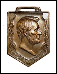
I’ve been working with Lincoln Highway National Museum and Archives director Craig Harmon on a discovery of his: a newspaper in my hometown, the The Pittsburgh Press, held a massive annual contest from 1912-1930 for schoolchildren to write essays about president Lincoln. I’m writing a short piece about his research into the contest, and he continues to dig into the topic from his base in Washington DC.
1928 and 1930 medals from the The Pittsburgh Press contest.
All this talk got Craig thinking, and he’s come up with an even grander plan: a global Lincoln contest sponsored by LHNMA.
Harmon and his vintage fire truck at I-80 exit 184 west of Rawlins, Wyoming, the original site of the Henry Joy memorial.
The contest began January 12 to coincide with the birthday of Carl Fisher, founder of the Lincoln Highway, and inquiries have already come from as far as Korea. There are 6 categories: K-6th grade; 7th-8th; 9th-12th; college students; ages 18 through 59; and ages 60+. Essays should be in English and be no more than 272 words, the number of words in Lincoln’s Gettysburg Address. Entries must be in Word or WordPerfect and e-mailed. Prizes range from Savings Bonds to LHA-stye certificates. Harmon is also looking for donations of prizes or funding to make the event even grander — contact him at prize@lincoln-highway-museum.org if you would like to contribute.
Get complete rules on Harmon’s LHNMA website. Note that LHNMA is now exclusively an online collection of Lincoln info and ephemera.
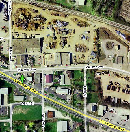
The front of this postcard says it all – Red Top Diner and Shell Station, Highways 24 & 30 East — City Limits, Fort Wayne, Ind.
Three train tracks can be seen behind, and the diner looks to be a converted railcar. The automobile is a mid-’30s coupe. Can’t imagine this part of the Lincoln Highway being quite so rural now. Could that be Maumee Avenue right behind the station, and E Washington Blvd in the foreground? The setting looks right and a couple business as seen in this Google aerial view at bottom center and right seem to fit the layout
Anyone know more about Red Top? The picture was taken some 70 years ago, so it’s critical to ask those who might remember before all traces and memories of such places disappear forever.
As I prepare to hand to my publisher the images for my next book, Lincoln Highway Companion, I’m left with hundreds that just don’t fit. They’re fine photos, but I have a page count that I can’t exceed and it’s already filled. So here’s the first of the runner-ups.
I’ve photographed this neon sign for at least 15 years. It’s in West Virgina very close to the Pennsylvania border. The sign and entrance face the parking lot – in the rear of the nightclub! The Lincoln Highway opened here in 1928 – I’ve always wondered if it originally came down this side and was later moved to the front side of the building to make the road straighter.
In this other angle I posted on Flickr, you can see that under the Carriage Club neon is lettering for what must be an earlier name, the Half Moon Club. Any West Virginians know more about the club or the road here?
“You ever wake up sometimes maybe around 3 o’clock in the morning, you look up at the ceiling, the blackness – you feel that terrible urge to see it all, to get on the road. To smell the pine trees, watch all the rivers, see all the skies, climb all the hills….”
Jean Shepherd was a humorist known to millions through books, radio, and live shows, but is best known to modern audiences for co-writing and narrating (as grown-up Ralphie) the 1983 film A Christmas Story. He also had a very popular TV show: Jean Shepherd’s America, produced by WGBH (PBS) Boston, aired 13 shows in 1971 and 13 in 1985. (They’re available on DVD, or learn more here.) This clip, from the last show of the 1971 season, is the final segment and end credits. Jean and his crew are snowbound in Wyoming at Holding’s Little America motel and truck stop, along the Lincoln Highway and I-80. During the 4-minute video, he talks, in his measured prose, about life on the road, and the American urge to keep moving.
Click the map above for a full-size view of the Lincoln Highway.
Like this blog? You'll LOVE my books!Lincoln Highway Companion features detailed maps and places to eat and stay. Click the book to buy it on Amazon.
Click the Greetings book below to purchase the ultimate guide to the history and route of the Lincoln Highway!
Another fun book! The Ship Hotel: A Grand View along the Lincoln Highway recalls the greatest roadside attraction along the coast-to-coast road.
And for those who LOVE diners, click the book below to purchase our completely updated guide to the history, geography, and food of Pennsylvania's Diners!

 Ely’s
Ely’s