January 25, 2008
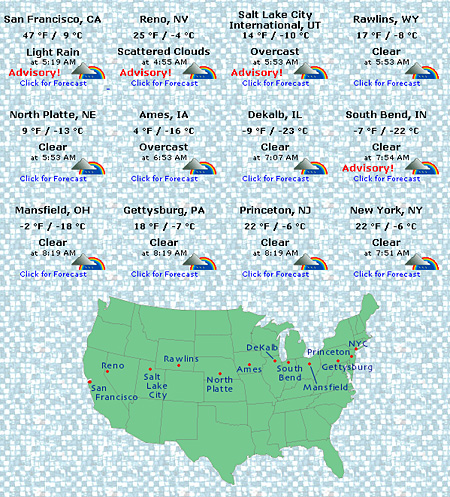
My web site has long had a Lincoln Highway weather map featuring conditions from 12 cities across the country. This morning, as I walked through 7° temperatures in PIttsburgh, I wondered about the rest of the country. As you can see, only San Franciscso can boast of warm temperatures (47°). The rest of the country is 25° or less, with 3 of the 12 cities below zero!
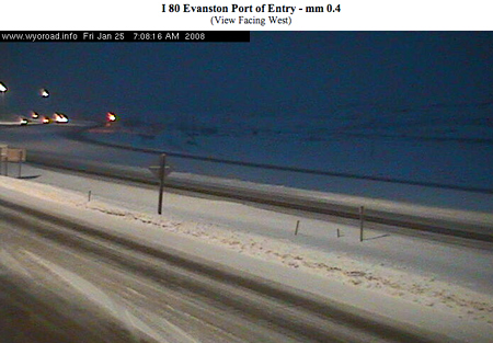
Wyoming DOT has a nice collection of web cams from I-80, which is often parallel to US 30/LH. The roads this morning look pretty clear in the east, but a few, like Evanston at 7 am (seen below), still look slippery:
Tags: cold, Evanston, Lincoln Highway, US map, weather, Wyoming
Posted in highways, Road trip, travel | Leave a Comment »
January 24, 2008
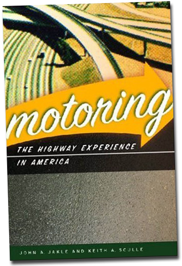
Our friends John A. Jakle and Keith A. Sculle have a new book due out any day, Motoring: The Highway Experience in America. It focuses on recreational travel between 1900 and 1960 by examining various aspects of the built environment and how they’ve shape our view of the “open road.” The 288-page, 75-photo publication from University of Georgia Press follows in the steps of 5 similar collaborations from the authors.
Those other books from Jakle and Sculle have likewise covered topics such as motels, fast food, and gas stations but individually. This book looks at those topics plus roadside tourist attractions, freeways and toll roads, truck stops, bus travel, and convenience stores. Sculle told me, “There are 12 chapters in all, several on the highway system’s formation but also chapters on trucking, auto dealerships & garages….” They’ve been working on this book for 3 years, though of course that’s on top of decades of related research.
Another friend and road scholar, Arthur Krim (author of Route 66: Iconography of the American Highway), describes it as “a bit of business history, a pinch of psychology, a dose of technology, and a full account of the architectural forms that created the current freeway suburbia.”
As for the Lincoln Highway, Sculle says it’s in there:
Nothing new factually but it’s placed into the context of the developing highway system when it was built. Then, in concluding remarks, it is referenced regarding the way some people like to relive the past by driving on the old, surviving parts of the Lincoln Highway.
It’s a book about the Road as Americans consume it. It has links to many things written before but less on the people who started and ran the businesses than how Americans thought of their experience, hence, the subtitle: The Highway Experience in America. The chapter on the Tourist’s Roadside helps put things in perspective.
Motoring retails for $34.95 or get it from Amazon for $23.07 by clicking here .
.
Tags: automobile history, book, highway history, Jakle, Motoring, Sculle
Posted in highways, history, Road trip, roadside, transportation, travel | Leave a Comment »
January 23, 2008
During the California Chapter LHA meeting on January 12 at the new Nut Tree complex on I-80 in Vacaville, Fentons Creamery restaurant was presented with a Historic Lincoln Highway sign by chapter president Norm Root. It will be displayed along with artifacts and photos from one of the best-known attractions in California, The Nut Tree.

Above: Jim Braden, general manager of Fentons Creamery, receives a complimentary Historic LH sign from LHA CA chapter president Norm Root. Photo by Gary Kinst
Fentons traces back to 1894, and has been serving the San Francisco Bay Area at 4226 Piedmont Avenue since 1961. This second location opened here in 2007; it resembles a 1940s ice cream parlor with marble counters and tables, retro booths, and Art Deco lighting.
The Nut Tree was founded in 1921 as a fruit stand under the shade of a walnut tree and grew into a complex of restaurants, gift shops, entertainments, a railroad, and even an airplane runway.

Since The Nut Tree closed in 1996, locals have missed it, so redevelopment plans include nods to the attraction. At the free Nut Tree Family Park, the original Nut Tree train winds through the landscape and past the Harvest Express roller coaster, the I-80 Traffic Jammers bumper cars, California Carousel, and other custom kid rides. Click on the map below to download a large PDF version.

The childhood home of The Nut Tree founder, Harbison House, built 1906-07, has been moved 1,000 feet south to the 3.7 acre family park behind the retail complex. It is being preserved by the Vacaville Museum and will include memorabilia showing the history of the Nut Tree and California. The development also includes lodging, resdiences, offices, and even the Nut Tree Bocce Grove, a two-acre park patterned after the grand public gardens of Europe containing 8 international regulation bocce courts. Visit the Vacaville CVB for more about the Nut Tree development.
Another LHA sign dedication is planned for sometime in the next month at the Summit Garage in Altamont.
Tags: California, Fentons Creamery, highway, Nut Tree, park, restaurant, shopping, travel, Vacaville
Posted in food, highways, history, Road trip, roadside, transportation, travel | Leave a Comment »
January 22, 2008
The 2008 Lincoln Highway Association conference in Evanston, Wyoming, June 17-21, 2008, will feature a new attraction: the Lincoln Highway Art & Photo Show.
Coordinator Kell Brigan, who is also Secretary/Treasurer of LHA’s California Chapter, says “This exhibition is a chance for artists to share their work with conference-goers who also understand the highway’s appeal, and to meet other Lincoln Highway artists and photographers as well.” Below is a plein air watercolor by Brigan herself showing the Lincoln Highway at Adams & Porter roads in Dixon, California, and the town’s water tower.
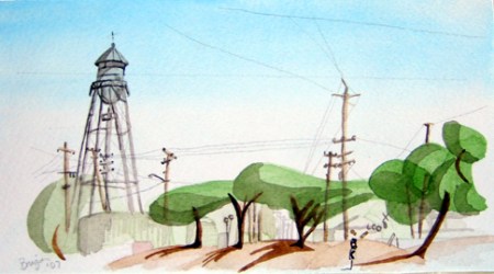
Brigan recalls,
While I was working on the painting (about 10:00 AM on a Sunday in the parking lot of a shop that specializes in maintaining & repairing livestock trucks), a fellow came out of a nearby house (next to a great old building from the ’20s), and said, “OK, I give up. Why, of all things, are you painting the Dixon water tower?!” I explained about painting spots along the highway in California. Turns out his mom, who came by later with the family dog, had helped run one of the “Lincoln Highway Garages” on the same spot in the ’30s.
Visit http://www.lincolnhighwayassoc.org/conference/2008/art_show.shtml for more information and an application, which is due by April 10, 2008. Note that this inaugural show is only an exhibition: no judging or prizes.
Tags: art show, California, Dixon, painting, photo show, Road trip, travel
Posted in highways, history, Road trip, transportation, travel | Leave a Comment »
January 21, 2008
Here’s a nice chrome card of “Alpine Alpa Restaurant – Cheese Chalet” on US 30 between Massillon and Wooster. It was built by Elmer and Ethel Detweiler in 1961 and opened the next year. Note that the sign differs from the above name, calling it Alpine Alpa Cheese and Coffee Shop. A matching card shows the couple inside.

The additions to the bottom of the sign are funny now – one of them must have said, “We need to point out that we’re a Gourmet Shop.” The other replied, “And tell people we’re air conditioned too.”
A later card shows the building greatly expanded with a landscaped fountain. They announced that all 15 cheese varieties came from their own factories, with Hans and Alice Grossniklaus the cheese specialists. It had become “Ohio’s Show Place of Cheesemaking.”
The business is apparently long gone, but the nearby Alpine Homestead restaurant and Swiss market on US 62 between Wilmot and Winesburg was the inspiration for this one. According to its web site, that restaurant was built in 1935 by the Grossniklaus couple as the Alpine Alpa, 25 years before the above one. (New owners renamed it in 2002.) It’s best known for having the World’s Largest Cuckoo Clock – 23 feet tall. UPDATE: The name was just modified again to Grandma’s Alpine Homestead & Swiss Village: short history here and check the owner’s bios.
Tags: cheese, cuckoo clock, Massillon, Ohio, restaurant, Road trip, shop, Wooster
Posted in food, highways, history, Road trip, roadside, signs, travel | 5 Comments »
January 20, 2008
The crash of United Flight 93 on September 11 changed Somerset County, Pennsylvania, in many ways. The curious instantly began streaming to the site just off the Lincoln Highway/US 30, and entrepreneurs began servicing the visitors. The western of the two access roads from Route 30 crosses an original alignment of the Lincoln. A temporary memorial continues to draw visitors, but the National Park Service has a larger memorial planned.

An article in the Daily American reports that local coal trucks are often involved in accidents, and when the Flight 93 National Memorial opens after 2011, US 30 is expected to carry as many as 400,000 more travelers a year. The Flight 93 National Memorial Corridor Study identified a preferred route to guide visitors to the memorial, which ultimately has to travel Route 30. At two public meetings, locals said the road should be wider, better maintained, and have fewer coal trucks. A traffic engineer said the accidents appear to be “relatively isolated incidents.”
The corridor study concludes that the significant horizontal and vertical curvature of the roadway and the corresponding restrictions on sight distance and the heavy volume of truck traffic make traffic safety a paramount concern. This is especially true for a two-thirds-mile stretch east of the intersection with Old Lincoln Highway, the study reported.
The study counts some 400 vehicles traveling to the site daily, and 900 on weekends. Once the new memorial opens, 400,000 are expected annually before tapering to 230,000.
The entrance will be from a third, more easterly location, where Old Lincoln Highway meets Route 30. The intersection would be reconfigured, probably affecting the remaining buildings from the former Emerald Park tourist camp and tavern. For now, PennDOT is planning improvements east of Stoystown including replacing three bridges, and adding turning lanes at the intersection with Route 403.
Locals responded to the flow of cars by creating yard sales, commemorative objects, and businesses to serve visitors. The photo above shows the Long Vu Motel just west of Reels Corners with a new name and sign promoting it’s connection to 9-11. Adele’s Diner across the road was in the news recently for similarly renaming to the Heritage Highway Restaurant, a nod to the range of history along the Lincoln Highway.
Tags: Flight 93, highway, memorial, motel, Pennsylvania, Somerset County, traffic
Posted in highways, history, transportation, travel | Leave a Comment »
January 19, 2008
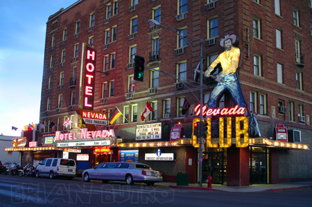 Ely’s Hotel Nevada offers 63 rooms, a casino, and a 24-hour restaurant. When the 6-story hotel opened in 1929, it was the tallest building in the state. Rooms today start at just $35.
Tags: casino, highway, hotel, neon, Nevada
Posted in food, highways, history, lodging, Road trip, roadside, signs | 2 Comments »
January 18, 2008
Snow was predicted today but it was clear and bright at I drove the Lincoln Highway to the Jean Bonnet Tavern a few miles west of Bedford, Pa. The 1762 inn is at a fork of two old military paths: Forbes Road (LH/US 30) and Glades Road (PA 31). A 1928 concrete post at the intersection points out how to stay on the Lincoln.
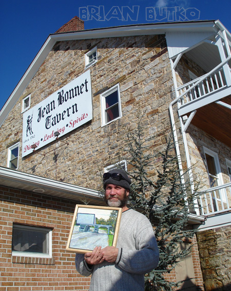
I met Kyle Weaver, editor of my forthcoming Lincoln Highway Companion book. Also spent time with Kevin Kutz, the Lincoln Highway’s leading artist and author of a beautiful book of LH imagery. His artwork of the LH and other roadside attractions can be found in many regional shops. Here he holds his latest, a painting of Haar’s Drive-In Theater in Dillsburg, Pa.
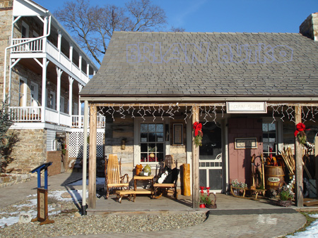
Lunch at the inn was in the bottom-floor dining room. A huge, open fireplace kept the dimly lit room toasty. Afterward we visited the gift shop in a great-looking reconstructed log cabin just a few feet away. They stock lots of locally made products. and many regional books from Stackpole, including my The Lincoln Highway: Pennsylvania Traveler’s Guide. I picked up a jug of local syrup.

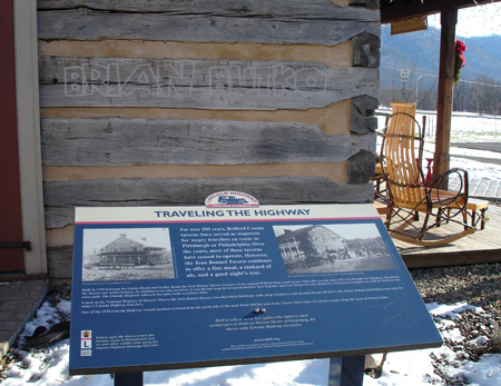
Between the two buildings is a LH interpretive panel courtesy of the LH Heritage Corridor. Next time you’re driving the Lincoln Highway in Pennsylvania, plan to stop by Jean Bonnet for lunch, browsing, and LH history.
Tags: artist, Bedford, drive-in, inn, Jean Bonnet, Kevin Kutz, log cabin, tavern
Posted in food, highways, history, lodging, Road trip, roadside, signs, souvenirs, transportation, travel | 4 Comments »
January 17, 2008
Just a block from the official route of the Lincoln Highway in Sacramento, Suzie Burger is a new restaurant in an old gas station (see red circle on map below). The double-canopy station at 29th and P streets was previously an Orbit station, but looks like it was probably built as a Phillips 66 in the 1960s (see the Spring 2005 Society for Commercial Archeology Journal for more on their history).

The above photo from Tom Spaulding, as seen on Flickr, shows the station’s two canopies, somewhat rare. Tom has more than 7,000 images on Flickr, and check out Tom’s blog for tons more great photos and info from that region.)
The station was later converted to Tune-up Masters, then closed and declined into a local eyesore. Locals are thrilled with the rehab, though early reviews on the food are mixed (though in fairness, three months is a normal period of adjustment). The building is not listed in any historical register so the new owners are to be commended for saving, reusing, and reviving architectural details. They have other high-end restaurants in the area. The original Suzie’s drive-in at 24th Street decades ago; Benny Ogata, son of the founders of the original, is an investor and was helping cook opening day.

The Sacramento Bee reports that a basic Suzie Burger is $1.95, cheeseburger $2.95, each one served with dill pickle and carrot sticks. Grilled onions, pickled jalapenos, sauerkraut, pastrami, chili, and a fried egg range from 45 cents to $1.95 each. The menu also includes hot dogs, chili, and cheesesteaks Milkshakes and soft-serve cones also are served. The cafe red-and-white color scheme includes “Suzie” caricatures by Sacramento artist Matt Rallens. The Suzie’s website has nothing yet but the address. The map is from the LHA Driving Maps CD, available through the LH Trading Post.
Tags: burgers, California, food, gas station, highway, restaurant, Road trip, Sacramento, travel
Posted in food, highways, history, Road trip, roadside, travel | 3 Comments »
January 16, 2008
Clarence Iowa has found that the Lincoln Highway is a route to getting things done. The Clarence Lincoln Highway Committee was founded in 1997 by local businesses and citizens to organize a fun summer fund-raiser for community projects. Their efforts have expanded to many other projects, and this year, the group took over the town’s Christmas festival.
Bad weather delayed the fun one day to December 2, but it was well attended. Businesses contributed generously, such as Kelly Tree Farm, which gave evergreens to line the streets, and individuals baked lots of desserts for a Cookie Walk, with all proceeds benefiting the 2009 Clarence Sesquicentennial Community Projects. The Tipton Conservative covered the event in advance.

A portion of the Festival of Trees display from Christmas in Clarence.
The summer event, the Clarence Lincoln Highway Festival, is still their major effort, which we’ll report on separately. Jen VanOort, editor/designer of the Clarence Community Newsletter and webmaster for www.lincolnhighwayfestival.com, says, “The festival went along at a quiet but profitable pace for many years until two years ago when new leadership was established and the festival really blossomed into an exciting, fun, well-attended event for the entire area, and was even mentioned in the Chicago Tribune.”
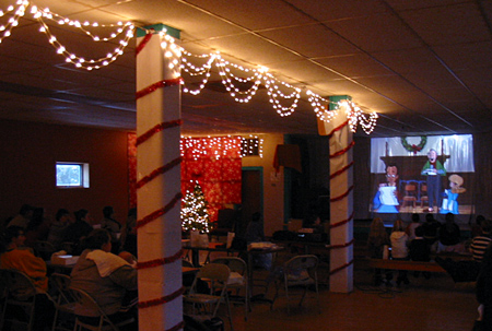
Clarence children enjoying a movie before Santa arrives.
Other plans for the future include a farmers’ market, downtown streetscaping, façade improvements, and concerts and ice cream socials in the downtown park. Jen says, “Keep your eye on Clarence! We have big plans! The funny thing is, our leader, Jamie Wilhau is not native to Clarence or even Iowa, but she feels so passionately about this town, its history, and its potential that she is infectious! Together, we dream up a lot of ideas!”
Jen adds that Clarence is special to highway fans too. “We have the distinction of being one of the only communities left in Iowa with the Lincoln Highway as our main street! No bypass yet … although they are threatening that in the future”
Tags: banners, celebration, Christmas, Clarence, highway, Iowa, trees
Posted in highways, history, Road trip, signs, transportation | Leave a Comment »