A new travel column at San Fransico’s examiner.com features the Lincoln Highway‘s Western Terminus marker and maps out a trip across California and Nevada.

A new travel column at San Fransico’s examiner.com features the Lincoln Highway‘s Western Terminus marker and maps out a trip across California and Nevada.
From the Tracy Press, a story that more Historic Lincoln Highway signs are being placed in Tracy, California.

On Wednesday morning, city employee affixed a Lincoln Highway sign to a metal post on westbound Byron Road just west of Corral Hollow Road, joining three signs were on 11th Street. A second new sign was placed just east of Civic Center Drive on eastbound 11th Street. LHA member Mike Kaelin said signs will soon be placed on the Old Altamont Road between Tracy and Livermore.
LHA president Bob Dieterich adds, “The credit for this belongs to Mike. He has gotten signs installed on Mountain House, Summit Garage at Altamont Pass, and Banta Inn. He has been working with local politicians and is close to agreement for signing the entire Altamont Pass Road.”
The Auburn Journal reports that Norm Sayler, who served as president and manager of Donner Ski Ranch for 46 years, was honored on July 5 for his contributions to the community. He received the 2009 Community Person of the Year Award at the annual Donner Summit Area Association Picnic from Placer County Supervisor Jennifer Montgomery. Photo is from the story.

A resident of Donner Summit since 1954, Sayler was instrumental in making Donner the first ski resort in America to open its slopes to snow boarders in the 1980s. He turned over operation of the ski area a few years ago but continues with the Donner Summit Historical Society, which he founded. Of note to Lincoln Highway enthusiasts:
In the 1990s when Nevada County slated Rainbow Bridge for demolition, Sayler found $500,000 in state seed money to rehabilitate historic state bridges. This effort also ensured that one of the most historic roads in California, Donner Pass Road (formerly known as Highway 40, the Lincoln Highway, the Victory Highway, and the Dutch Flat-Donner Lake Wagon Road), would be preserved and open for all to use
California LHA newsletter editor Gary Kinst writes with an intriguing story and photo. “Wondering how many Lincoln Highway collectors have come across one of these signs? I would guess that there weren’t more than 13 at anyone time. I discovered this sign at a Gas Bash (petroleum collectors swap meet) in Escalon, California. After returning home I searched the internet for Lincoln Highway State Consul signs and came upon the exact same sign that had been sold at auction in Las Vegas last month.”

The original Lincoln Highway Association used a system of consuls to monitor the road for improvements, problems, etc., at state, county, and local levels. Tell us if you know more about these signs and if you’ve ever seen one.
With Wintry weather hitting much of the country, here’s a newsreel from more than a half-century ago reminding us of the dangers atop infamous Donner Pass. The Lincoln Highway crossed the Sierra Nevadas here starting in 1913. The 222 passengers aboard the “City of San Francisco” were stranded for days in up to 20 feet of snow. This newsreel, with dramatic music and narration, details their rescue. The pass is of course named for a party of overland emigrants who were trapped by early snows.

Two long-lost Lincoln Highway markers were unearthed recently in California. They are two of the concrete posts planted along the road in 1928 as a final memorial to Lincoln and the road named for him. LHA president Bob Dieterich explains:
I got an email from Lee Hollifield saying he had two “Lincoln Highway posts.” He didn’t want them resold, but wanted them put on display and his father-in-law, Ray Helm, given credit as the donor. Everybody agreed that the California Chapter of the LHA should take possession. Norm Root and Lloyd Johnson and I drove up to Camino (on the Pioneer Branch of the LH near US 50) to see them. Beside his driveway were the two posts, barely recognizable because of all the red volcanic soil that had leached into the concrete.
Ray had half-interest in a salvage yard and when he and his partner dissolved the business about 20 years ago, they each took what they wanted. There were four posts; we think two of them ended up at the entrance to the El Dorado County museum at the county fairgrounds in Placerville. Ray took the other two home and laid them beside his driveway. Over the years they literally sunk into the ground. Lee dug them out of the ground and they decided to donate them somewhere. They are now at Norm Root’s house waiting restoration. Both are cracked, but Norm can perform miracles on concrete.
At our last California chapter meeting, we voted that one of them should end up in the Folsom History Museum. Folsom is also on the Pioneer branch and the museum is a logical place to display them while being protected from vandalism.

The top photo shows Norm Root and Lloyd Johnson standing by the markers as we found them. The second photo shows the markers being loaded into the back of Norm Root’s Suburban.

The third photo shows the posts being pressure washed in Norm’s driveway.
You can also read about it from the donor’s perspective HERE, and here is one some of his images:


Dennis Crowley continues his story as journeys across California:
California traffic presented some concerns, like that is hard to believe. I had to always be on the alert that someone wasn’t pulling on to the shoulder. Thankfully I had the foresight to install mirrors on the rig which I constantly monitored as well as installing a caution flag. The only time I had any real concern was along the stretch through James Canyon. For anyone not familiar with this stretch it is a slithery, windy, narrow, death trap with narrow and in some places no shoulders. Common sense told me to grab a fanny pack and leave the trailer behind which is precisely what I did. By the time I reached the eastern end of the “gauntlet” the traffic was bumper to bumper and I was doing what I now affectionately call “The Manly Shuffle” meaning that I was walking sideways. Thanks to Paul Gilger’s knowledge of the area I avoided jail time by crossing over the interstate on the railroad tracks west of Cordelia when faced with the onramp to the freeway.
Last but not least there are always concerns with injuries. Given the ground I cover (anywhere from 10-20 miles a day) they do happen and at times in the most inconvenient places. I was pushing so hard to get across the Mojave Desert on old Route 66 a few years ago that by the time I reached Victorville I sprained both ankles. I spent a month off my feet which was still not even enough for full recovery. I had events to attend in Southern California so I picked back up and limped my way to the Santa Monica Pier. In case you are feeling sorry for me hold on to that feeling because it gets worse. Outside San Bernardino a bee stung me in the corner of my eye. He died “an untimely death” but it didn’t make me feeler any better or look any better. The left side of my face swelled up and I looked like the Elephant Man. Looking back maybe I should have made that little stroll down Rodeo Drive. Thankfully I escaped any injuries on my first leg of the Lincoln Highway as well as any “encounters.”
As you can expect everyone I encountered was curious about what I was doing. They were also kind and encouraging and displayed their support of me with everything from a “God bless you” to cold water bottles. All in all I don’t think I could have asked for a better time.
Now I turn my thoughts to May 2009. I will take what I have learned on this leg and prepare over the next seven months to make the trek from West Sacramento to the Reno over the infamous Donner Pass. I pray it will be as much of a success as this journey was.
A complete description of this first leg will be appearing on Dennis’ journal page of his website over the next few weeks at www.walkingamessage.com/.


Top: Lincoln Highway sign in Dixon, California. Above: Pony Express Station at Rockville Rd in Cordelia, and two views of the Bicycle/Pedestrian Pathway in Davis.
A mentioned in my post of 9/3/08, Dennis Crowley is walking across America on the Lincoln Highway, breaking the trip into manageable segments. He’s completed leg one from San Francisco to Sacramento and sent a round-up for our enjoyment. Now back in Arizona, he writes that “It seems like only yesterday that I first conceived of the idea to walk across America on the Lincoln Highway. Tired muscles, a collection of photos, and a pile of credit card receipts are telling me that the first leg of my walk on the Lincoln Highway is over.” Here’s part one of his note, with more to follow later this week:

After completing a walk across America on Route 66 in 2005 doing another walk was the furthest thing from my mind. Getting back to living a “normal” life was the only thing on my mind and that is precisely what I did, but it would only be short lived. In the spring of 2006 I received a phone call asking me to meet someone who was walking across America. When this man, also named Dennis, arrived at my home he was pulling a wheel barrow with his gear in it. It was quite a novelty to be sure, but it got me thinking. What he had was crude, but he had a good idea and I knew I could improve on it. As I watched him leave in the middle of the night the wheels on his “rig” were not the only ones turning.
Over the course of the next two years I worked with a graphic designer developing a logo, pestered custom bicycle builders for ideas on how to build a lightweight trailer, befriended some folks with the Lincoln Highway Association, planned, strategized, and tossed and turned at night. Before I knew it I was at Lincoln Park in San Francisco strapping myself into the harness of my trailer.
No crowds gathered and no bands played. It was just a quiet beginning, but an encouraging one. Kent Laak and Carlos Toste with the Mountain Hardwear Company showed up to wish me well. They presented me with tent compliments of their company and an acknowledgement of their support. And as representatives of the athletic shoe company Montrail they informed me that they would be providing all the shoes I needed. It would prove to be the sign of how things on this first leg would go.
I am not saying that everything went perfectly, but given the type of undertaking this is I certainly can’t complain. I do wish though that I would have been more attentive with my maps. Thankfully I learned that lesson early on. As I told people along the way, “It’s one thing to have to back track when you are driving and quite another when you are walking.” Soon after leaving the Presidio over looking the Golden Gate Bridge I had a bad feeling that I wasn’t where I was supposed to be. I quickly got on my cell phone and called my niece in Oregon to have her check a map. Sure enough, I was ten blocks south of where I was supposed to be. I turned myself around and made my own contribution to global warming with the continual utterance, “I can’t believe I did that!”
There was also one other “learning experience” as I would prefer to call it that I also have to share. Someone at one point recommended that I install brakes on my trailer. I didn’t think that would ever be necessary. Was I ever wrong! I can’t even begin to tell you how difficult it is to walk down the steepest streets in the world pulling a trailer behind you. My friend Paul Gilger nearly fell out of his chair laughing when I told him about it, but I am feeling much better now. (Grin)
Looking back I wish I had a camcorder mounted to myself as I walked. The attention the trailer got was unbelievable and at times even hysterical. Heads turned, people stared, and some people even pulled over just to ask about it. Of all the comments that were made my favorite was from a man in Berkley who said, “Now that’s manpower!” Because the Lincoln Highway coincides with parts of the Pony Express Trail I affectionately deemed my rig, “The “Manly Express.”

The full story of this first leg will appear on his journal over the next few weeks at www.walkingamessage.com, or visit it to learn more about “Walking America The Lincoln Way.”
Above photos are at Dixon and Fairfield, California.
The California chapter of the Lincoln Highway Association reports that Michael Kaelin and Gary Kinst presented a new Historic Lincoln Highway sign to the new owners of the Mountain House, Josie Alvarez and her mother Sara Pina. Sara hopes they can restore the roadhouse to its splendor of 1880-1925, the dates of the original resort being built and its burning. Below, Michael presents the sign to Sara and Josie.

This is the Mountain House in 1910 – click the image to see it larger:

The Mountain House is at the east end of Livermore/Altamont Pass in Alameda County at 16784 W Grantline Road, 4 miles W of Tracy and 6 miles E of Altamont Summit. Its origins stretch back to the gold rush days and are detailed in the July 2008 issue of The Traveler, the chapter’s newsletter. Stop in, have a drink, and say hi to Josie and Sara.
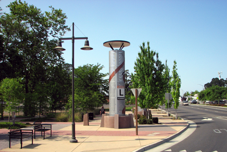
Gary Kinst sent these photos of Auburn Boulevard in Sylvan Corners, California, showing a new Lincoln Highway commemorative sign. When the corner was redeveloped, a US 40 sign was incorporated into the architecture but nothing to reflect the LH, so efforts were taken to rectify that and a new LH sign is prominently displayed.


 Click the map above for a full-size view of the Lincoln Highway.
Like this blog? You'll LOVE my books!Lincoln Highway Companion features detailed maps and places to eat and stay. Click the book to buy it on Amazon.
Click the map above for a full-size view of the Lincoln Highway.
Like this blog? You'll LOVE my books!Lincoln Highway Companion features detailed maps and places to eat and stay. Click the book to buy it on Amazon.
 Click the Greetings book below to purchase the ultimate guide to the history and route of the Lincoln Highway!
 Another fun book! The Ship Hotel: A Grand View along the Lincoln Highway recalls the greatest roadside attraction along the coast-to-coast road.
 And for those who LOVE diners, click the book below to purchase our completely updated guide to the history, geography, and food of Pennsylvania's Diners!


