Posts Tagged ‘roadtrip’

Kearney Covered Wagon Follow-Up

November 10, 2007

A few days after my story ran on the Covered Wagon, an article perhaps inspired by this blog ran on the front page of the Kearney Hub. It even featured my 1950s postcard of the place (though initial editions like the one below erroneously credited the image). Writer Todd Gottula talked to the owner and contractor, who is adding a second floor to convert the building into offices with log siding.

Kearney Hub Front Page

Gottula pinned down some dates: the Covered Wagon was sold to Boyd McClara in 1939, then Nick and Rose Ponticello purchased it in 1963. Nick auctioned many of the souvenirs in 2001 before selling the property to Hayes.

Jamie Hayes, who purchased the property four years ago from Nick Ponticello, says he wants to return it as close as possible to its original look. Since work started around the end of September, motorists keep stopping to talk with contractor Ray White and sons. Hayes says the amount of interest is unbelievable, with most making sure the site is being preserved, not destroyed.

NE_BH_CovWag
A whimsical postcard view from a Covered Wagon attraction, courtesy Bernie Heisey.

Gottula reported in a sidebar story that the site inspired local musician Mike Nicolen to write a song about the Covered Wagon after meeting the Ponticellos in 1999. His thoughts, also on his website, mirror that of many old-time LH fans: “I think instead of building a $50 million archway across the interstate to commemorate westward expansion, they should have sent someone with a tape recorder and camera out to see Nick and Rose.” Nicolen’s site explains further, “Nick and Rose held on to the place and kept it open into their 80’s when health problems finally forced them into a nursing home…. Nick told me once that the Archway people wanted to buy him out and move his beloved Covered Wagon out to the Interstate. He said ‘Why don’t you pick up your Arch and move it out here? I’ve been here a lot longer than you’ve been out there!'”

Nicolen’s song likewise tells how I-80 and the Archway draws traffic from the 2-lane. Click Here to listen to Covered Wagon courtesy of the Kearney Hub or go to Mike’s site and scroll down to the last song, He tells the story from Nick’s point of view. with lines like:

Parked along the highway of our dreams
Facing westward, time moves onward here in the land of opportunity

Now they travel down I-80 doing 85 or more
They gas up at the interchange they’ll never see my store

Millionaire's Marker Mystery west of Chicago

November 9, 2007

A New York Times story I found from December 1913 reported that 88-year-old John Stewart of Elburn, Illinois, was giving away huge sums of money, including $50,000 to improve the Lincoln Highway. He asked that markers be set at each end of the road section that his donation improved. Were those markers ever placed?
Stewart NYT

Elburn is a small town some 40 miles west of Chicago, and just west of Geneva, nestled between the original Lincoln Highway (still called that but better known as Keslinger Road) and IL 38. A 1921 shortcut connected Keslinger Road to IL 38 via Elburn’s Main Street, and a few years later, Keslinger was bypassed entirely. Though rural, suburbia continues to fan out from Chicago; check out this planning map to see how quickly the landscape is changing.

Stewart was in Europe at the time, but the article was datelined Chicago, so it began as a local story. No wonder—he also gave $100,000 to granddaughter Esther Richards as a wedding present, and to all his grandchildren, he bequeathed his estate valued at $750,000. My favorite inflation calculator says that alone is the equivalent of $15.1 million today!

Stewart 3

I checked with some town planners and officials, but no one has heard of the markers. What they didn’t say was that the local elementary schoool is named for John Stewart! Or that the town has preserved his mansion!

Stewart 6

The Great Lakes Leadership Campus on IL 47 occupies the Stewart estate. Director Annette Sheehan (who graciously OK’d use of the photos here) says, “To my knowledge, there are no markers bearing his name on Route 38 through Elburn. I don’t know if there ever were—I’ve never heard about any such markers.” The GLLC website says the 15-bedroom Victorian mansion was built in 1897 for John, Martha, and their 5 children. Its lavish appointments like hand-cut lead glass windows, tiled fireplaces, inlaid wood flooring, wooden ceilings, and in all a hundred types of wood led to the home being featured on a 1908 postage stamp. John Stewart served three terms in the state legislature, and interestingly, funded the paving of Elburn’s Main Street.
Stewart 4

I asked Kathleen Dow at the LHA archives at the Special Collections Library, University of Michigan, if Stewart shows up in their holdings. She found nothing in LHA minutes, correspondence (particularly checking the pledges), or brochures of major expenditures and donors. Could it be that, since the LHA never reached its goal of $10 million, pledges didn’t have to be paid? Kathleen replied, “From what I’ve seen in the LHA correspondence, some pledges were contingent on the pledge goal being reached before any checks were cut (many of the donors, or would-be donors, were businessmen, of course). So, yes, I think a number of pledges were never kept. I think there were also some quibbles about businesses, both small and large, pledging 1% of a year’s profit (I believe that’s what was initially solicited).”

So was the $50,000 ever donated? If so, were markers erected in Elburn or elsewhere? Or did the LHA not get the funds because they never reached their $10 million goal?

Indiana Curriculum to Spotlight Lincoln Highway

November 8, 2007

A Lincoln Highway curriculum unit is being prepared by the LHA Indiana chapter. “Indiana’s Historic Lincoln Highway” will offer a complete 2-week course for grades 3 and 4, formatted to Indiana State Standards. Project Leader Joyce Chambers says a team has been working for a year and a half gathering information and creating hands-on activities for topics such as maps, math, art, music, language, and science. Field research is wrapping up for this year as colder weather approaches.

IN_UM concrete
Above: Pouring the last concrete between Osceola and Mishawaka, Indiana. (Univ of Michigan, Special Collections Library, lhc2276)

The kit will likely contain a Teacher’s Guide, Student Booklet, DVD history of the road, possibly some model race cars (a nod to Carl Fisher’s connection to the Indy Speedway), a LH BINGO Game, and images of the road in Indiana, all in a sturdy tote bag. Sections may include Overview, Construction, Bridges, Tollhouses & Mile Markers, Travelers, Accommodations, Workers along the Road, Fun Sheets, Timeline, Lincoln Highway Sites, Glossary, Bibliography, Evaluation, and information on the LHA. The South Bend Community School Corporation’s Print Shop will donate the printing.

IN_UM_Ideal Sec 
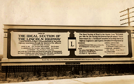
Above: A billboard on the Lincoln Highway’s famous Ideal Section in western indiana, 1927. (Univ of Michigan, Special Collections Library, lhc2793)

Three or four schools will test a pilot version for the 2008-’09 school year, then it will be evaluated and revised for release in 2009-’10 to public libraries and schools along the LH. Further suggestions will be incorporated into a final version available to all Indiana schools, including homeschoolers and private/parochial. It will be available through “check out” at the Center for History Education Department, where other such kits are stored for teachers. A similar highway-themed curriculum is Traveling the National Road Classroom Activity Program.

A kit and PowerPoint show will be presented at the LHA’s 2008 conference, and a presentation at the ’09 event will include feedback from the test year. It sounds like a solid plan, and a model program for other LH states.

IN_UM_curve
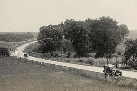
Above: The LHA Packard touring through Indiana, 1925. (Univ of Michigan, Special Collections Library, lhc2313)

For more information, or to make suggestions about content, contact Joyce Chambers at joycechambers47@aol.com (574) 272-5374.

Click the Lincoln Highway Map

November 7, 2007

For those not familiar with the route of the Lincoln Highway, I now have a map available based on the one in my Greetings book. Click the thumbnail below or the really tiny one to the right and you’ll get a US map up to 19 inches wide, just like this one:

Butko Greetings LH map - Med

The first generation represents the “Proclamation Route” of 1913. Towns like Trenton, NJ; Marion, OH; and Ogden, UT were quickly removed (though Ogden would later be put back on).

You’ll also see the Colorado Loop, which the LHA soon regretted but nonetheless approved of for two years. Note also that there were two ways around Lake Tahoe in eastern California. West of Sacramento, the 1928 rerouting is being debated of late as to whether the change was officially endorsed by the LHA board. It’s included because that’s where the LHA’s concrete posts went in 1928.

The first tally of the Lincoln Highway’s length was 3,389 miles (including Camden and Marion but not Ogden), though it would always be in flux due to bypasses and realignments. More than a decade later, the now more-famous US Route 66 would run 2,448 miles from Chicago to Los Angeles (though it likewise would vary in length).

DeKalb IL Road Work Continues into 2008

November 6, 2007

An article in DeKalb’s Northern Star, produced by students at Northern Illinois University, reports that reconstruction of the Lincoln Highway downtown will continue through Summer 2008.

Work in the 100 block, including a bridge replacement and an awkward lane shift, has led to more than a dozen accidents in the past half-year. Joe Spika, construction field engineer and DeKalb County area supervisor for IDOT, said the standard merge there should present no problem: “When people obey it, everything works just fine.” The work, nearly half done, will move to the other side of the bridge by Thanksgiving and will continue through at least mid-Summer.

DeKalb, IL
Above: looking east in the 200 block of East Lincoln Highway, DeKalb.

York PA Chip Factory Story Revealed

November 6, 2007

I just received a letter from Shirley Gillespie complimenting my Lincoln Highway: Pennsylvania Traveler’s Guide book but noting that I missed the story of a potato chip factory along the route operated by her family. My text mentions a Frito-Lay plant west of York, PA, off Gillespie Drive, but little did I know that the road name was a key to the plant’s heritage. The El-Ge Potato Chip Company was founded in 1937 by Leonard Gillespie, named for his initials. A story in the January 1982 Snack Food trade journal reported that the 105,000-sq-ft factory, built in 1965, could produce 4 tons of chips per hour. By then, Shirley’s husband Bob, a nephew of the founder, was president. Here’s a picture from the Snack Food profile showing Bob and Shirley at the El-Ge plant:
ElGe Chips

Shirley says the family sold to Southland Corporation in 1984, which kept the name, then a succession of owners led to Frito-Lay’s purchase. I’m glad Shirley wrote and preserved an important part of her life and Lincoln Highway history.

Hamilton, NV – A Lincoln Highway Ghost Town

November 5, 2007

Ghost towns fascinate most of us, and many books and web sites chart the rise and fall of these once-booming settlements. Rick Pisio (see previous post) captured some amazing views at Hamilton, NV, a mining town on the original Lincoln Highway east of Ely.
NV_Pisio_Hamilton

Silver was discovered here in 1868, and within two years, there were more than 13,000 mining claims. Main Street grew to a mile long and the town itself a mile-and-a-half wide, with two banks, two newspapers, post office, courthouse, school system, water and steam company, churches, fire companies, and a hotel considered the state’s most expensive structure. Hamilton even became the first seat of White Pine County. But the ore layer was thin, and folks left as quickly as they had come. An intentional fire in 1873 (for insurance money) destroyed much of the town.

Even though it’s a 10-mile drive from US 50 over bumpy dirt roads, many make the journey, though their visits, and natural weathering, take a noticable toll. Online images show the brick structures crumbling a bit more every year, and soon, little will remain standing.

Two historic views from Ghost Towns: How They Were Born, How They Lived, and How They Died by Tom Robotham (Running Press, 1993) show the Wells Fargo bank as the town’s most prominent structure:
Ghost Towns book

See more of Rick Pisio’s photos from this and other Western ghost towns at rwphotos.

A detailed history of Hamilton is available at White Pine County Nevada History and Genealogy Research site.

For USGS maps on getting there, check The Lincoln Highway: Nevada by Gregory Franzwa and Jess Petersen. The 1913 LH stretches over maps 39-43.

Fan Posts UT-NV Tour on American Road Forum

November 4, 2007

The American Road Forum is a great place to ask questions and get info from roadside experts, including, of course, for the Lincoln Highway. You can browse as a guest, but sign up so you can add your own questions and answers.

In May, Rick Pisio (whose website of impressive photos can be found in my Helpful Links section) asked about driving the LH west from the Pacific, especially the original alignment around the Great Salt Lake Desert. He got some wonderful insights and detailed replies:
http://americanroadmagazine.com/forum/index.php?showtopic=383

Rick made the trip in late July with his father Matt (who turns 70 this month – Pisio on Am Rd Whhappy birthday!) and 14-year-old son Richard, whom he says really enjoyed it: “I talked enough about the history of the roads we traveled and he listened in on the conversations my dad and I had during the trip enough to understand that what we were doing was not your normal vacation. I think he also realizes that opportunities for 3 generations to travel on a trip like we did do not happen that often.” Must have worked – Rick says they hope to take another trip next year.

Rick’s posts to the American Road Forum picked up his journey three days into the trip, starting at West Valley City, Utah, traveling through Skull Valley to the US Army Dugway Proving Ground:
http://americanroadmagazine.com/forum/index.php?showtopic=522 Here’s a view from the start of the trip looking south on the original LH in Skull Valley:
UT_Pisio_SklVly

Four subsequent entries through Utah and across Nevada can be found on the “Lincoln Highway / U.S. 30 / U.S. 50” board:
http://americanroadmagazine.com/forum/index.php?showforum=24

Here’s a view looking east to the Goodyear Cutoff, a contentious shortcut that’s been off-limits for more than a half-century. The sign’s faded lettering reads “Dead End Road, No Trespassing, Government Property.” The short post on the right has the Lincoln Highway logo and “Lincoln Highway” down its length:
UT_Pisio_Gdyr

Days later, he captured sunset at the International Cafe in Austin, where they had the last dinner of their trip:
NV_Pisio_IntlCafe

Anyone wanting to make the trip themselves will enjoy Rick’s storytelling and evocative images, plus maps of each day’s journey. All his posted photos, plus some not in the American Road reports, can be found at http://www.rwphotos.com/Scenics/scenicmain.htm

We can’t wait for next year’s trip.

Produce Stands Part of Region's Heritage

November 3, 2007

One of the reasons for making the trip to Gettysburg was to see the sights of Fall along the Lincoln Highway, especially produce stands. Central PA is known for its apples, peaches, cherries, and other farm products, though suburbanization is a looming threat to orchards. On the way home, we stopped to buy some pumpkins, tomatoes, apple butter, and Halloween decorations.

West of Chambersburg is Shatzer’s Fruit Market (2197 Lincoln Way West), founded 1933. Outside is one of the LHHC‘s Pump Parade decorated fiberglass pumps:
PA_Orch3

Relatives of the Shatzer family, Bingham’s Orchard and Market (9823 Lincoln Way West) farther west in St. Thomas has a larger building stocked with cider, jams, and such:
PA_Orch1

PA_Orch2