“You ever wake up sometimes maybe around 3 o’clock in the morning, you look up at the ceiling, the blackness – you feel that terrible urge to see it all, to get on the road. To smell the pine trees, watch all the rivers, see all the skies, climb all the hills….”
Jean Shepherd was a humorist known to millions through books, radio, and live shows, but is best known to modern audiences for co-writing and narrating (as grown-up Ralphie) the 1983 film A Christmas Story. He also had a very popular TV show: Jean Shepherd’s America, produced by WGBH (PBS) Boston, aired 13 shows in 1971 and 13 in 1985. (They’re available on DVD, or learn more here.) This clip, from the last show of the 1971 season, is the final segment and end credits. Jean and his crew are snowbound in Wyoming at Holding’s Little America motel and truck stop, along the Lincoln Highway and I-80. During the 4-minute video, he talks, in his measured prose, about life on the road, and the American urge to keep moving.
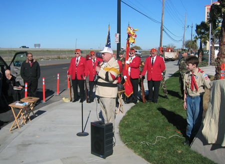
More than 50 officials, friends, and members of the Wiggin Family and Lincoln Highway Association braved chilly temperatures to dedicate a marker that honors both the Lincoln Highway and Wiggin’s Trading Post that opened there in 1924. The ceremony was held Saturday, December 8, 2007, at 15600 S. Harlan Road in Lathrop, California.
Above: At the Lathrop marker dedication, from left to right: Bob Dieterich, James Lin, Gary Kinst, Paul Gilger, Norm Root. Lloyd Johnson, Mike Kaelin, and Carolyn Lignos. The plaques read: (top) Lathrop Sunrise Rotary; (middle) America’s First Coast to Coast Road Established 1913; (bottom) 1924-1967 Site of Original Wiggin’s Trading Post Serving Travelers Along The Lincoln Highway.
Francis Wiggin’s Granddaughters, Janet and Patti, presented photos to master of ceremonies John Serpa (SEE BELOW), a member of LHA and the Lathrop Sunrise Rotary Club. Marine Corps League Detachment #109 from Modesto presented the colors, and Boy Scout Troup #425 from Lathrop led the singing of the National Anthem and the unveiling of the monument.
A Marine Corps League Certificate of Appreciation for Loyalty and Patriotism was presented by John Treantos, Commandant of #109, to Mr. Dalwinder Dhoot for flying the American flag continuously 24 hours a day, 7 days a week for 14 years at Joe’s Travel Plaza. Dhoot and family own the new Best Western Hotel at the site, and graciously allowed the Rotary to erect the marker. Mr. Dhoot then invited all guests to join the grand opening festivities for the 3-floor, 81-room hotel and provided complimentary food and beverages.Speakers included:Kristy Sayles, Mayor of Lathrop.Norm Root, President, California Chapter of the LHA (SEE BELOW).
Thanks also go to:Gabe Young, cement and engraving of stone monument.Brian Green, Signarama of Tracy.Stephen Dresser, President, Lathrop Sunrise Rotary.Dolores Delgado, Chief of Police, City of Lathrop.Charles Edwards, Boy Scout Troup #425 Leader.Richard Wiggins, Grandson of Francis Wiggins.Mary Kennedy, President, Lathrop Chamber of Commerce.And I again thank Gary Kinst for helping with info and images for this report.
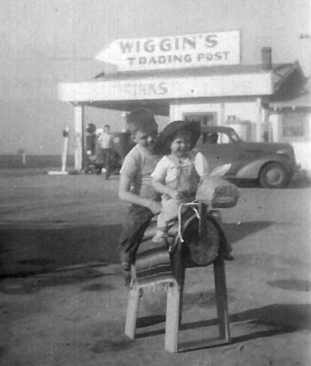
A marker was dedicated Saturday, December 8, along South Harlan Road at Thomsen Street in Lathrop, California, to commemorate the Lincoln Highway and a family business that once occupied the corner. Francis Wiggin opened Wiggin’s Trading Post along the Lincoln Highway south of Stockton in 1924. He carried Gilmore Gasoline, then in 1932, began selling “Indian Head” Gasoline, which he had patented. He also sold Indian souvenirs, learned from his days working with the Buffalo Bill Wild West Show.
Francis Wiggin’s son Francis Porter Wiggin II and his wife Ruth had seven children: Frank, Paul (b. 1934), Richard (b. 1936), Tom (b. 1940), Janet (b. 1946), Don, and Patti (b. 1955). Above, Wiggin’s grandchildren Janet and Tom ride a play horse/burro in 1949. Near the pumps might be one of their brothers.
Son Francis II joined the business around 1936, and Francis Sr. passed away in 1950. The Trading Post closed in 1967, but grandson Richard operates (but has it for sale) Wiggin’s Trading Post in Chilcoot, California at 94139 Highway 70. Another Wiggin’s Trading Post is said to be in Arizona but the location and owner are not known.
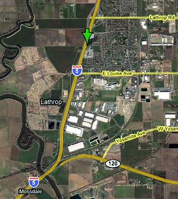
The Lincoln Highway went south from Stockton through Lathrop on what is now Harlan Road on its way to Tracy. I-5 now closely parallels the old road. Information about the ceremony will follow in a separate post. Thanks to Gary Kinst for helping with info and the image.
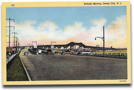
An article in The New York Times examines the current state of the Pulaski Skyway, an overhead road that bypassed part of the Lincoln Highway in northern New Jersey in 1932. The 3-mile-long superhighway, named for Revolutionary War general Casimir Pulaski, was built to handle the traffic resulting from the opening of the Holland Tunnel in 1927. It carries traffic above the region’s heavy industrial and commercial areas. On its first day of operation, 48,611 cars used it; today the average is 85,000 according to the Department of Transportation. The skyway was an engineering marvel when opened in 1938: the American Institute of Steel Construction called it the most beautiful steel bridge, and it still is a grand structure. But its lanes are narrow, and after the tragic collapse of a bridge in Minneapolis that employed the same antiquated design, it’s again being reviewed. All of the 700-such bridges in the US lack a secondary support, “meaning that the failure of just one piece of steel could send them plummeting to the ground.”
NJ Governor Jon S. Corzine says that “instead of spending the $10 million a year now planned to keep the skyway safe and operational, it might be wiser to replace it,” but that would cost $1 billion. The bridge was inspected in spring 2007, but the NJ Department of Transportation, “citing security concerns, refused to release the records of that inspection or discuss whether the findings differed substantially from those of the previous inspection.” Another inspection was ordered after the Minneapolis collapse.
So the most recent data is from a 2004 inspection. On a scale of 0 to 9, with 9 being perfect and 0 requiring a shutdown, the skyway was rated 4 for the physical condition of its structural members and 5 for the physical condition of its piers and other substructure components.
According to the Times, “Those numbers are not dire. But the scores are similar to those assigned to the bridge in Minneapolis. It received a 4 for structure and 6 for substructure during its most recent inspection.” That makes it “structurally deficient” though “not a risk of imminent collapse.”
Although it is 35 years older than the Minneapolis span, it may actually be safer; since less was known about structural support then, more steel was often used than was needed. And because Jersey City banned trucks from the bridge in 1934, it’s taken less of a beating. That’s why officials want to assure drivers not to panic, that there’s plenty of time to plan for repairs or replacement. Let’s hope so.
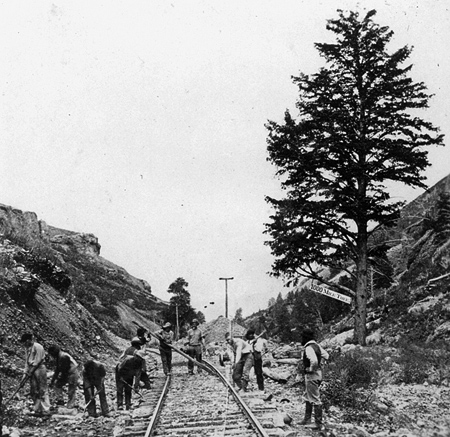
The Lincoln Highway often followed the course of the Transcontinental Railroad out west, mostly in spirit but sometimes atop it. When the railroad was built through Weber Canyon in eastern Utah in 1868-69, workers planted a “1,000 mile tree” to mark the point 1,000 miles west of their starting point of Omaha, Nebraska. I see references occasionally to the tree, and have noticed a couple stereoview cards online. A few photos were taken too, such as this one as the rails are laid in 1869 from the U.S. Geological Survey Photographic Library:
Check out the sign hanging from it!
The Lincoln Highway cut through the canyon some 45 years later, as did I-84 probably 60 years after that. I don’t remember seeing the tree or signs for it, but it is said to still be in Wilhelmina Pass, a mile east of Devils’ Slide. Click on the thumbnail below for a recent view from I-80 (and once there, click the magnifying glass to see the phhoto much larger):
That looks to be the pine tree on the right, next to the white square, which is probably a sign. Surely the tree has been written about by Utah historians or by railroad fans. Can anyone tell us more about it?
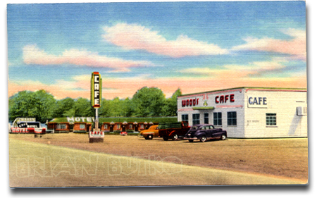
This 1940s postcard advertised Wood’s Motel & Cafe – “ultra modern and steam heat” – on US 30 South in East Evanston, Wyoming. Has any part survived to visit during the 2008 LHA conference this June?
Three large winter storms have combined to cause what is being called by the National Weather Service “easily the strongest systems to impact the West Coast this winter season and quite possibly the last few years.” The affected area stretches from San Francisco, where 1.5 million lost power, to Fernley, Nevada, east of Reno, where a half-foot of snow caused a 30-foot break in a levee wall of the Truckee Canal, releasing water 3 feet deep into town, flooding homes and stranding 3,500. US 50 has been closed at times for avalanches, and those wanting to drive it must use tire chains. Ten feet of snow is expected in the Sierra Nevadas by Sunday.
LHA president Henry Joy takes a break for fun in the high snows of the Sierras.
As the storm moved eastward Saturday, it sent whipping winds and heavy snow into parts of Utah and Colorado, prompting authorities to close major highways — including Interstate 80 east — as the National Weather Service warned that traveling in the area “will put your life at risk.”
“Do not attempt to travel in the Sierra (region) today,” the meteorological agency said in a special weather statement….
One gust near Donner Peak measured 163 miles per hour.
The New York Timesreports that I-80 was closed overnight, then reopened Saturday but tire chains were mandatory on a 60-mile stretch. Governor Arnold Schwarzenegger was even in touch with Homeland Security Secretary Michael Chertoff.
Storms also spread across Wyoming on Thursday, causing, among other damage, the roof and walls to collapse at the Moondance Diner near Green River. The 1930s factory-built diner was moved in 2007 on a trip closely paralleling the Lincoln Highway: from near the Holland Tunnel entrance in lower Manhattan, New York City, to the small town of LeBarge, Wyoming. Read more here.
Here’s a fun video of downtown DeKalb, Illinois, assembled from thousands of still images, which are themselves a bit distorted in day-glo colors. The view races up and down Lincoln Highway at a stop-action 180 mph to the tune of “High Way” by guitar legend Link Wray (sounding like a faster version of his big hit, Rumble). It’s a jumble of imagery, but anyone familiar with DeKalb will recognize many landmarks – even if seen only for a second.
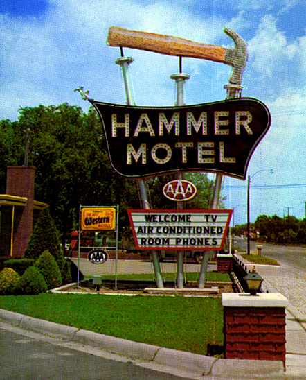
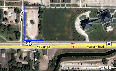
The Hammer Motel on the Lincoln Highway in Kearney, Nebraska, was famous for its sign topped by a giant hammer and three supporting poles made to look like big nails. Named for the Hammer family, it served travelers for decades before being demolished in 1995 for parking.
Piecing together the story from various sources, John and Nina Hammer were married in 1935, then moved from Omaha to Kearney in 1938. John served in WWII and in 1947 they built the motel along Watson Blvd/24th St/US 30 West. A 1952 listing in the city’s Polk’s Directory also lists Fred and Belle Hammer as owners. Signs show it was a Best Western member, and matchbooks advertise that it was part of the Friendship Inn chain.
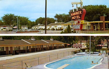
The family sold the motel in 1962 and it closed in 1987. The adjacent University of Nebraska at Kearney then acquired it for student housing known as Hammer Hall or Hammer Apartments or just “The Hammer.” School literature described it as “a unique living opportunity for the approximately 50 upperclass residents of this remodeled hotel facility. Each convenience-style apartment has a private entrance, living room and bathroom. A variety of room sizes, laundry and kitchen facilities, front desk services, and ‘front-door’ parking are some of the significant advantages of the facility.” But in 1995, it was razed to create additional campus parking – see blue box below for what I believe is the site.
A 2003 newsletter article explained that the Hammers were longtime supporters of the university, and that a $27,000 gift from son Fred E. Hammer to the University of Nebraska Foundation would landscape the lot. His donation also provided for “benches, tables and columns reminiscent of the columns that marked the entrance to the old Hammer Motel” to make the parking lot “a place for students to gather.” There was also to be a plaque mounted on one of the columns commemorating the motel as a historic Kearney site. “The parking lot will still be functional,” Hammer said, “but now it will be pretty as well.”
Nothing remains of the motel except the basic shape of the site, some postcards, and the parking area now known as Lot 27.
“Windy City Road Warrior” Dave Clark (author of Exploring Route 66 in Chicagoland and Route 66 in Chicago) posted an interesting story about the 81st anniversary of the federal highway numbering system. Although the highway plan was finalized in November 1926, the public announcement was delayed until January 1, 1927. Clark references a Chicago Tribune article from January 2, “U.S. Marks Ten Main Roads With Route Numbers” that explains the system that has been used ever since for federal highways: east-west route have even numbers, north-south have odd, with lowest numbers in the north and east. The 10 main transcontinental route numbers ended in 0, and the main N-S route numbers ended in 1 or 5. A tentative plan had been submitted to the American Association of State Highway Officials (AASHO) in November 1925, followed by a year of wrangling and revisions. Standardized signage was also adopted.
All this was in response to the growing tangle of named highways and their informal, inconsistent markings. It did not release funds for the highways; the focus was on standardized naming and marking, The only nod to financing upgrades was to “unimproved sections of which will be given priority in improvement,” if and when any were made.
Above: A Gulf map of PA, late 1920s, shows the LH numbered as both US 30 and PA 1. The state numbers were discarded after just a few years. Seen here is from roughly Breezewood to Lancaster.
Though named trails were not banned or eliminated, none of the multi-state ones got a single number, but rather were broken into several numbers. Named highway orgnizations could see that the plan would render their roads obsolete; the LHA grudgingly accepted the plan but asked for consideration of being designated route number 30. It got it for much of the way, originally from Philadelphia to Salt Lake City. Still, as Weingroff writes, LHA president Henry Joy
was so bitter that he wanted to send, but did not, a note to President Coolidge, his Cabinet, and all Members of Congress:
“The Lincoln Highway, a memorial to the martyred Lincoln, now known by the grace of God and the authority of the Government of the United States as Federal Route 1, Federal Route 30, Federal Route 30N, Federal Route 30S, Federal Route 530, Federal Route 40 and Federal Route 50”
The New York Times expressed similar sentiments: “The traveler may shed tears as he drives the Lincoln Highway or dream dreams as he speeds over the Jefferson Highway, but how can he get a ‘kick’ out of 46, 55 or 33 or 21?” Little did they know…!
Click the map above for a full-size view of the Lincoln Highway.
Like this blog? You'll LOVE my books!Lincoln Highway Companion features detailed maps and places to eat and stay. Click the book to buy it on Amazon.
Click the Greetings book below to purchase the ultimate guide to the history and route of the Lincoln Highway!
Another fun book! The Ship Hotel: A Grand View along the Lincoln Highway recalls the greatest roadside attraction along the coast-to-coast road.
And for those who LOVE diners, click the book below to purchase our completely updated guide to the history, geography, and food of Pennsylvania's Diners!